No ---- they are all around my houseLots of positive bolts around tonight.
-
Hello, please take a minute to check out our awesome content, contributed by the wonderful members of our community. We hope you'll add your own thoughts and opinions by making a free account!
You are using an out of date browser. It may not display this or other websites correctly.
You should upgrade or use an alternative browser.
You should upgrade or use an alternative browser.
July Surprise!
- Thread starter Ollie Williams
- Start date
Shaggy
Member
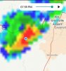
I hear fire trucks now this may have set a house on fire close byNo poop they are all around my houseView attachment 44850
This closeI hear fire trucks now this may have set a house on fire close by

Shaggy
Member
I hear fire trucks now this may have set a house on fire close by
The backside lightning was pretty cool. I have a wide open view to my east and me and little boy were watching from the breezeway. Got this one on video. I love my little boy loves weather.
Shaggy
Member
Man i might be in for a doozy of a night. More rounds inbound and it's raining hard again.
Downeastnc
Member
I'm golden right no way I get blanked.. .right...

The backside lightning was pretty cool. I have a wide open view to my east and me and little boy were watching from the breezeway. Got this one on video. I love my little boy loves weather.
Yeah these things are all firing off as they die. Awesome video btw just showed the gf and got aren't kids awesome. Thanks
Shaggy
Member
Yeah these things are all firing off as they die. Awesome video btw just showed the gf and got aren't kids awesome. Thanks
Well they are
Shaggy
Member
I'm golden right no way I get blanked.. .right...
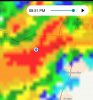
View attachment 44855
Yeah that does a good job showing the explosion of lightning i was seeing. There were some great bolts.
Shaggy
Member
Just a constant flicker of lightning but more cloud to cloud now. Like a strobe light outside......havent seen them this hot in a while.
Shaggy
Member
Its happening!Crushed
Shaggy
Member
Its happening!
Finally. I retract my earlier remarks and now SNOW fo everyone this winter.
You're too niceFinally. I retract my earlier remarks and now SNOW fo everyone this winter.
Shaggy
Member
This reminds me of years past. Late evening storms followed by hours of stratiform late into the evening with long rolling thunder. These use to be a couple times a week occurrences back in the 80s and 90s.
blueheronNC
Member
Lovely 0.07” in my neck of the woods, completely surrounded by 1-2” totals.

1.24 and still going!@SD how much you end up with? I got central Harnett issues nowadays, completely surrounded today, finished with a whopping .02
Oh no man that sucks when those issues start its hard to stop
Shaggy
Member
1.24 and still going!
Oh no man that sucks when those issues start its hard to stop
That's cool that we both ended up with 1 inch totals after the screwjobs we have seen over the last month.
Tomorrow looks even more active. Marginal risk
NBAcentel
Member
Lightning is crazy to my south
NBAcentel
Member
This boundary will probably play a role in tomorrow’s setup 
Brent
Member
First band from Hanna?
I will be going back to Dallas in the morning so probably one of the few I will see lol
I will be going back to Dallas in the morning so probably one of the few I will see lol
accu35
Member
Have fun on your Covid 19 storm chase LOL!!!First band from Hanna?
I will be going back to Dallas in the morning so probably one of the few I will see lolView attachment 44863
blueheronNC
Member
That's cool that we both ended up with 1 inch totals after the screwjobs we have seen over the last month.
The NC screw job stands at one now I guess. Haven’t had a daily total over 0.50” since June 16th. Yep, what summer thunderstorms? We just get leftover anvil stratiform.
Downeastnc
Member
The NC screw job stands at one now I guess. Haven’t had a daily total over 0.50” since June 16th. Yep, what summer thunderstorms? We just get leftover anvil stratiform.
I did get around .25" last night so that ended the no rain streak here but yesterday the hi res models had several rounds of storms over me today and this morning almost nothing today...NWS still has us at 70% though so we shall see.
After all the thunder and lightning between 4pm and midnight all I got was a lousy .10”. I must have some kind of [mention]metwannabe [/mention]dome over me.
Debris clouds and lingering shallow convection ftl. I think we still get good to widespread coverage this evening but it will either be waiting for outflows or a loosly organized band moving in versus our areas bring the initiation pointI did get around .25" last night so that ended the no rain streak here but yesterday the hi res models had several rounds of storms over me today and this morning almost nothing today...NWS still has us at 70% though so we shall see.
3.26" in the rain gauge this morning...much more than I thought...still raining.
Summerfield, NC
Summerfield, NC
smast16
Member
1.44" In the initial round of heavy thunderstorms up until 4pm. Then 3 or so hours of backside stratiform rain, bringing the total to 2.14"
Then another round of steady medium / sometimes heavy rain, and had me up to 2.83" Totals as of 7:50am when i left for work, but it was still raining. I think i'm approaching 3" storm totals myself. Walked the trash out this morning, and the ground was squishy...
I'll take my ban if needed....
Then another round of steady medium / sometimes heavy rain, and had me up to 2.83" Totals as of 7:50am when i left for work, but it was still raining. I think i'm approaching 3" storm totals myself. Walked the trash out this morning, and the ground was squishy...
I'll take my ban if needed....
NBAcentel
Member
Today looks solid south of I-40, cooler temps aloft (even with poor lapse rates) May allow tall storms (50+KFT to get some hail) along with the typical steep 0-3km lapse rate/high Dcape/high instability driven damaging wind threat, there will be a increased amount of flow today so maybe some weak organization, need these clouds to go
Avalanche
Member
I know its summertime storms, but its really amazing how localized theyve been. Still looking for rain while Jordan Lake area is soaked.
Brent
Member
More Hanna "rainbands"
Honestly I’m worried about getting enough instability. It’s been pretty overcast at times this morning and temps are not jumping up at all the way they have for the last week or so.Today looks solid south of I-40, cooler temps aloft (even with poor lapse rates) May allow tall storms (50+KFT to get some hail) along with the typical steep 0-3km lapse rate/high Dcape/high instability driven damaging wind threat, there will be a increased amount of flow today so maybe some weak organization, need these clouds to go
Honestly I’m worried about getting enough instability. It’s been pretty overcast at times this morning and temps are not jumping up at all the way they have for the last week or so.
Meh, it's only 10. Per satellite, we should some clearing before too long. If it were, later on, I'd agree.
You’re probably right. I guess I was a bit disappointed to miss out on the fun yesterday. I do think that just about all of us in the western and central Carolinas should get something beneficial over the next couple days.Meh, it's only 10. Per satellite, we should some clearing before too long. If it were, later on, I'd agree.
Yeah the southern half of the cloud deck is eroding quick. Starting to get some new CU growth back toward the foothills too. Its getting easier to make the case storms fire along 40 along the differential heating boundary then progress south through the afternoon/ eveningMeh, it's only 10. Per satellite, we should some clearing before too long. If it were, later on, I'd agree.
NBAcentel
Member
Just like that skies have mostly cleared