• Hello, please take a minute to check out our awesome content, contributed by the wonderful members of our community. We hope you'll add your own thoughts and opinions by making a free account!

Possible Severe Weather April 22nd-23rd

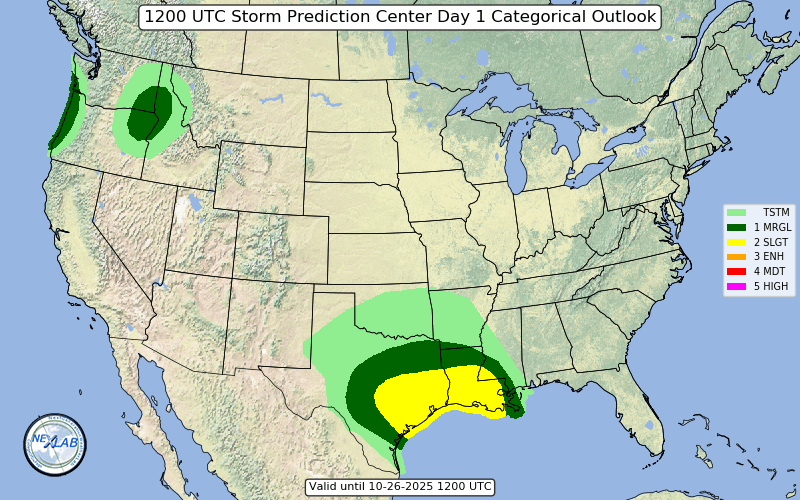
This morning round of rain / embedded storms seems to be progressing fairly quickly. It's already through BHM, with things fairly clear behind it.

Will be interesting to watch temps...I’m @ 53 right now with light to moderate rain. Will be interested to see if anything pops to the west with all the convection to the south. Several tornado warnings on-going right now with the MCS.
 
I don't understand this "oh, we're not in an enhanced/mod area, so it's a bust and we're not getting anything" mentality some have here. Models still are showing a threat for slight areas (north metro). Sure, we may get just a rumble of thunder, but we could also get something much worse.

It's like some of you want a tornado to drop on your house.

Hatched outlook boxes are an essential part of tornadogenesis, along with the colors orange, red, and purple.
 
Dude you are about to get a timeout
Why? If you go from a level 3 hatched to a marginal risk in less than 12 hours, that shows you probably never should have been in the risk to begin with. I’m just stating facts. None of the models showed anything warranting NC being in a level 3 hatched. If you are handing out timeouts for stating evidence then I don’t know what to say...
 
Why? If you go from a level 3 hatched to a marginal risk in less than 12 hours, that shows you probably never should have been in the risk to begin with. I’m just stating facts. None of the models showed anything warranting NC being in a level 3 hatched. If you are handing out timeouts for stating evidence then I don’t know what to say...
Because you are arguing with posters, bashing the spc, and causing a commotion
 
Because you are arguing with posters, bashing the spc, and causing a commotion
No. Quote one post where I have been arguing with someone? Never happened. When did I cause a commotion? Never happened, I’m just posting what the models are showing. Never bashed the SPC, I just stated that NC never should have been in the 10% hatched risk which is a fact. They got moved to a marginal risk within 12 hours which shows it was an obvious mistake. Not a single model showed that was anywhere near warranted.
 
The back edge of the rain shield is approaching the GA/AL state line around I-20. It appears to be moving at a solid clip. If it can clear out of here completely by lunchtime, that may change things. You really do have to nowcast this.
 
swody1_categorical.png


SPC has significantly cut back on the enhanced risk for today. Redevelopment of storms this afternoon is more in question, and the enhanced risk is now basically along and head of the line of storms this morning,
 
When final line moved through here last night it was nothing more than a little thunder, little wind and little rain.
 
I agree with SPC. I didn’t think the MCS line now would be as much of a big deal because models were all over the place but I think its very evident now that’s what is likely to happen. Also looking at if there is any redevelopment of storms, the best shear axis is well moved east of that area so maybe severe but don’t think that big of a deal.
 
Looks like some storms are firing back in Mississippi.. Will be interesting to see what those will do as they progress eastward.
 
I agree with SPC. I didn’t think the MCS line now would be as much of a big deal because models were all over the place but I think its very evident now that’s what is likely to happen. Also looking at if there is any redevelopment of storms, the best shear axis is well moved east of that area so maybe severe but don’t think that big of a deal.

I feel like even the models that weren't showing much rain to stabilize things in NC were still keeping the severe threat well to our south.
 
Back
Top