• Hello, please take a minute to check out our awesome content, contributed by the wonderful members of our community. We hope you'll add your own thoughts and opinions by making a free account!

Miserable March

Basically all of the southeast Alabama through the Carolinas is what it was headed towards .. of course this could all change since it’s 220-240 hours out


Ahh, okay... thanks! I thought you were talking about this upcoming week. Wouldn't be surprised to see it come to fruition though. Considering how active it's been this winter, I can't imagine that changing as we enter spring.
 
Since it’s trending towards a clipper does that the upstate is out of it looks like more hits in the N.C. mountains than anywhere yet
I think if we play our cards right these types of things can bring some convective snow east of the mountains
man, that’s wild. My brain was in the exact same place at the exact same time. Did we just become best weather friends?
 
I think if we play our cards right these types of things can bring some convective snow east of the mountains

man, that’s wild. My brain was in the exact same place at the exact same time. Did we just become best weather friends?

I guess so !! And these soundings remind me of something ?, maybe just maybe ? 5D40ED4A-D37D-46CC-B6B0-F9A713E2D7DE.pngEF202AC0-EFD3-462D-917B-8A082B5D9115.gif
 
That snow was all convective too. It had snowed for almost 5 hours that morning in Charlotte metro with temps in the mid 30s. Here in Wingate the sun actually came out early in the afternoon and warmed up temps to the lower 40s. I remember watching the radar that whole afternoon and it looking like a line of spring severe thunderstorms heading right for us. As soon as the snow started it was very heavy with thunder and the temperature crashed from 41 to 32 in just about 5 minutes. We ended up with 2.5 inches in only about an hour and fifteen minutes of snowfall
 
Looks like Pickens county didn’t get much out of that system I hope this one doesn’t do the same I hope we score more this than what happen in 2013

I don’t recall any accumulations from that one in 2013 to be honest. Mountains broke it up then it regenerated to our east


Sent from my iPhone using Tapatalk
 
18z GFs not a favorable trend for a coastal. The GEFS is more favorable for a clipper (with one costal)

View attachment 36288
The thing is this situation is so delicate that just a few minor tweaks (the ones these models love making within 3 days) that coastal becomes a reality .. obviously long shot rn with little support but that ensemble member shows what happens if the right tweaks are made
 
I don’t recall any accumulations from that one in 2013 to be honest. Mountains broke it up then it regenerated to our east


Sent from my iPhone using Tapatalk
Well I hope this one is different than that one I hope we score on this one this time
 
It’s gonna have to go around the mountains or into the gulf. Clippers occasionally give us snow but there fairly rare


Sent from my iPhone using Tapatalk
 
I find it interesting that the ao/nao managed to stay positive all winter. Also the nao was supposed to be predominantly negative due to low frequency forcing.

Not to mention our tendency to get a +TNH but a +EPO, this May very well cause issues for severe season
 
That’s a solid signal from the GEFS once again just like our last storm for it being 7 days out View attachment 36296View attachment 36297
Going to want the OP to start showing something IN ADDITION to a few more members showing something. As is, there's at least a chance, which is a win given this miserable winter. But to have a realistic shot, we need more agreement and more than one big dawg member.
 
Do you have a accumulations map of that one


Sent from my iPhone using Tapatalk

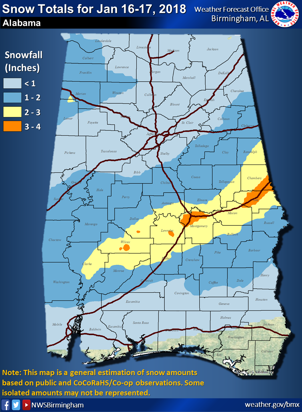
Obviously the location may be different, but the same general idea of a clipper with a little bit of gulf influence is the thing to watch.

AL_map.png
 
Obviously the location may be different, but the same general idea of a clipper with a little bit of gulf influence is the thing to watch.

AL_map.png
Didn't this storm start off as a clipper than ended up with a gulf low?
 
Obviously the location may be different, but the same general idea of a clipper with a little bit of gulf influence is the thing to watch.

AL_map.png
That one was a heartbreaker. I was living in Birmingham at that time, and all the Mets we're calling for 3 to 4 inches of snow.
 
gfs_ref_frzn_seus_12.png
Gfs trying to spin a low? Could get some nice snow showers in the mountains
 
At this point, I'm rooting for a rogue teen low... 22 is still the coldest recorded temp at CHA officially. That's borderline a record, I think. Warmest cold season low.. Will have to look it up.
 
Back
Top