Geez no wonder...


And is that an 850 low I see?

And is that an 850 low I see?
That looks a lot like the nam at 12zGefs keeping heavier storms south
View attachment 34893
look like there should of been more snow in the upstate especially in the western section is it to warmLast map from the nam. Storm is still going for the eastern half of nc.

rain line pushing north

Yea I guess being in union county always concerns me when I see mix line down in LancasterNo. It's pretty much where it was before. Once again, we are sitting pretty good here now. Notice how the bullseye shifted? Being in the bullseye this far out is NOT a good thing.
Yea I guess being in union county always concerns me when I see mix line down in Lancaster


We are so close to seeing something much bigger you think 3k nam will do better with temperatures profile than 12k


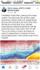
Is that mean it’s snowing hard in the upstate trying to learnHere are some maps that are better, yeah those are boatloads of frontogenesis, my goodness View attachment 34987View attachment 34988
Thursday into Thursday night.... maybe early Thursday in your areaSo what is the general timing of this event, Thursday afternoon/evening or is it more of an overnight event? Or is it all too early to ask.
Sent from my Z983 using Tapatalk
Okay, well early Thursday doesn't sound too good due to daytime heating. I hope it holds off until after 12-2pm in that case.Thursday into Thursday night.... maybe early Thursday in your area

How far are they off byCould be much more in the upstate if we ca get those temps fixed!View attachment 34993
View attachment 34981
temps during the middle of the event, I imagine if those temps were to hold for the Midlands, we’d have more than just rain falling.


I think right now it's showing mid-day or so but as happens time and time again, don't be surprised to see it arrive earlierOkay, well early Thursday doesn't sound too good due to daytime heating. I hope it holds off until after 12-2pm in that case.
Sent from my Z983 using Tapatalk
Overall, NAM runs have trended warmer for North Georgia. Looking less and less like an event for North Georgia/ Metro Atlanta (outside of the mountains) but looking at these soundings, it's just so close. 2-3 degree change between now and then and we get widespread heavy accumulations. Is 2-3 degrees too much to ask for at this range? With a warming trend, it seems so,


Shoot me for "wishcasting" but I got to think it could be more if the ICON verified just because it's usually too warm with temps but either way that's nice right there, real nice.
So close but hell it's 78 hours out. Maybe we can drop a couple of degrees between now and then and get a snow event. Definitely not out of the question given recent systems.I was looking at the sounding at hour 75 for the city of Atlanta....a damn warm nose between 800mb and 850 height is killing us.
Hour 78 might be a snow sounding...definitely at the very least mixed precip.
So close but hell it's 78 hours out. Maybe we can drop a couple of degrees between now and then and get a snow event. Definitely not out of the question given recent systems.

18Z ICON is almost identical to the NAM. Its just warmer so more qpf is rain.