-
Hello, please take a minute to check out our awesome content, contributed by the wonderful members of our community. We hope you'll add your own thoughts and opinions by making a free account!
You are using an out of date browser. It may not display this or other websites correctly.
You should upgrade or use an alternative browser.
You should upgrade or use an alternative browser.
Wintry February 19-21, 2020 Winter Storm
- Thread starter Six Mile Wx
- Start date
looks like a decrease.
NBAcentel
Member
D
Deleted member 609
Guest
12z JMA and Navgem look supressed too
I hope you end up correct. At this time though I have a hard time believing anywhere south of I40 see anything more than token flakes. It will be hard to overcome the surface temps the globals are showing. That's a wet bulb temp of 39 at CLT. Once the short range models come into range they'll probably be a little colder but probably not enough. I don't see how we get accumulating snow along 85 from GSP to CLT south and east.Right now I’d saw those in that purple region will get a wintery mix but there’s plenty of time for that to trend colder especially with so much high pressure moving in and appears to move in quicker. Those on the northern fringe in the light blue are fighting moisture issues but these things tend to trend NW and more moisture is showing up. Those is the darker blue in my opinion have the best shot for a winter storm. The high pressure is moving into a prime spot and you can see the buckling of isobars for the CAD regions as well. With moisture trending further north as well, these areas at this moment appear to have the best shot for something. Models won’t likely even begin converging on something until tomorrow around the 12z runs.
B
Brick Tamland
Guest
I think Wake County northeast to Norfolk will end up being the jackpot zone.Or, I'm hoping for a more expansive precip field. More amped and that could hurt folks down east and maybe even us.
snowlover91
Member
An interesting observation on how quickly a N trend can happen and precip can shift north. Look at the NAM for the system moving through the southeast today as modeled 81 hours out.

Now here is the NAM for 9 hours from the 12z run.

This goes to show how dramatic a N trend can be with the precip even inside 84 hours.

Now here is the NAM for 9 hours from the 12z run.

This goes to show how dramatic a N trend can be with the precip even inside 84 hours.
D
Deleted member 609
Guest
Ithinkhope Wake County northeast to Norfolk will end up being the jackpot zone.
Cadi40
Member
Let’s maybe try to keep wishcasting out of this thread?
iGrey_X
Member
Having to monitor the NAM on the phone and it’s a little tough to see everything but it looks good to me so far. The energy looks consolidated more and the trough looks further west
Blue_Ridge_Escarpment
Member
At the end of the NAM run, it has a 1050 HP in the Midwest ?
iGrey_X
Member
Agreed the NAM looked okay. No bad but not great either after getting on the computer.
iGrey_X
Member
However there is a 1050 HP and what looks to be CAD forming. We will see what comes of it later on.
Crow
Member
Can someone post the individual members for the 12z EPS? Long time viewer, first time poster here in N central NC. Hopefully we can reel this one in.
WxBlue
Meteorologist
While H5 on the Nam looked a tick worse, it is much colder
Maaaaybe a net positive? We definitely could use more cold.
Six Mile Wx
Member
iGrey_X
Member
H5 was slightly worse, not really much to harp on but the temperature swing is really what to take away as the 2m temperatures dropped 12-13 degrees across the upstate and I40 and I85 corridor in NC. The 850’s 0C line went from I40 down to the NC/SC border. That is telling that temperatures are likely going to continue be modeled lower. As time continue to gets closer.
Six Mile Wx
Member
baroowoofr
Member
Starting to wonder if this shortwave in the Pac has more to do with this than the N stream we've been watching:
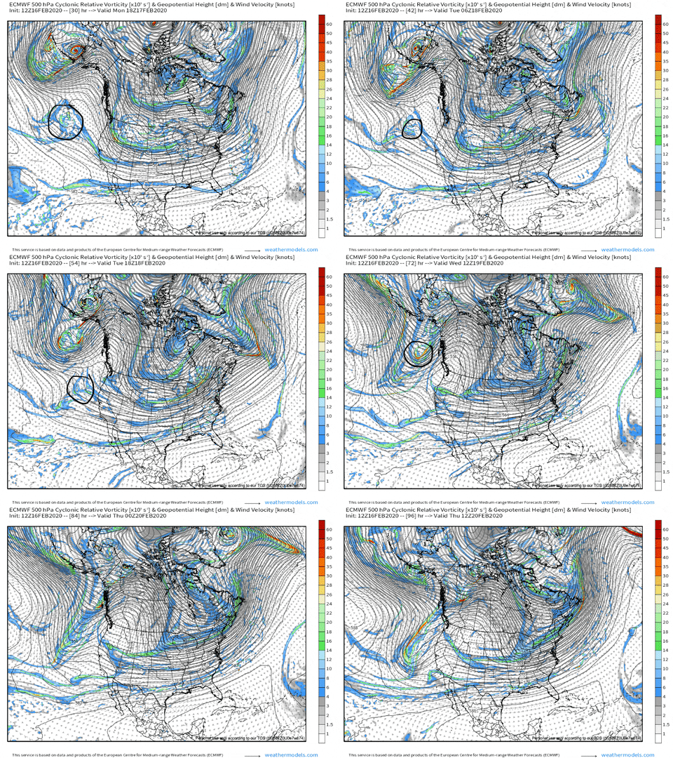
Euro swings it in underneath and N stream shortwave and squishes it while the NAM:
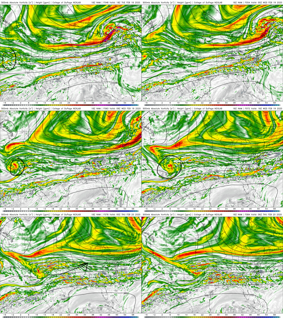
swings it out more intact.
Not saying the NAM will be right here, just that it is a touchy set up.

Euro swings it in underneath and N stream shortwave and squishes it while the NAM:

swings it out more intact.
Not saying the NAM will be right here, just that it is a touchy set up.
Starting to wonder if this shortwave in the Pac has more to do with this than the N stream we've been watching:

Euro swings it in underneath and N stream shortwave and squishes it while the NAM:

swings it out more intact.
Not saying the NAM will be right here, just that it is a touchy set up.
Maybe, and I'm stretching, the ECMWF has a bias to hold energy in the SW. Maybe that's allowing it to get caught up in the wave while the NAM moves it out.
baroowoofr
Member
Maybe, and I'm stretching, the ECMWF has a bias to hold energy in the SW
Maybe. Overall Euro does better with H5, but on a global scale. We're looking at a couple of waves in particular in an area of the hemisphere where, at least speaking for myself, I never really look to see how it does with this sort of a set up.
I could see it going either way. Maybe the N stream ends up verifying faster and Euro's squish happens. Maybe this wooly booger over the Pac packs a punch and muscles its way across the CONUS.
That second scenario, better for my area/ latitude, is probably not so good for areas further south, since to bring the moisture north, it has to get the flow out of the SW.
snowlover91
Member
pcbjr
Member
Outside of NC, with this, it's going to be tough ...
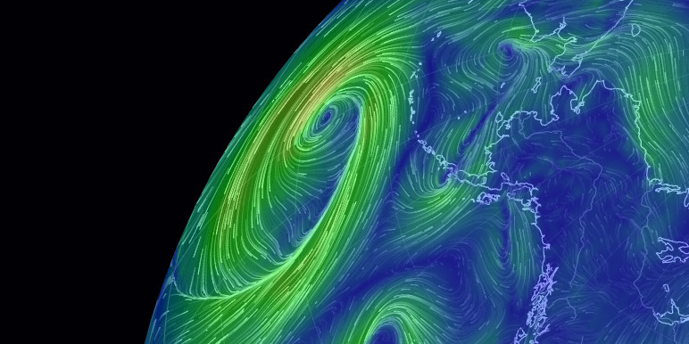
 earth.nullschool.net


earth :: a global map of wind, weather, and ocean conditions
See current wind, weather, ocean, and pollution conditions, as forecast by supercomputers, on an interactive animated map. Updated every three hours.

whatalife
Moderator
Just as a reference point here are the temps for 3 major models at 12z and the 18z Nam for Thur. at 06z. The Nam is a good bit colder...


Sent from my iPhone using Tapatalk


Sent from my iPhone using Tapatalk
That’s the ensemble sweet spot. It adds up18z icon with more of a cmc type enhancement in Eastern NC. First run of the icon showing snow.
View attachment 34729
Cadi40
Member
The one time I need the ridge to flex it’s muscles to move the precipitation back west and it’s no where to be found...
Cary_Snow95
Member
More wave interaction on the 18z GFS
packfan98
Moderator
Looks to be a slightly better push of colder air.More wave interaction on the 18z GFS
Cary_Snow95
Member
Starting to fall in line with the CMC/ICON/NAM suite.
Also on this run our driving shortwave is less amplified... our longwave is more extended into the energy under the ridge and overall slightly further west. 3 big setup changes = the setup/pattern is still volatile and big changes at surface could still occur going forward. Nothing set in stone yet!
Cary_Snow95
Member
Cary_Snow95
Member
Gfs has taken a significant step towards the cmc


