The precip frames haven’t loaded yet, but this looks interesting.


Sent from my iPhone using Tapatalk


Sent from my iPhone using Tapatalk


Yep we can’t look past threats like that any threat can trend in the short range and when we’re talking about CAD events it can always trend colder and in that case can turn out to be a bigger deal than we think out of no whereNext Saturday keeps trending colder n colder. Interested to see how this evolves next few days.
I have extreme doubts for that system. No other model but a couple members on the American suite show anything, plus that is relying on HP wrapping around a low around the Great Lakes.Yep we can’t look past threats like that any threat can trend in the short range and when we’re talking about CAD events it can always trend colder and in that case can turn out to be a bigger deal than we think out of no where
Yeah I was just looking over the members and I know it’s after hr 240 but there are some beastly members. Things just continue to look better let’s see how the EPS comes in it looked good earlier let’s see if they continue to get better as they figure out this progressive pattern.GEFS probably is going to look really good.
View attachment 30217View attachment 30218View attachment 30219
Agreed. Although I do believe that preliminary system will have big ramifications on the one behind it. I’d like to see areas as far south as VA get in on some ZR with wave #1I have extreme doubts for that system. No other model but a couple members on the American suite show anything, plus that is relying on HP wrapping around a low around the Great Lakes.

I would take that and cash out the winter. LmaoNothing crazy, lots of things I would like to see changed, but nice little event across Costal SE.
Sent from my iPhone using Tapatalk
Yes although chance is low all I am saying is we can’t lose sight of it cause sometimes these type of systems like to sneak up on us as we approach themI have extreme doubts for that system. No other model but a couple members on the American suite show anything, plus that is relying on HP wrapping around a low around the Great Lakes.


GEFS Mean:
Graphics 1 and 2 (Include Sleet) 330hrs
View attachment 30224View attachment 30225
More realistic snowfall Mean, that takes in only Snow.
View attachment 30226View attachment 30227


I wouldn’t call it a storm/large scale system yet, there’s still a big spread in timing so it’s just storms corresponding to the better pattern on ENS member ATM, there’s definitely a better pattern coming up tho, if there’s one signal, it’s a signal of CADJust took a peak at the Gfs ensembles for wave two ... good lord much more agreement there that a large scale system could be effecting the south east ... that looks like it could be the fun one we are going to be heavily tracking in the next week ... the big take away is the amount of support for a large system at the same time period grew substantially I would say
Now is an important time to look at the ensembles .. and if you look at the 06z GEFS ensembles .. you’d see why the operational is a blip for sureUgly GFS run this AM. Minimal cold. Must be a blip.
Sent from my iPhone using Tapatalk
Some of those members bring a lot of snow to the southeast. Still some meh members mixed in.Now is an important time to look at the ensembles .. and if you look at the 06z GEFS ensembles .. you’d see why the operational is a blip for sure


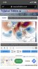
Legitimate tornado threat last night for Dallas Fort Worth area, this morning there is snow & sleet just NW of the city. Crazy stuff.


Wow gotta like that look. Nice ridge bridge over the top from Europe, through Greenland and Northwest territories and then down the west coast. If correct that is $$$