Well, maybe the GFS from the other day wasn’t so crazy after all ??Pac ridge nosing poleward is a big difference. The control run is a conus freezer.
View attachment 29097
 ..issa start
Well, maybe the GFS from the other day wasn’t so crazy after all ??Pac ridge nosing poleward is a big difference. The control run is a conus freezer.
View attachment 29097
..issa start
Still +AO/+NAO, mostly zonal flow, only thing looks better is the pac ridge nosing poleward as kylo mentionedAnyone got some 500mb from the eps post d10
Sent from my SM-G975U using Tapatalk

Really trying to squeeze the toothpasteStill +AO/+NAO, mostly zonal flow, only thing looks better is the pac ridge nosing poleward as kylo mentioned
View attachment 29100
Still +AO/+NAO, mostly zonal flow, only thing looks better is the pac ridge nosing poleward as kylo mentioned
View attachment 29100
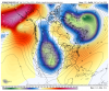
This still confuses me I think the models are still very very confused on the evolution of this pattern per these crazy different runs from run to run including their ensembles I definitely don’t believe people should be canceling anything with this much uncertainty but also I just remember Webber being consistent in saying if anything were in an El Niño year so I feel like if a La Niña type pattern try’s to set up it won’t have staying power or maybe it’s just down right wrong .. I think little jogs in the models can really put us in a good spot .. only problem is getting to that point but I think the euro eps put some light into the hope of thingI assume you know this but for those readers who don't, the exact opposite of what this shows would normally be much more conducive to SE cold, a trough near and south of the Aleutians since a ridge there often teleconnects with a -PNA and a trough there often teleconnects with a +PNA. Move the ridge eastward 1,000 miles and I think we'd be in business. Unfortunately that is way easier said than done.
What this is showing is a La Ninaish -PNAish look, which is favored by -AAM, which is predicted to dominate in early Jan. even though it is slightly + today and for the next few days.

Luckily we have that 50/50 low. EPS Control has some snow in the MA and some in NC. Bad pattern at H5, but cold 850's
View attachment 29102View attachment 29103View attachment 29104
One things for sure, when ridging finally builds into Alaska they’re should be be plenty of cold air on tap to send our way!
How did jan 12 end up
Like Jan 19How did jan 12 end up
How did jan 12 end up


I’ll cash in at this pointgotta admit, this is a weird map. View attachment 29111


I’m not looking to January of 2012 as an analog unless that pattern becomes lasting. The latest 0z run of the EPS shows that cold starting to head our way in a week from today.How did jan 12 end up
Looks a lot better! Now, if we could just get that Ridge over Europe to move towards Greenland to hold the cold in the south!FWIW here is the 10-15 00z EPS 500 height anomalies...
Sent from my iPhone using Tapatalk
FWIW here is the 10-15 00z EPS 500 height anomalies...
Sent from my iPhone using Tapatalk

Welcome to the SouthernWx weenie insane asylum! Great to have you a board.I'm Stephen and I'm also new to the discussion board. I enjoy the enthusiasm for winter weather on here. and weather in general. I've lived in NC for 39 years and I have seen warm days like the ones we are currently experiencing. It does make one wonder if winter makes a comeback. I honestly don't believe ( history tends to back this up) that we can go thru an entire winter without getting some sort of payback from mother nature. There is alot of cold air over Alaska/Siberia (-40 to -60F) and it has to get dislodged at some point. Now where exactly the core of this super cold air goes is up for debate, but do believe we can't go thru an entire winter and not get at least some snow/ice in the south. I'm model watching like y'all are, but let's give it time and be optimistic.
Sent from my SM-J727U using Tapatalk


Are you talking about the few days of the forecast? I wouldn’t trust it in the COD or anything outside Day 7 on the GEFS.
Check this out...(I know it’s not the bias corrected version but I didn’t have an old screenshot of that)we were supposed to be in the COD and we are obviously in a decent amplitude of phase 7 (map not updated yet)


The GEFS LR MJO diagram where the spread is increased as noted by the gray areas is notoriously terrible.
Sent from my iPhone using Tapatalk
Thus the bias corrected version. It’s been a couple runs in a row now that has reduced the amplitude in ph 5. That’s about the only thing I implied on that post.
I don’t think the BC version performs any better at low amplitude.
Also I’m more agreeing with you, drastic changes likely at the tail end of MJO phase diagram plots. So it’s a good thing.
Sent from my iPhone using Tapatalk


Your taking these MJO forecast to literally. EPS and GEFS are going to have large spread...though if that was your point then we are on the same page. My point and only point is the GEFSBC has trended less amp in ph 5 over past few days
View attachment 29131View attachment 29132View attachment 29133
Yes we call it the evil SER.The models have consistently shown polar air advancing toward the SE in the long range only to be stopped by the Ohio River. It's like there is a anti arctic force field set up there.


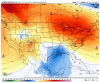
Really not easy to draw a much worse looking map than that.
And the Weather channel chiming in...
Sent from my iPhone using Tapatalk
Is this for January?
And the Weather channel chiming in...
Sent from my iPhone using Tapatalk
I guess they could paint the entire CONUS in that brown color.Really not easy to draw a much worse looking map than that.