Boy the gfs doesn't look bad the first few days of January
Indeed, the 12Z GFS has a colder than normal day 1/3 in the SE US into 1/4 AM. But is it believable? Freeze down to Macon and Columbia if this verifies 1/4.
Boy the gfs doesn't look bad the first few days of January


Yeah idk cmc kinda straddles the fence euro releases the closes low in the west. Could go either way reallyIndeed, the 12Z GFS has a colder than normal day 1/3 in the SE US into 1/4 AM. But is it believable? Freeze down to Macon and Columbia if this verifies 1/4.
Well 12z Canadian looks like the 0z euro with a big warm up ahead of the next front.Yeah idk cmc kinda straddles the fence euro releases the closes low in the west. Could go either way really
Sent from my SM-G975U using Tapatalk
GFS finally supports my thinking. Recognize the pattern first. Too far out to know the details of when but I think January will feature a winter storm west of the blue ridge.I believe the pattern continues to support snow west of the blue ridge (Louisiana-Tennessee) but less to none in the Carolinas. Wouldn’t be surprised to see a winter storm pop up in the extended for places like Mississippi/Alabama.

That would be a big dog look for Birmingham to Chattanooga to Knoxville. Too bad it’s in fantasy land. I still think that cold air in Alaska eventually comes crashing into the Eastern US in January and Opens up potential for most on here.GFS finally supports my thinking. Recognize the pattern first. Too far out to know the details of when but I think January will feature a winter storm west of the blue ridge. View attachment 28934


For you guys, I wouldn’t won’t to change the pattern to overwhelming cold that would get the Carolinas in play. You would be shooting yourself in the foot while east of the Appalachian divide becomes overwhelmingly favored. Keep the same pattern going and west of the blue ridge is going to get smoked by one or two. See members 3, 12 and 14 above.That would be a big dog look for Birmingham to Chattanooga to Knoxville. Too bad it’s in fantasy land. I still think that cold air in Alaska eventually comes crashing into the Eastern US in January and Opens up potential for most on here.
What a wild GEFS run
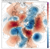
Yeah a strong 50/50 “wavebreak” helps the ridge to flex, creating a strong west based -NAO, altho I would really don’t know if thats exact with lower heights around central/northern GreenlandEuro nukes the PV and begins building ridging across the pole with the lobe over AK trending westward and ridging beginning to build over Greenland. Interesting to see what comes of that.
Yeah a strong 50/50 “wavebreak” helps the ridge to flex, creating a strong west based -NAO, altho I would really know if thats exact with lower heights around central/northern Greenland
preciselyPersonally, the NAO can do whatever. I really like seeing ridging build toward the pole from Asia. If we can get the low over AK to continue to build westward and flex the eastern Pacific ridge, a bridge across the pole would put us in the freezer.
Euro nukes the PV and begins building ridging across the pole with the lobe over AK trending westward and ridging beginning to build over Greenland. Interesting to see what comes of that.
Personally, the NAO can do whatever. I really like seeing ridging build toward the pole from Asia. If we can get the low over AK to continue to build westward and flex the eastern Pacific ridge, a bridge across the pole would put us in the freezer.
Personally, the NAO can do whatever. I really like seeing ridging build toward the pole from Asia. If we can get the low over AK to continue to build westward and flex the eastern Pacific ridge, a bridge across the pole would put us in the freezer.


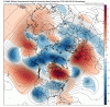
if we can keep those lower heights off the SE coast we should be money for a seasonal January. Overall not a lot to work with here but I’ve seen worse in the past 10 years. Plus it doesn’t take crazy anoms to catch the tail end of a retreating high to score something east of the mountains.Here's the last panel on the 18z GEFS. I don't hate it.

TPV parked over there gonna help around the artic

Cross Creek? We need to get together for a round some day! Have fun and Merry Christmas!!! Can't believe this winter is looking and probably going to be horrible again. Will we ever have another great winter?
has something to do with Alaska being so cold maybe?Freeze 1/6 to Gulf coast per 0Z GFS.
Flurries/light snow deep into the SE with the cold plunge. @pcbjr high only in 40s with upper 20s next morning! Winter’s revenge?
Edit: And note that the origins of this airmass are actually largely Pacific I think. This shows how with a deep enough quick plunge, the SE can still get pretty cold even when the airmass isn’t primarily Arctic in origin.
has something to do with Alaska being so cold maybe?
Hopefully if that cold is coming into the NE, maybe a well timed high can help set up a CAD stormGood thinking but looking again more closely, it appears the Alaskan bitter air comes down into the Midwest and NE with the follow up cold front, the one that cools the SE back down somewhat but only with a glancing blow.