Webberweather53
Meteorologist
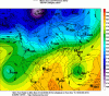
One thing I've noticed right away in the short range w/ recent runs of the GEFS/GFS is the tendency for our shortwave over the North Pacific to trend weaker as verification nears and it is also losing latitude in the process.
This gives an edge to the weaker, less enthused, & more suppressed ECMWF/EPS camp in the longer term. I think some of this also has to do w/ the GFS being underdone on the Great Basin/Rockies ridge in the short range, effectively causing our trailing s/w over the Pacific to weaken as it has to lift and lose some relative vorticity passing thru stronger s/w ridge axis out in front of it over the western US.
However, beyond this point, there's still a ton of confounding variables & moving pieces left to resolve and we're still 3 days away from said wave actually being adequately sampled by North America RAOBs which may or may not have a significant impact on the eventual forecast of this system late next week.
.gif")
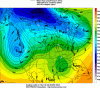
This gives an edge to the weaker, less enthused, & more suppressed ECMWF/EPS camp in the longer term. I think some of this also has to do w/ the GFS being underdone on the Great Basin/Rockies ridge in the short range, effectively causing our trailing s/w over the Pacific to weaken as it has to lift and lose some relative vorticity passing thru stronger s/w ridge axis out in front of it over the western US.
However, beyond this point, there's still a ton of confounding variables & moving pieces left to resolve and we're still 3 days away from said wave actually being adequately sampled by North America RAOBs which may or may not have a significant impact on the eventual forecast of this system late next week.


.png")

.png")
.png")
.png")

.gif")