-
Hello, please take a minute to check out our awesome content, contributed by the wonderful members of our community. We hope you'll add your own thoughts and opinions by making a free account!
You are using an out of date browser. It may not display this or other websites correctly.
You should upgrade or use an alternative browser.
You should upgrade or use an alternative browser.
Pattern The Great December Dump
- Thread starter Rain Cold
- Start date
NBAcentel
Member
yeah, GEFS has mean SCPs of 2-4, which is pretty high for a ensemble mean, right now things are looking a little unidirectional, but that wind shear is gonna be pretty strong, and cape is gonna be thereMeanwhile something to watch from DOC
DISCUSSION...
Medium-range guidance remains in relatively good agreement that a
shortwave trough will move from the Great Basin into the
southern/central Plains on D4/Sunday, continuing through the mid MS
Valley and into the Upper Great Lakes on D5/Monday. Guidance differs
on the location of the surface low associated with this shortwave
trough, with current forecasts of its position at 12Z D5/Monday
ranging from the KS/OK/MO border intersection to central TX. Even
with these differences, consensus is good for a moist and moderately
unstable environment from the Lower MS Valley through the TN Valley
on D5/Monday ahead of the approaching shortwave. Strong vertical
shear will extend across this region, supporting long hodographs and
supercell wind profiles. Consequently, there is a threat for severe
thunderstorms D5/Monday afternoon and evening from the Mid-South
into the Lower OH Valley as the shortwave trough and associated cold
front move through. Forecast confidence is high enough to introduce
severe probabilities. Refinements to this area are likely in
subsequent forecast as mesoscale details become more apparent.View attachment 27844

whatalife
Moderator
The EPS don’t have a clue and are caving slowly to a more colder solution...


Sent from my iPhone using Tapatalk


Sent from my iPhone using Tapatalk
What on earth is a west based -NAO? That must be before my time.
It’s a -NAO where the highest heights are to the west.
Sent from my iPhone using Tapatalk
Our pattern in week 2 is trending in a direction that resembles the GEFS cold temperature bias & thus will temporarily mask the underlying issues w/ the model of late around here.
View attachment 27838
The EPS in the 11-15 has obviously been too warm across nearly the entire CONUS.
View attachment 27837
Where did you find these great maps?
Folks, note that in the area from DC SW to N GA, the GEFS cold bias has been the strongest in the entire US while there’s been a pretty strong WARM bias over the Rockies/inter mountain west. This is consistent with the idea that the model itself doesn’t have a consistent cold bias everywhere because much of the bias is instead a pattern bias consistent with a +PNA bias in the means.
OTOH, note that the EPS warm bias is more of a classic warm bias vs the GEFS cold pattern type of bias since this EPS warm bias covers nearly the entire country. But also note that the EPS warm bias doesn’t include most of the SE with even a small cold EPS bias in the far SE consistent with the idea of the tendency of a not strong enough forecasted SER in the means.
Curious to see how this Dec pattern evolves...kind of extrapolating it looks like it could be one of our better Dec patterns since 2010. Can't recall the last Dec or winter month for that matter that had low heights off the east coast.


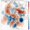
“Models continue to struggle beyond 5-6 days lead, with the operational models seeing the largest change from yesterday’s 12z run to this morning’s 0z in the 6-10 Day period. The GFS OP gained ~20 GWHDDs, while the Euro OP gained ~14 GWHDDs. The Maxar forecast gained +7.1 GWHDDs over the course of the next 15 days, and +6.1 GWHDDs of the cold change occurred in the 6-10 Day period. There is still room for additional model volatility, and this is echoed by the widening spread of solutions among members of the Euro EN in the Midwest. In St. Louis, the spread among members increases to more than 20° for the average temperatures on Day 7 and is 35° (range from 9°-44°) on Day 8. Similar spreads are in Chicago...”
“The spread is not only wide within the Euro EN, but sizable differences between models also exists. About 12 GWHDDs separate the colder GFS EN from its Euro counterpart. The upper air maps below show where the difference between models originates. The Alaska region will be the area to watch in future model runs, as the colder GFS EN has more ridging here and downstream south displacement of the polar vortex. Alternatively, the Euro EN has more troughing near Alaska and a faster shift warmer from west to central North America under a stronger Pacific influence.” from Maxar
“The spread is not only wide within the Euro EN, but sizable differences between models also exists. About 12 GWHDDs separate the colder GFS EN from its Euro counterpart. The upper air maps below show where the difference between models originates. The Alaska region will be the area to watch in future model runs, as the colder GFS EN has more ridging here and downstream south displacement of the polar vortex. Alternatively, the Euro EN has more troughing near Alaska and a faster shift warmer from west to central North America under a stronger Pacific influence.” from Maxar
IMHO, and could def. be wrong here, but I think EURO is trying to show us that there is some potential with that system.Uh huh. More separation and stronger blocking.
Storm5
Member
I’m all in on the Chicago snow Monday
Sent from my iPhone using Tapatalk
Sent from my iPhone using Tapatalk
Storm5
Member
Don’t look now but the GFS might try and pop a system Tuesday /Wednesday that ARCC has been mentioning
Sent from my iPhone using Tapatalk
Sent from my iPhone using Tapatalk
Storm5
Member
Don’t look now but the GFS might try and pop a system Tuesday /Wednesday that ARCC has been mentioning
Sent from my iPhone using Tapatalk
Up until the energy gets strung out and the western ridge goes to hell
Sent from my iPhone using Tapatalk
Here comes the solstice system....let's see what we get looks like it shouldn't be able to NW but temps might be an issue
Sent from my SM-G975U using Tapatalk
Sent from my SM-G975U using Tapatalk
Dang that cinnamon bun in SE canada ruins things
Sent from my SM-G975U using Tapatalk
Sent from my SM-G975U using Tapatalk
Honestly better trends though .. big Canadian high with some true cold air is now aroundDang that cinnamon bun in SE canada ruins things
Sent from my SM-G975U using Tapatalk
GFS continues to be active across the SE. Very good for continuing to beat back the remaining drought conditions. Hopefully, the active pattern will continue as we transition deeper into winter and evolve to better high latitude support.

The storm around the 21st takes a great track, but we're not getting help farther north. While winter weather is possible, we're still in a period where super timing is needed. We need that PV lobe to scoot east and remain suppressed ahead of the storm. Coming in with or behind the storm effectively blocks our cold air feed, as shown on the 12z run.
The storm around the 21st takes a great track, but we're not getting help farther north. While winter weather is possible, we're still in a period where super timing is needed. We need that PV lobe to scoot east and remain suppressed ahead of the storm. Coming in with or behind the storm effectively blocks our cold air feed, as shown on the 12z run.
It’s a -NAO where the highest heights are to the west.
Sent from my iPhone using Tapatalk
Oh I know. Just thought they were extinct.
My bad. I thought you forgot what one was since it's been years.Oh I know. Just thought they were extinct.
")
Don’t look now but the GFS might try and pop a system Tuesday /Wednesday that ARCC has been mentioning
Sent from my iPhone using Tapatalk
Definitely trending the right way. Biggest problem I see right now is that is some very dry air being pumped in from the northwest.
Attachments
The CMC looks a bit interesting at the end of its run.

Ethan80963!
Member
With as far south as the CMC has it this is where you would want it to be this far out in case it wants to go NW. That is if it stays on modelsThe CMC looks a bit interesting at the end of its run.
Way more separation on the 12z Euro.
Look at that bowling ball off the west coast at 162The CMC looks a bit interesting at the end of its run.

Gonna be too strung out to do anything.
The old rule of Nino thumb, where it exits at the same latitude it enters, will hopefully hold serve here.Look at that bowling ball off the west coast at 162View attachment 27870
True and probably will just not as a bowling ball but a jacked up strung out good for nothing mess....The old rule of Nino thumb, where it exits at the same latitude it enters, will hopefully hold serve here.
How
How about ‘wherever it enters, it still finds a way up the apps or into the lakes’!???The old rule of Nino thumb, where it exits at the same latitude it enters, will hopefully hold serve here.
SnowNiner
Member
When? Where? Why? Dang it twitter!

Moved over here. Not every day you get to move a post from Whamby to the Big Show!Curious to see how this Dec pattern evolves...kind of extrapolating it looks like it could be one of our better Dec patterns since 2010. Can't recall the last Dec or winter month for that matter that had low heights off the east coast.
View attachment 27856View attachment 27857View attachment 27858
The Euro doesn't look bad. It has a system, Its just way too suppressed. extremely deep 50/50 low


B
Brick Tamland
Guest
True and probably will just not as a bowling ball but a jacked up strung out good for nothing mess....
Nah, not this time. We're going to score a storm right before Christmas.
Yeah, it's cold but dry:The Euro doesn't look bad. It has a system, Its just way too suppressed. extremely deep 50/50 low

I'll take that D10 look everyday and twice on Sunday.... and still no torch!The Euro doesn't look bad. It has a system, Its just way too suppressed. extremely deep 50/50 low
The EPS still no Bueno

packfan98
Moderator
I will say that I think the 12/21-12/22 period is a legitimate threat. Almost every run of the GEFS and EPS has shown the potential with a decent setup for the past several days. Almost every member of the GEFS has the system. A couple of days ago some of the members were leaning towards a warmer aps runner. However, the blocking has been improving as well as the PNA. Now some of the ensembles and operational runs are suppressing and squashing the system! Experience tells me its just about everything we look for with a potential system. Cold air will always be an issue in the south, but it feels right to me. Let's see how it trends the next few days.
pcbjr
Member
Every one of these looks pretty good as of today's runs : https://www.cpc.ncep.noaa.gov/products/precip/CWlink/daily_ao_index/teleconnections.shtml
EPO is doing us no favors:https://www.esrl.noaa.gov/psd/map/
but 4 out of 5 ain't bad ...
EPO is doing us no favors:https://www.esrl.noaa.gov/psd/map/
but 4 out of 5 ain't bad ...
BHS1975
Member
I'll take that D10 look everyday and twice on Sunday.... and still no torch!
Yeap need room for that nw trend!
Sent from my iPhone using Tapatalk
Yeah, it's cold but dry:
Need that trough axis to come in further west at least to have a shot. We will see
View attachment 27879
The timing of that 50/50 low and a S/W would need to be just right. If a deep 50/50 low comes into places first, a storm system would likely not form. Perhaps one would form after the 50/50 low kicks out, but then it would probably warm ahead of a S/W. A 50/50 can mean a significant east coast snow storm (SECS) but there's no guarantee. If an SECS occurs, bombogenesis can occur far south as the Mid-Atlanic.The Euro doesn't look bad. It has a system, Its just way too suppressed. extremely deep 50/50 low
I have a feeling that time frame is right for something to possibly occur as well. I haven't seen enough consistency for my liking - consistency is your friend. The pattern does though look like something good could happen for that time though.I will say that I think the 12/21-12/22 period is a legitimate threat. Almost every run of the GEFS and EPS has shown the potential with a decent setup for the past several days. Almost every member of the GEFS has the system. A couple of days ago some of the members were leaning towards a warmer aps runner. However, the blocking has been improving as well as the PNA. Now some of the ensembles and operational runs are suppressing and squashing the system! Experience tells me its just about everything we look for with a potential system. Cold air will always be an issue in the south, but it feels right to me. Let's see how it trends the next few days.
Sent from my SM-A102U using Tapatalk