• Hello, please take a minute to check out our awesome content, contributed by the wonderful members of our community. We hope you'll add your own thoughts and opinions by making a free account!

Tropical Hurricane Dorian

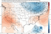
Icon takes it down into the Florida straights and actually tip toes around the peninsula! Heading for the Gulf of Mexico for a potential strike on the northern Gulf Coast?

This has got to be southern most outlier of models. Waiting for the Euro...
 
Wonder how soon the G-4 can start getting data on high strength and orientation into the models. That's gonna be the last opportunity for any major changes I would think, but the models have missed this storm pretty badly so far. I mean a hispaniola approach to over the virgin islands is a couple hundred miles for a 2 or 3 day forecast. Dorian went well outside of it's short term cone from a couple days ago.
 
icon_mslp_pcpn_watl_60.png
 
Uh oh. 12z GFS puts my area in the game with a major. Looks like the Gulf coast needs to keep an eye on Dorian.

Sent from my SM-G950U using Tapatalk
 
ICON way south, GFS the farthest north. Do you go with the Euro in the middle?
 
Uh oh. 12z GFS puts my area in the game with a major. Looks like the Gulf coast needs to keep an eye on Dorian.

Sent from my SM-G950U using Tapatalk
That's the ICON. The GFS is headed straight towards the space coast this run.
ICON way south, GFS the farthest north. Do you go with the Euro in the middle?
I think it'll head exactly where the GFS is as of right now, but beyond that I can't guess.
 
I have mostly stayed out of this thread because I don't really have anything new to add. But my gut tells me this will miss the US. Also, I don't trust the Icon with tropical systems.
 
Based on what? Lol
His gut.... and I really don't want anymore details about his gut. Lol

Anyway... GFS has landfall late Sunday night/early Monday morning, Wednesday morning it's still in south Ga. Goodness let's hope not, no one needs more massive inland flooding
 
In the meantime, you can see on San Juan radar and with reports of SW winds in St. Croix the center is clearing that island to the north and is still well east of PR.... also still looks to be on a NNW heading.
 
It's pretty freaking incredible that just 24 hours ago we were wondering how well it would survive interaction (if at all) with Hispaniola and now it's outer most rain bands will probably never even make it there.
So gonna do more harm than good for those in the severe drought. Hopefully PR still gets decent rains especially the south side. This was the perfect storm for rain since it wasn’t too strong like Maria.
 
This is a particularly dangerous tropical storm being added to a short list of names that can strengthen in the graveyard of the eastern Caribbean and fool the NHC in the short term track. If it’s erratic behavior continues as a major hurricane I fear for the Bahamas and US.
 
Back
Top