Snowflowxxl
Member
My school just called telling all students to take shelter for a tornado warning, yet Atlanta is not even in the polygon. Guess they don’t know that a polygon doesn’t mean all of the County
Man you got your wish. I’m under a tornado warningI hope we just see lightning in GA with this. Highly doubt we see any severe.
Yea I was big wrong. Not afraid to admit that. Storm is intense for sure.Man you got your wish. I’m under a tornado warning

Been extended into Habersham county and southwest Rabun county now.Tornado warning: Southeast White county and Northeast Hall county GA.
 (((
(((
Yep and I still have concerns with those cells down east ahead of the main event. I'm very concerned someone could deal with a tornadic cell early only to follow up later with that QLCS with 70+ mph winds. What a day ahead of usThis just looks nasty in the Triad: View attachment 19222
Dang sorry to hear that, heckuva way to start the day.Well I woke up to intense lightning and rain. My den is ground level and water was coming through the freaking north wall covering the laminate flooring. My wife began to clean that up and I was outside in ankle deep water, in the lightning and pouring rain with a shovel trying to get the water to run off. First time this has ever happened in 17 years of living here. Oh yea roof was leaking in the kitchen so I have some roof damage. Did not expect this much rain so quickly.
This is definitely one of the most favorable large-scale environmental soundings you'll ever see in central NC for straight line wind damage and is definitely capable of support sfc wind gusts in excess of 75 mph (as noted by SPC).
View attachment 19221

Tornado warning just west of Athens GAView attachment 19223


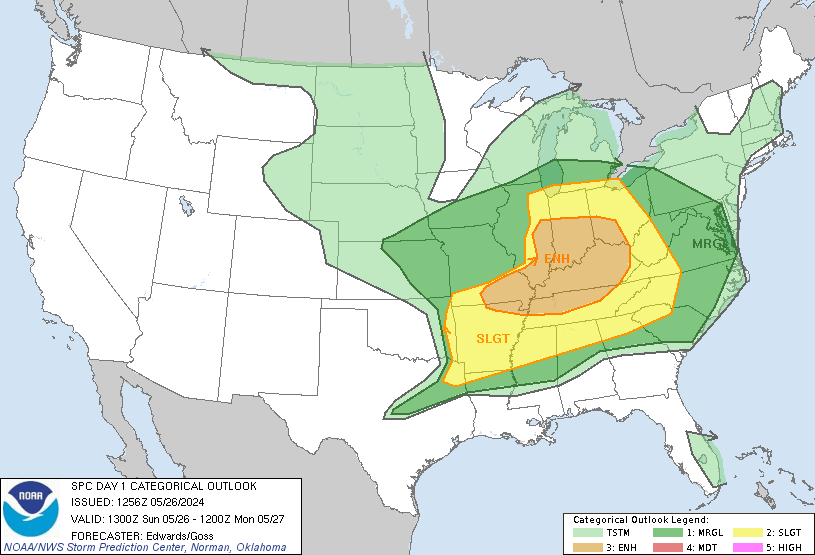
Virtually all of central NC is under a moderate risk of severe weather for the first time since Feb 2016. Hopefully people are taking this one seriously
View attachment 19219
This is definitely one of the most favorable large-scale environmental soundings you'll ever see in central NC for straight line wind damage and is definitely capable of support sfc wind gusts in excess of 75 mph (as noted by SPC).
View attachment 19221
From Rah NWS, this is serious....
Environmental conditions ahead of the front look dangerous to say the least, with efficient enough instability (1000 - 1500 J/KG ML CAPE), dangerous shear (Bulk: 45 to 55kts; SFC -> 1km: 20 - 30kts) and helicity values, and near record PWat values (1.6 inches +). In terms of limiting factors, few exist, other than the uncertainty of just how much surface heating will be allowed throughout the day, however, with such a strong WAA regime in place, the atmosphere should be allowed to destabilize pretty efficiently without many breaks in the sunshine. The environment looks prime for a very active and potentially destructive weather day across the Carolinas.
Sent from my SM-G950U using Tapatalk

And so of course we get a second line with tornado and flood warnings all night long. Another great job by Glenn.Guess that’s that. View attachment 19215
Uh oh CC dot on this storm now. Confirmed tornadoTornado Warning in Florida southwest of Tallahassee.View attachment 19227

And so of course we get a second line with tornado and flood warnings all night long. Another great job by Glenn.