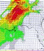
• Hello, please take a minute to check out our awesome content, contributed by the wonderful members of our community. We hope you'll add your own thoughts and opinions by making a free account!

Severe March 9-10 Arklatex/Lower MS Valley/Gulf Coast Severe threat

Weird sounding, lapses are ok, SFC-based CAPE is ok, shear is strong but what has my attention is low level instability/lapses, 200 jkg of 3CAPE ?, pretty steep low level lapse rates, good moist layer (SFC-700 hPa) decent hodo, very low cloud bases, high helicity, this sounding could actually support a violent tornado but it’s very hard to find soundings similar to these, this is from northern-central Arkansas
C8D762B6-5CE7-4A6E-BDA9-95C10EAD41DC.png
 
Here’s one from northern MS, not a crazy tornadic sounding but dang my goodness that hodo and helicity
DB0EC885-3128-4E65-9BAA-B3330110090D.png
 
Ruh roh
day2otlk_0700.gif
 
It's hard to tell now if the enhanced area is the SPC playing it safe after not having an enhanced area last weekend with the tornado outbreak, or if it's a legit enhanced threat.
I doubt last weekend has anything to do with it at all. IMHO, the SPC creates their forecasts and graphics based on their best understanding of what the weather is most likely to do. It would be foolish to do anything else.
 
SPC was perfect last week the enhanced risk over the area. Nothing supported going any higher than they did at the time.
 
Okay, I thought they only had a slight risk. Personally, I think the marginal and slight categories, and the enhanced and moderate categories sound the same.
 
the HRRR, looks impressive but doesn't show storms firing up in the zones that have the best parameters
 

Attachments

  • 20190308_102030.jpg
    20190308_102030.jpg
    1 MB · Views: 28
  • 20190308_102053.jpg
    20190308_102053.jpg
    863.6 KB · Views: 27
Here’s a sounding from the end of the Hrrr for the areas with higher SPCs/STPs, note the skinny CAPE, lackluster 3CAPE, sfc-3km lapses suck, what looks like a weak stable layer near the sfc developing, still good wind energy/helicity but it’s definitely not a strong tornado sounding, more of a isolated spin up type of sounding 5841CB23-F0C2-41ED-9CCE-F4922296A014.png
 

Attachments

  • B0E83593-EC2B-4ABF-A5FD-15B901057B4A.png
    B0E83593-EC2B-4ABF-A5FD-15B901057B4A.png
    1.1 MB · Views: 27
First time in a while I don’t really agree with a SPC outlook. Wouldn’t be suprised if they shift it some more tonight.
 
Agree. Looks like overall better dynamics getting pulled north with the departing slp... also short range also picking up the warm front getting further north .... bit

Agree, if y’all can manage to get some instability, then oof, best lift/forcing appears over western TN, please hope for no sun and no discrete supercells or strong tornadoes are possible if those 2 things occur, hope for linear convection, so much wind energy/SRH around there aswell
 
Thing is tho is that other parameters are quite nasty but also so far there are things holding this back, 3CAPE is lacking a lot you can actually see a very weak Cap/EML, nicely moist column, strong SRH/shear, decent SBcape
B5850C94-F10F-431E-95C7-976BB1578683.png
 
Looks like low topped supercells/cold core tornadoes or hail may possibly occur in eastern KS tommorow afternoon since there will be decent CAPE/3CAPE, steep lapse rates and a low equilibrium layer, cool dynamic system to say the least, weather is truly interesting
643D9340-4DA2-42D6-B3FC-9485C7594065.png
 
I want to also note that the hrrr has been trending to these storms looking less surface-based and a tad more elevated, struggling with CAPE in the lower levels
 
Back
Top