Not a bad little shift there....

Sent from my SM-G950U using Tapatalk

Sent from my SM-G950U using Tapatalk
Luckily I’m headed back to Fayetteville tomorrow, definitely stand a decent chance to get some flurries Tue morningJust close enough to keep me curious....
Sent from my SM-G950U using Tapatalk
Soundings are interesting got a little lift in the 700-850mb layers and some saturation in the dgz. Wouldnt be surprising to see some virga around tuesdayJust close enough to keep me curious....
Sent from my SM-G950U using Tapatalk
I want some flurriesLuckily I’m headed back to Fayetteville tomorrow, definitely stand a decent chance to get some flurries Tue morning
Too much wedge for thunderstorms, too little wedge for snow. Stuck in rain cold purgatory till May. Just fantabulous.
Eh we might erode the wedge just enough we get a little interesting weather tonightToo much wedge for thunderstorms, too little wedge for snow. Stuck in rain cold purgatory till May. Just fantabulous.
The 3k gets close.Eh we might erode the wedge just enough we get a little interesting weather tonight
Sent from my SM-G955U using Tapatalk
This one seems DOA.
Wow thought that was the end of the run... say it ain’t ... SNOW?!
Lol anyways that should be rain on the hrrr, not snow

It would be all snow but we need moisture and there’s none here

Sent from my iPhone using Tapatalk

So, you want the silent treatment, huh? ... LOLIf anyone here doesn’t think that 0.8” accumulation in central GA is fake news, please reply.
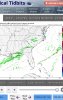
The thunder rule? Lmao0z ECMWF had a few isolated rain/snow showers generally along a corridor from about Montgomery, AL to Macon, GA, Columbia, SC and Fayetteville, NC.
You'd still get snow out of that sounding just not big fluffy dendrites.Yep, thats what I meant, no moisture in the snow growth zone so a cold light rain, we’re so good at thatView attachment 17259
The thunder rule? Lmao
You'd still get snow out of that sounding just not big fluffy dendrites.
Sent from my SM-G955U using Tapatalk
Me either. Looking at the 0z nams there is a little saturation in a couple of layers and some lift but nothing crazy. HRRR might be over done a little but I wouldn't be shocked to see a little virga around.ehhh, I dont like the LR hrrr at all but we’ll see
The thunder rule? Lmao
The thunder rule? Lmao
NWS Birmingham reported snow about 3 hours ago so that "rule" already verified there lol
So, the new rule is 7 hours afterward instead of 7 days afterward?
I'm waiting just a few more minutes to see the 0Z EPS for Monday night before saying night night.
So, the new rule is 7 hours afterward instead of 7 days afterward?
I'm waiting just a few more minutes to see the 0Z EPS for Monday night before saying night night.

Hey @Webberweather53 due you think Tuscaloosa and Birmingham have a shot at some flurries if the moisture moves more north in AlabamaFFC considering adding some flurries to the forecast for middle GA.
Will be seeing an exiting weak system of low pressure as the
extended portion begins. With colder temps in place during the
morning, came close to adding some flurries in but moisture does
not appear to be sufficient enough at this time to support.
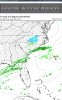
EPS shifted the precip NWward, back to where the 0z suite was last night.
Arguably the most impressive EPS suite yet.
Reel it in @deltadog03
I definitely stand a chance of getting something down in Fayetteville Tue am
View attachment 17269
FFC considering adding some flurries to the forecast for middle GA.
Will be seeing an exiting weak system of low pressure as the
extended portion begins. With colder temps in place during the
morning, came close to adding some flurries in but moisture does
not appear to be sufficient enough at this time to support.


.gif")
