• Hello, please take a minute to check out our awesome content, contributed by the wonderful members of our community. We hope you'll add your own thoughts and opinions by making a free account!

Pattern Marvelous March

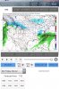
I think there is pretty good agreement right now on a possible system of interest in the March 2-5 period. The Fv3 has one (no surprise), the Euro is close to something and GEFS/EPS members have been showing some interest in this time as well. The blocking looks pretty solid too and if it verifies close to what is being modeled we may have a shot. Here's the main models of interest.

Fv3

View attachment 16182

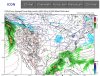
The GFS has a storm at this same time as well but with a different 5h look.
View attachment 16184

The GEFS has a solid signal too.
View attachment 16186

Finally the EPS also has a weak low moving off the coast.
View attachment 16187

The storm in December is the only other time we have seen this much buzz from different models at the same time. We finally have some other models supporting the FV3 with a storm signal.
 
I believe Eric was trying to say that the pattern modeled on the Euro would support snow even if we were in mid to late March, not necessarily that it will last that long.

Exactly, it's the type of pattern which if it presented itself in late March or April for instance is the only one that could probably deliver any hope of snow. If you're worried about the air not being cold enough to support wintry weather, this is the pattern you want to have because it usually becomes more about moisture at that point which this year has had plenty of.
 
The Pacific is just relentless this year. +PNA has zero staying power. Wave after wave hitting the west coast. Story of the season
Agreed. BUT... what the sitrep up north looks like makes a big difference in the potential outcome. If you look at just the PNA region in the Euro48 and the Euro240, they look similar:

EuroCombine.jpg

Now, if we zoom out and take a look over the top, there's the secret sauce. At 48, have a system moving along in the STJ, causing the PNA to dip negative. But we got no block, a PV that's way north, and a raging SE ridge. Guess what happens next:

48 Final.jpg

Congrats on your blizzard, Minneapolis!

ecmwf_z500_mslp_namer_4.png

Looking down the road at 240, we have another system coming along in the STJ (although not shown to be as vigorous as the one at 48), causing the PNA to dip negative again. But we have the big block, a southeastward displacement of the PV, and no SER to speak of. The storm track is forced south.

240Final.jpg

After the systems move through, the PNA bounces back. Short wavelengths. Bottom line is, I'm fine with a negative or neutral PNA IF the reason is that it's a temporary artifact of an active STJ AND IF there is a pattern over the top that can make use of the activity in the STJ, like the one shown.
 
Pattern Outlook: I’m going with a sig. Miller A in March as winter comes to a close. I think the NC mountains will benefit with a heavy wet snow. If I was wrong anywhere in my late winter outlook (for those that have been following me) it will be that the mountains above 3,000ft do now have a chance of a 6”+ snowfall. Outside of the mountains there is a chance for 1-2 light to mod. winter weather events that will struggle to reach warning criteria. There will be nothing for April outside of the highest peaks. I think Spring will feature some summer like heat and people will think Spring was skipped for a month or so. Some CAD and precip will return in the summer after June 1st. Hurricane season will feature less rainfall for NC and no direct hits. Watch the Gulf boys.
 
Yep, nothing except a monster +PNA, huge PV diving down and a shortwave south. It’s too far south and the PV might be a little strong but this is our chance right here

0a9abea5c396f136fa022564c08332a1.jpg

a515afabca92d1411af221b3c77c183b.jpg

b6bf0a537ffec736f87dc7b07d91efab.jpg


So close to something epic for N.C. at least. The EPS should be fun.

Sent from my iPhone using Tapatalk

That is a way to raise eyebrows.
 
The 18Z GFS has nothing even close to a SE winter storm nor a freeze at ATL through 3/6. Yawn. I'm starting to get a bit less hopeful about early March. We'll see. I mean if many runs are showing me air not even cold enough to get ATL down to 32, it is very hard to get excited.
 
Last edited:
The 18Z GFS has nothing even close to a SE winter storm nor a freeze at ATL through 3/6. Yawn. I'm starting to get a bit more skeptical about early March. We'll see. I mean if many runs are showing me air not even cold enough to get ATL down to 32, it is very hard to get excited.

I’m not worried about the gfs tbh, 12z/18z will look the same then change at 00z, it’s pretty inconsistent at ranges 180+, when ensembles are showing this inside a better range its wayyyy more likely (image I posted earlier) B3930B52-F9DA-4507-8EDF-BAD324FC7738.jpeg
 
Folks it’s several days away models will struggle with a pattern change. This is a snow pattern if I ever seen one esp for the NC mountains. Easily one big dog and maybe 1-2 smaller events that include the Greensboro to Charlotte corridor. I’m not buying any ice or miller b for now.
 
Folks it’s several days away models will struggle with a pattern change. This is a snow pattern if I ever seen one esp for the NC mountains. Easily one big dog and maybe 1-2 smaller events that include the Greensboro to Charlotte corridor. I’m not buying any ice or miller b for now.

Threat of miller B transfer/CAD is increased with a -EPO pattern, sure we may get lucky with a miller A but a miller B is much more common and anticipated with a -EPO
 
I’m not worried about the gfs tbh, 12z/18z will look the same then change at 00z, it’s pretty inconsistent, when ensembles are showing this inside a better range its wayyyy more likely (image I posted earlier) View attachment 16198

You being in NC means you have a much higher chance than many others here. That sounds great but the fact of the GEFS and EPS consistently having had strong cold biases whereas the GFS doesn't is a bit worrisome as far as buying what the ensembles say. Will they even show anything resembling what you illustrated on that 204 hour map? I know you realize this. Plus even the ensembles are not doing anything more than getting marginal cold into the SE and not even cold enough for many like ATL in many cases.

I'm still getting that mirage feeling when I look at the models.
 
You being in NC means you have a much higher chance than many others here. That sounds great but the fact of the GEFS and EPS consistently having had strong cold biases whereas the GFS doesn't is a bit worrisome as far as buying what the ensembles say. Will they even show anything resembling what you illustrated on that 204 hour map? I know you realize this. Plus even the ensembles are not doing anything more than getting marginal cold into the SE and not even cold enough for many like ATL in many cases.

Oh yeah you live in a area farther south, damn, what the models were depicted a few days ago with the -NAO, better ridging over Greenland, that would of helped areas out even farther south by causing a bigger pv lobe displacement right ?
what the gefs looked like when we had the -NAO/-AO days ago, now it’s more of the big -EPO/+PNA25DA06ED-7320-43A5-B100-0E96D45AFCEC.jpeg
 
The 18Z GFS has nothing even close to a SE winter storm nor a freeze at ATL through 3/6. Yawn. I'm starting to get a bit less hopeful about early March. We'll see. I mean if many runs are showing me air not even cold enough to get ATL down to 32, it is very hard to get excited.

Has KATL had a freeze during the month of February so far?
 
No, coldest is 34. With no freeze expected, Feb of 2019 will have had the highest lowest of any Feb on record back to 1879. The current warmest coldest for any Feb is 33. So, something interesting to track.

That was my next question, so there was a year where there was no freeze recorded, at least with 1879 instrumentation. You're a wealth of information about this area, much appreciated.
 
18Z GEFS: signal for 3/4-5 Miller A with a far SE track that would normally even get my interest way down here but it just isn't nearly cold enough/no good cold air connection to do any good. Remember that storm from a few weeks ago that was well offshore that gave only far SE GA/coast some rain
with middle 40s (not nearly cold enough) and that some in NC were upset about missing them? At best that's how this looks on this run. A great track, alone, is far from sufficient to get the job done. And with the strong GEFS cold bias on top of that, it is hard to get excited even with this kind of track showing up.

Bottom line: we need stronger cold coming down further. Being near the dividing line is fine, but we (especially those south of N NC-TN) still need it to be quite a bit colder and not just this very glancing cold that has been the case so often this winter. The recent trend of the models has not been to bring the cold down further. If anything, it has been the opposite,
 
Last edited:
18Z GEFS: signal for 3/4-5 Miller A with a far SE track that would normally even get my interest way down here but it just isn't nearly cold enough/no good cold air connection to do any good. Remember that storm from a few weeks ago that was well offshore that gave only far SE GA/coast some rain
with middle 40s (not nearly cold enough) and that some in NC were upset about missing them? At best that's how this looks on this run. A great track, alone, is far from sufficient to get the job done. And with the strong GEFS cold bias on top of that, it is hard to get excited even with this kind of track showing up.

Bottom line: we need stronger cold coming down further. Being near the dividing line is fine, but we (especially those south of N NC-TN) still need it to be quite a bit colder and not just this very glancing cold that has been the case so often this winter. The recent trend of the models has not been to bring the cold down further. If anything, it has been the opposite,

This one is a bit interesting aswell, but it looks like temps would be a bit of a issueCB10D38A-ACE6-453F-8470-9B0885A05A96.jpegE5069BB3-FE08-4F90-B2A3-B8EFECB367D9.jpeg6CC40D87-A992-4C32-A110-4C5075E1DD1A.jpegE9B00EDB-F471-42DC-8092-0C40DDEE1F56.jpeg
 
Well, my prediction of the weeklies weeks 3-6 for the SE was dead on as they say winter is over by March 9. They’re warmer than normal with strong E US ridging (yuck) and there’s no -AO and no -NAO. Considering the cold model
bias, this suggests the last chance for winter is the first week of March.
RC took the wrong week off from his typical warm as heck guessing.
 
I think we are well on our way to a great March indeed ... nothing wrong with tonight’s GEFS they haven’t gotten anything correct all year but the euro is way colder than GFS and continues it and has been correct all winter with the warm ... way more positivity coming from this pattern than the other one ... lots of storms to go hopefully

Especially in NC very favored
 
Well, my prediction of the weeklies weeks 3-6 for the SE was dead on as they say winter is over by March 9. They’re warmer than normal with strong E US ridging (yuck) and there’s no -AO and no -NAO. Considering the cold model
bias, this suggests the last chance for winter is the first week of March.
RC took the wrong week off from his typical warm as heck guessing.

So, I can expect a cold March going by the past.
 
So, I can expect a cold March going by the past.

Lol.
I wish I could say that with seriousness, but the cold bias tells me otherwise. They’ve almost always been too cold and not the other way around. But who knows this time? Maybe Mar will still be miraculous?

I think we need a cooler Atlantic for the future.
 
Hopes for early March magic just about gone outside the upper south and mountains unfortunately unless we get some favorable trends. The major positive is that we hopefully lose the atmospheric river over many of us.


Sent from my iPhone using Tapatalk
 
Lol.
I wish I could say that with seriousness, but the cold bias tells me otherwise. They’ve almost always been too cold and not the other way around. But who knows this time? Maybe Mar will still be miraculous?

I think we need a cooler Atlantic for the future.

You can't broadbrush the model as having a cold bias in the extended and assume that's going to apply in virtually every case especially when the upcoming period in early March is going to be a lot colder than what was forecasted a few runs ago on the weeklies
 
Im hearing the weeklies look very warm for much of March. I even saw someone on the other forum mention March 2012. Hopefully it wont be that warm.
 
Im hearing the weeklies look very warm for much of March. I even saw someone on the other forum mention March 2012. Hopefully it wont be that warm.

Honestly if it’s not going to be cold with a shot at snow I say bring on the warmth. That way I can get outdoors and start enjoying spring! Plus my kids love being outside and the cold, damp, muddy weather is tough on them since they can’t go play outside when it’s like this.
 
No, coldest is 34. With no freeze expected, Feb of 2019 will have had the highest lowest of any Feb on record back to 1879. The current warmest coldest for any Feb is 33. So, something interesting to track.

CHA also looking to end the month of February with warmest minimum on record as well with 30...tied with 1882 and 1932.
 
Lol.
I wish I could say that with seriousness, but the cold bias tells me otherwise. They’ve almost always been too cold and not the other way around. But who knows this time? Maybe Mar will still be miraculous?

I think we need a cooler Atlantic for the future.

Lol maybe cooler south of Greenland from all the melting otherwise it’s a steady rise to bath water temperatures in the future. You think the SER ridge is bad now just wait


Sent from my iPhone using Tapatalk
 
GFS also has a 1056 mb high drilling down at the same time ... setting up hopefully a cold pool for the NEXT storm to work with ... ? ALL IN
 
36 hours latter, Sunday snowing again most TN into extreme northern AL, MS, heading east.

Sure all this will be around at 6z lol.
 
FWIW 0z Icon show incoming Major ice and snow in Carolinas at the end of the run.
 

Attachments

  • 81B7E942-55A2-48FF-BC21-68EAB786CE1A.jpeg
    81B7E942-55A2-48FF-BC21-68EAB786CE1A.jpeg
    1.2 MB · Views: 56
Back
Top