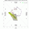
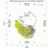
The MJO propagation still appears favorable over the next couple of weeks:


Both the GEFS and the EPS continue to show a solid -EPO and a trough in the central and eventually the eastern US, although they vary somewhat in the details. The D9 GEFS shows the block oriented in such a way that the flow backs around it toward the west and eventually the trough retrogrades and connects to the trough out in the Pacific, destroying the pattern.

The EPS is oriented more so that the flow is out of the north, producing a better, probably longer lasting favorable pattern (although I can't see past D10 right now):

The STJ remains alive and active as you can see by the D10 24 hour total GEFS precip map:

Temps at 850 are below normal across much of the country. This propagates eastward down the line. GEFS:


EPS:


At D9, the GEFS mean 2m temp profile looks like this:

It trends colder for the next few days. I don't have one for the EPS, but I assume it has a similar, and probably slightly colder progression. I would not put a lot of stock in model D9 2m temp progs, but the point is, it will likely be below normal. The STJ will remain active. High pressure will continue to build in and track across the country. That is about as good as we can ask for at this point.
The daily SOI contrib is -27. The EPS is still split on the typhoon recurve. The GFS is all in on it. The NAO and AO continue to look like garbage on the GEFS, so if it's right, we'll have to take a -EPO neutral/slightly +PNA and make the best of it. I don't have visibility into the EPS past 240, but given the MJO progs, we have about 2 more weeks, unless a big -NAO suddenly shows up.


Both the GEFS and the EPS continue to show a solid -EPO and a trough in the central and eventually the eastern US, although they vary somewhat in the details. The D9 GEFS shows the block oriented in such a way that the flow backs around it toward the west and eventually the trough retrogrades and connects to the trough out in the Pacific, destroying the pattern.

The EPS is oriented more so that the flow is out of the north, producing a better, probably longer lasting favorable pattern (although I can't see past D10 right now):

The STJ remains alive and active as you can see by the D10 24 hour total GEFS precip map:

Temps at 850 are below normal across much of the country. This propagates eastward down the line. GEFS:


EPS:


At D9, the GEFS mean 2m temp profile looks like this:

It trends colder for the next few days. I don't have one for the EPS, but I assume it has a similar, and probably slightly colder progression. I would not put a lot of stock in model D9 2m temp progs, but the point is, it will likely be below normal. The STJ will remain active. High pressure will continue to build in and track across the country. That is about as good as we can ask for at this point.
The daily SOI contrib is -27. The EPS is still split on the typhoon recurve. The GFS is all in on it. The NAO and AO continue to look like garbage on the GEFS, so if it's right, we'll have to take a -EPO neutral/slightly +PNA and make the best of it. I don't have visibility into the EPS past 240, but given the MJO progs, we have about 2 more weeks, unless a big -NAO suddenly shows up.


![14-km EPS Global United States 5-d Avg T2M Anom [C] 300.png 14-km EPS Global United States 5-d Avg T2M Anom [C] 300.png](https://southernwx.nyc3.digitaloceanspaces.com/data/attachments/16/16181-08c861341ac70cd64352b132ce9b906d.jpg)


