-
Hello, please take a minute to check out our awesome content, contributed by the wonderful members of our community. We hope you'll add your own thoughts and opinions by making a free account!
You are using an out of date browser. It may not display this or other websites correctly.
You should upgrade or use an alternative browser.
You should upgrade or use an alternative browser.
Wintry January 29th-30th ARCC Slam Dunk Winter Weather Threat
- Thread starter ForsythSnow
- Start date
WXinCanton
Member
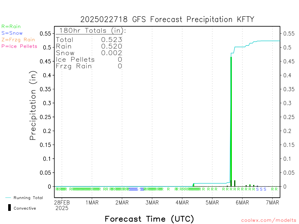
Text data from 12z GFS This is from Charlie Brown airport.
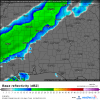
Friendly reminder.....Thats showing green because there isn't enough moisture in the snow growth region to actually snow. it comes down as some drizzle/light rain. yes it will freeze on contact with temps below freezing.look how screwed up the euro is..that isn't rain on the back side...can't believe a thing it shows
View attachment 14080
That happened here in Baton Rouge during the storm system on 1/17/18. Rain changing to snow by 4pm, but moisture got scoured out by 8pm. Result was it was just tiny ice pellets near the end.Friendly reminder.....Thats showing green because there isn't enough moisture in the snow growth region to actually snow. it comes down as some drizzle/light rain. yes it will freeze on contact with temps below freezing.
Sent from my SM-G950U using Tapatalk
Text data from 12z GFS This is from Charlie Brown airport.
Let’s hope Lucy is not giving false hope to Charlie Brown airport.
Not to rain on anyone's parade wrt the GFS & GEFS but...
I think I'm gonna start saying, "oh look there is pony" every time one of those maps are posted.
Shouldn't it show it in pink then? I have never heard of this until now.Friendly reminder.....Thats showing green because there isn't enough moisture in the snow growth region to actually snow. it comes down as some drizzle/light rain. yes it will freeze on contact with temps below freezing.
Some do and some don’t.Shouldn't it show it in pink then? I have never heard of this until now.
accu35
Member

look how screwed up the euro is..that isn't rain on the back side...can't believe a thing it shows
View attachment 14080
OK one more time. That isn't rain on the back side. In fact it isn't anything on the back side. That is an 6 hour QPF map with precip determined by the temp taken at the time the image was produced.
And
Oh look a pony.
Snowflowxxl
Member
Atlanta now in a WWA. Northern counties in a WSW
look how screwed up the euro is..that isn't rain on the back side...can't believe a thing it shows
View attachment 14080
Just to quote this post again. That above is a QPF map, the one below is simulated radar and radar with precip type overlay.
Attachments
Flurry
Member
Definitely juicing up...
RollTide18
Member
Euro gives MGM 1/2 inch, I’ll take that all day everyday.
Fountainguy97
Member
Euro gives MGM 1/2 inch, I’ll take that all day everyday.
A lot of areas look good to see 1-3 hrs of light/mod snow falling.
Definitely a huge win for a lot of areas! Enjoy it guys!
LovingGulfLows
Member
- Joined
- Jan 5, 2017
- Messages
- 1,499
- Reaction score
- 4,100


Euro gives MGM 1/2 inch, I’ll take that all day everyday.
Euro is two to three inches here. If that happens I'll be pleasantly surprised.
Fountainguy97
Member
You can see the system shaping up nicely now.
The front is easily visible and looks healthy. You can easily make out the energy down in the GOM that will enhance the band across Mississippi/Alabama.
It’s time to now cast guys! Radar is lighting up in a few hrs! Enjoy the ride and don’t let the frustration of “it could be more” ruin a nice little snow tomorrow!
RollTide18
Member
Euro is two to three inches here. If that happens I'll be pleasantly surprised.
Same, looking at the correct rain/snow map, it seems to give a nice 90 minutes of snow/slush.
It would have to be more than light/mod snow to accumulate 2-3" in a 2-3 hour time frame wouldnt it ?A lot of areas look good to see 1-3 hrs of light/mod snow falling.
Definitely a huge win for a lot of areas! Enjoy it guys!
ATLwxfan
Member
Isnt it kind of late in the game to be looking at the Euro and GFS ? Wouldnt short range models be more accurate at this point ?
We don’t really like what the short range models are showing and prefer whichever model is calling for the most snow.
Sent from my iPhone using Tapatalk
Storm5
Member


Sent from my iPhone using Tapatalk
15z SREF plumes out if anyone is interested: https://www.spc.noaa.gov/exper/sref/srefplumes/
15z SREF plumes out if anyone is interested: https://www.spc.noaa.gov/exper/sref/srefplumes/
Bham is up to 1.88 from 1.75 in the mean. Has a 6 inch total too. A lot more big members
ATLwxfan
Member
I think most mets will go climo here as they probably should. It rarely snows. It almost never snows substantially when cold chases moisture. The models as stated are all over the place but no model is forecasting a big event.
Sent from my iPhone using Tapatalk
Sent from my iPhone using Tapatalk
Snowflowxxl
Member
Not out for ATL yet, although the QPF went down for sure.
- Joined
- Jan 5, 2017
- Messages
- 3,796
- Reaction score
- 6,038
Looks like .66 for the mean.My phone won’t load them what’s it show for ATL
Snowflowxxl
Member
SREF down significantly for ATL
RollTide18
Member
I don’t know what’s going to happen at this point, models going up, models going down. It really is nowcasting time.
LovingGulfLows
Member
- Joined
- Jan 5, 2017
- Messages
- 1,499
- Reaction score
- 4,100
SREF is a precursor to the NAM right? Could mean the 12km has trended towards it's high-res counterpart, the 3km.
Until the snow starts falling, there isnt really much nowcasting to do. We still need the models to pinpoint when the changeover is going to occur and how much moisture will be left. Besides, without the models, what else is left to discuss ?
Snowflowxxl
Member
Yesterday the SREF went way up and NAM went down, so idk.SREF is a precursor to the NAM right? Could mean the 12km has trended towards it's high-res counterpart, the 3km.
Funny its snowing northern obx on radar. The storm we chased and had like 70 pages of thread, actually produced some flakes for one county in the SE that probably has 20 people living there year round lol.
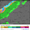
You can see the Alabama Smasher on radar rolling into NW TN at the moment. Good luck to you guys. Be sure to post some pics
You can see the Alabama Smasher on radar rolling into NW TN at the moment. Good luck to you guys. Be sure to post some pics
ForsythSnow
Moderator
I remember there was an event a bit similar to this but much faster back on March 3, 2016. It seemed to be similar in fashion as it started off as rain and then where rates got heavier, there was moderate snow. I remember it put down a quick half inch of snow and then the sun came out and melted it all. I expect this event to be similar, but there being less rain out front and there also being more snow. I also expect a few patches to remain in shaded areas into Wednesday morning.
Guys, we need to keep banter and friendly conversation in the forum that has been made for this. I just got done moving 30 post in the last 5 pages.
Thank you
Thank you
Snowflowxxl
Member
NAM looks badddd for a lot of us
GeorgiaGirl
Member
NAM says cancel the warnings and advisories outside of a strip in south central MS and SW AL, and that the RGEM led the way.
I'm sure that the long range models have it down.
I'm sure that the long range models have it down.
ForsythSnow
Moderator
I'm tossing this piece of garbage. Completely disgusting.

olhausen
Member
The models have been showing this for a few Days I believe. For some reason it seems the moisture is decent before Nashville but then putters out and reforms as it goes south and east of Nashville. I keep hoping we somehow over perform like the 2003 January storm that was only forecasted to bring an inch or so and dropped 7 on Nashville. I wasn’t living here so I have no idea how similar this storm is to that one but this is nothing but wishful thinking on my part anyways.Just kinda of a question. There looks to be more moisture on radar than the models are showing.. does this mean anything or am I just looking at it wrong ?
I wouldn’t worried about this. This is going to be a lot of a nowcast type of event.NAM looks badddd for a lot of us
Heck nam didn’t even iniate correctly.
Current radar.

Nam start off.
