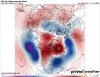
Man, where you been? All these indices pointing to the greatest winter ever in the southeast! Even the unicorn-NAO! What’s your thoughts? Are we losing the -NAO on the models already?
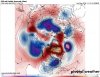
Losing the -NAO? We’re about to have a strong -NAO/-AO. Who cares if it temporarily rises back up in 2 weeks? They’re cyclical.


 In all seriousness I can’t wait to see this -NAO feature on the models in the next couple of weeks/months. It’s been a while. Should make for some epic 240hr clown maps even if it ends up raining

.png")
.jpg")