Kylo
Member
Ridge was solidly weaker this run and still tracked over ILM then up I95. Scary but hope a little more weaker to get off shore.
Yeah, he would be on the west "good side" of the storm as James Spann calls it.At least it’s not the right front quad. Big difference.
Sent from my iPhone using Tapatalk
All I ever wanted from Flo, was her rain!! You can keep the slight breeze!That's 25 miles from my house
Sent from my SM-G955U using Tapatalk


While we do have sampling from the storm itself, we still need to wait for the upper level data before we can really figure out what's going on. Not sure, but I wonder if sampling the storm only and the run making it stronger and resulting in an unsampled environment ahead could have made this run further north or south than if it had already been sampled. That's why I'm waiting for 0Z so we have both variables sampled before drawing this as a stop to a trend.


Yeah looks like it drifts SW between 168 and 192Florence stalls right over central & eastern NC for 3-4 days on this Euro run, flooding will be the main issue here...

So we get 80+ winds followed by a foot of rain..... you couldn't draw up a more catastrophic situation, it's wrong got to be wrongYeah looks like it drifts SW between 168 and 192
Sent from my SM-G955U using Tapatalk
Yeah looks like it drifts SW between 168 and 192
Sent from my SM-G955U using Tapatalk
So we get 80+ winds followed by a foot of rain..... you couldn't draw up a more catastrophic situation, it's wrong got to be wrong
Maybe it's just me, but I've noticed that tropical system tracks tend to trend NE over time on the models. If the Euro went from Charleston to Wilmington in one run that bodes well for this thing to continue to trend OTS. I think this option is very much still on the table for this storm. This storm may end up being different in this respect but I guess we shall see.I've got to stop thinking I can let my guard down.... dang it, need this to continue to trend north and east as in ots
In concurrence w/ Forsythsnow, I wouldn't call this a trend until we actually get upper air sampling around Florence. Tonight's 0z runs should be intriguing.
I quit taking measurements after a foot because I was getting the trees off my house.... yeah it was a conservative estimate on my part, figured it would be much more. Catastrophic either way man, poopA foot of rain? Oh there's a lot more than 1 foot of rain on this Euro run, already seeing 18" totals thru 180 HR on weathermodels and the storm has a few more days left to spin around and just dump.
I quit taking measurements after a foot because I was getting the trees off my house.... yeah it was a conservative estimate on my part, figured it would be much more. Catastrophic either way man, poop
It’s just one run of 3 models! No need for panic over the bullseye rain totals or wind fields 5 days out! Lots of changes yet to come! If your in the 24” of rain bullseye on Wednesday, then pandemonium can commence!

Well that’s 3/3 all global models are NE of previous runs .
Sent from my iPhone using Tapatalk
Yep the hwrf is bound for FL/GA


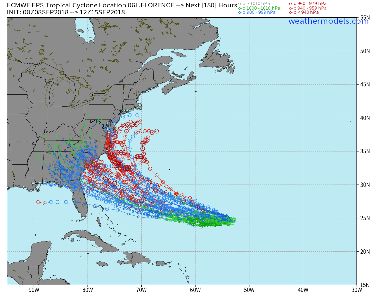
Seems to be just a bit south on average of the guidance, but some members seem to be clustering around the OP so far.EPS through 84
View attachment 6001

Basically from Fl to ots but seems to be a significant cluster around SC/NC border in that area