Webberweather53
Meteorologist
Seeing numerous reports of snow in/around Columbia, SC has to be on your doorstep
Yep its snowing in ColumbiaI wonder if Shawn and whatalife are getting something?


I'm glad your getting to see some snow. Thanks to you and Webber for all your hard work. I enjoy your guys analysis you provide for North Carolina.
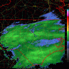
Obviously I want to add more but I'll call this a mic drop on winter
Sent from my SM-G928V using Tapatalk


Sweet, looks like nice band still over you too...congrats!
Obviously I want to add more but I'll call this a mic drop on winter
Sent from my SM-G928V using Tapatalk


Ugh, I'm getting shafted right now w/ moderate precip to my north and south. Smh typical Fayetteville.

Per the NWS this will be one of 17 times it's snowed in Columbia since 1888.....
Sent from my iPhone using Tapatalk
Hmm, it's definitely snowed a lot more than that in Columbia, SC. I've easily counted well over 100 events there since then
Hmm, it's definitely snowed a lot more than that in Columbia, SC. I've easily counted well over 100 events there since then
I'm starting to think a quick change to snow with the big East Coast storm isn't impossible for usAppetizing April?
Sent from my iPhone using Tapatalk
Lol.... btw look at the back edge of the precip trying to ring some moisture out of the atmosphere and guess what it's working... I have a full on flizzardThat moment when you realize the models are an hour later now
Sent from my SM-G928V using Tapatalk
This is the actual quote.... I figured it was directed towards the month of March.
NWS ColumbiaVerified account @NWSColumbia
Light snow at the Columbia Metro Airport! Today will count as 1 of the 17 times it has snowed in March since 1888. #scwx
Hmm, it's definitely snowed a lot more than that in Columbia, SC. I've easily counted well over 100 events there since then

Okay, in March, I see. Yea I was scratching my head for a second there lol
Nice! That last little band looks goodLol.... btw look at the back edge of the precip trying to ring some moisture out of the atmosphere and guess what it's working... I have a full on flizzard
Sent from my SM-G920V using Tapatalk
Lol.... btw look at the back edge of the precip trying to ring some moisture out of the atmosphere and guess what it's working... I have a full on flizzard
Sent from my SM-G920V using Tapatalk
Yeah for a fleeting minute it almost reached light snow category haha but it's over now and I see thinning clouds just to my north....pulling for you, that band to your west looks goodNice to see you actually have snow up there
This is from my parents house in sanford. Might end up looking like this your way soonNice to see you actually have snow up there

This is from my parents house in sanford. Might end up looking like this your way soon

Sent from my SM-G928V using Tapatalk
Yeah for a fleeting minute it almost reached light snow category haha but it's over now and I see thinning clouds just to my north....pulling for you, that band to your west looks good
Sent from my SM-G920V using Tapatalk