Still have 48 hours hopefully it will back off on ramping upStill have 48 hours. I need this bad boy as amped as possible

Sent from my SM-G920V using Tapatalk
Still have 48 hours hopefully it will back off on ramping upStill have 48 hours. I need this bad boy as amped as possible
Gulf Coast is asking alot for flurries but its very possible. But if you travel an hr north then different ball gameLocal mets in Mobile and Pensacola finally mentioning possibility of flurries along the gulf coast.
Wow, look at that jackpot zone. Nice! There's never room for error when it comes to winter storms here. We usually ride the line between nothing and a decent event.There is hope but also no room for error lol

Sent from my SM-G920V using Tapatalk
Well hell let's ride it like we stole itWow, look at that jackpot zone. Nice! There's never room for error when it comes to winter storms here. We usually ride the line between nothing and a decent event.
What you meant to say was " I would not feel too confident in any significant snowfall atm south of Boston "

The euro loves trolling meThere is hope but also no room for error lol
Sent from my SM-G920V using Tapatalk
You think there may be a sharp cutoff in North GA ?Where you see the stream of moisture now, that's where the snow will be falling come Friday. (GA)
Euro actually looking better than the last run and showing the classic RDU jackpot zone again. It's been pretty consistent with that.The euro loves trolling me
Sent from my SM-G955U using Tapatalk
It did however shift NW some...The euro loves trolling me
Sent from my SM-G955U using Tapatalk
No, not really.Where you see the stream of moisture now, that's where the snow will be falling come Friday. (GA)
The euro loves trolling me
Sent from my SM-G955U using Tapatalk
Safe call lol. Hopefully more thoMaybe I can get a dusting out of this
Seeing some snow and maybe getting a couple of inches is more than enough to ask for this early in winter, though. Just glad to see the Euro staying the course.Most of that precipitation is a rain snow mix or even cold rain at times, just look at the max temps between 700 & 850 hPa in the height of the event... They go above freezing over Raleigh and this probably switches the precipitation over to rain/sleet/wet snow mix at best. You need to slash those totals printed out on the Euro by about 75% if you're along or south of the heaviest axis of snow on the 10:1 ratio map. NW of there it'll be closer to reality but still too high
I plan to stay silent on this whole matter.
Sent from my iPhone using Tapatalk
Showing the GFS of course lol
Here we go ATL!

I think there will be a sharp cut off in NW GA.You think there may be a sharp cutoff in North GA ?
I am thrilled with the trends...but not so thrilled with the NW cutoff on the precip shield. Hoping if this does come to fruition that it pushes northwest another 50-75 miles(which honestly, normally it does). We shall see! I don't think any of us expected this so early in the month though lol.
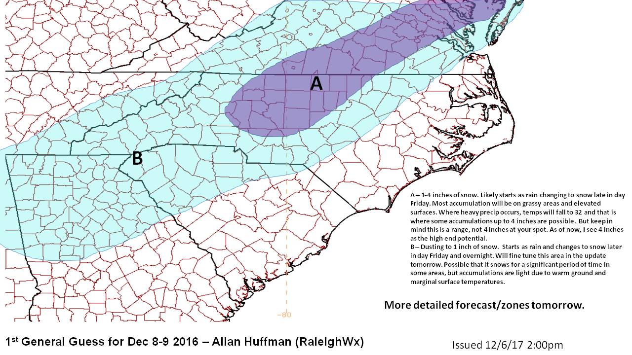
Seems reasonable, he has factored in lower ratios, makes sense, and the climo favored areas. I'd love to see it more SE but that would be wishcastingAllan Huffman's first guess. He knows the 2016 date is wrong.
For us central NC folks, nail in the coffin I'm afraid
Sent from my SM-G920V using Tapatalk
For us central NC folks, nail in the coffin I'm afraid
Sent from my SM-G920V using Tapatalk
Who's got the eps mean ?

For us central NC folks, nail in the coffin I'm afraid
Sent from my SM-G920V using Tapatalk
I can live with that
Oh no, maybe nail in coffin for me too

