RollTide18
Member
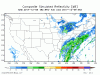
What is going on here????
Tropical Tidbit model output

Pivotal Weather Model Output at 84

Either TT is underestimating the moisture or PW is overdoing it.
What is going on here????
Tropical Tidbit model output
Pivotal Weather Model Output at 84
That is very strange looks like an algorithm issue with one of the sites.I guess it's just extremely weird
Yes it is per Pivotal... that's extremely weird to see TT and Pivotal showing different outputs like that
What is going on here????
Tropical Tidbit model output
Pivotal Weather Model Output at 84
I was wondering about that. I checked my area and the sounding showed a sharp dry slot in the mid levels, but otherwise was humid all above it.Tropical is showing precip reaching the ground. Pivot is showing composite which shows all levels of precip scans. Sounding inspection shows for places like north ATL, the precip is virga at this moment in time per this NAM run.
Hey Moto. Good to see you on here! Do you expect the precip to ramp up the closer we get?Tropical is showing precip reaching the ground. Pivot is showing composite which shows all levels of precip scans. Sounding inspection shows for places like north ATL, the precip is virga at this moment in time per this NAM run.
I was wondering about that. I checked my area and the sounding showed a sharp dry slot in the mid levels, but otherwise was humid all above it.
LOL....what do you use for JMA?Lol the JMA is a big dog
Well, all I have to say is its in the dumpster for me. Tell me how that can happen and I'll pull it out.Lol the JMA is a big dog

Hey Moto. Good to see you on here! Do you expect the precip to ramp up the closer we get?
Yeah it's really bad usually when a few days out. At least the Euro is giving us something. I would be surprised if it's more than a dusting at this point.I do expect things to tick up a bit. But I don't buy the NAM at all...yet... because is by far and away the worst of the guidance beyond 24 hours. I think I've only seen it lead once is sniffing out increased amplification.

More like for a day because it would be melted by the next.If we were to get 4 inches in pensacola, the city would be shut down for a month lol. Not gonna happen, it's almost 80 here today.
More like for a day because it would be melted by the next.
Unless there is a 2nd wave coming, not too excited about that look!

looked cooler to me than 12z... still crappy run...Everything is trending warmer
Yeah this run was colderlooked cooler to me than 12z... still crappy run...


Its funny because my area has showing good snow with the models. Location, SW Al.Spann just posted his latest blog- calling for a shot of light snow per Euro basically along and south I-59 till about Montgomery & points north and east to Atlanta.
Doesn’t expect much in the way of accumulation.