• Hello, please take a minute to check out our awesome content, contributed by the wonderful members of our community. We hope you'll add your own thoughts and opinions by making a free account!

Wintry Winter 2024-25 Discussion

18 inches of snow in Denver. I'm not sure when is the last time I saw that happen so early 👀
 
👀

As of Saturday morning, 19.3 inches of snow have accumulated at the Denver International Airport, more than double the 7.3 inches that Denver typically receives in November, according to the National Weather Service.

The deepest snow measurement across the state was 28 inches in Custer, Lincoln and Pueblo counties.
 
That would be great. You can see a little CAD signature as well. And if we can get more miller B type setups this winter we could tap into the la nina enhanced cold to our north. The miller B storms would get forced to redevelop off our coast and not run up the apps. At least that's what I'm hoping for..
 
This winter ought to be real interesting. Though I’m not as bullish on it being like 2013-14 as say a few months ago, there are still a lot of positives (& negatives too). I can see this being a hybrid/mixed bag of canonical -PNA and -EPO/+TNH at times. Not too confident on which way/how this winter is going to break/evolve. The -EPO/+TNH winters a lot of times buck the typical nina tendencies and are colder mid to late winter.

First real opportunity for legit cold probably comes sometime later in December or early January. By then, the MJO will have likely orbited back into the central pacific and western hemisphere.

Before then, likely in by early to mid December or so, we probably see some high latitude North Pacific blocking (-EPO) as soon as the MJO is entering the West Pacific. When this initially happens, I wouldn’t be surprised if this is accompanied by a SE US ridge
 
I still believe that this pattern upcoming is from the mjo getting into the colder phases for this time of year. That would be my assumption
 
Does that mean we go negative this year?
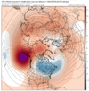
If this goes like I am thinking we probably will not get snow but could have some ice this winter. I'm thinking this winter will be roughly like 1998-99 IF LaNina arrives in time.
 
I know all is gloom and doom for winter weather lovers so far looking at long range forecasts and with La Nina taking over the weather pattern there seems to be little hope for a cold winter with plenty of precipitation for the Southeast. I'm just wishing for one winter storm to break the snow drought many of us are dealing with. At this point, it would be icing on the cake to get anything else to happen this coming winter.
 
From what I'm seeing this winter want end up being the most amazing one we had. But it also want be down there with the worst we've had either. I'm feeling more and more confident we strike a middle of the road cord here. Look at your climo averages and I think when its all tallied up by mid March, that's where we will shake out. Exception being qpf. I'd give the nudge to below normal. But temps, snow climo should balance out. Gonna get several swings on temps, both directions, but in the end the means will be smoothed out to close to average. The ground will whiten from something besides frost in the Triad this year. Write it down!
 
I stand by what I've said before.... Yeah I have very low expectations for this winter yeah I have possibly multiple snowy trips planned this winter if I have to but like there's no way it can possibly be any worse than the last two winters here. I mean we totaled about 3 hours of snow in back to back winters with snow holes around us on more than one occasion because we were 1 degree too warm with our climo and the final straw was when I came back from Colorado on February 21st this year and it was nearly 90 degrees here and never had another wintry anything.. Like no there's no way its gonna be that bad again. If it is serious questions have to be raised...

/End rant
 
The cadence of the MJO in autumn tends to carry thru the first half of winter. This autumn, the MJO has been running on a regular, predictable cycle. With that in mind, we should see the MJO on the left side of the diagram (7-8-1-2 in W Hemisphere) sometime within the late Dec to late Jan timeframe. Coupling that with a weaker Nina background (w/ -PDO) and a +QBO, which favors poleward N Pac ridging, should give us a thing or 2 to look at in that prime climo timeframe.

CFS for January has a reasonable look to it here

Nov 13 Jan CFS.png
 
The cadence of the MJO in autumn tends to carry thru the first half of winter. This autumn, the MJO has been running on a regular, predictable cycle. With that in mind, we should see the MJO on the left side of the diagram (7-8-1-2 in W Hemisphere) sometime within the late Dec to late Jan timeframe. Coupling that with a weaker Nina background (w/ -PDO) and a +QBO, which favors poleward N Pac ridging, should give us a thing or 2 to look at in that prime climo timeframe.

CFS for January has a reasonable look to it here

View attachment 154227
I personally feel like with a +qbo with higher solar, it usually supports a better chance at colder weather. People usually discount it. A pole ward aleutian ridge will promote the opportunity at a better delivery mechanism to bring cold south imo
 
The CFS is pointing towards the first week of December for a potential winter event. Maybe its on to something. It would at least be nice to have a cold pattern. And we've had some notable winter storms in early December.

Warning, banter image (CFS for ~Dec 7th):
1731616115426.png
 
A lot of times, the kind of cool ENSO winters that are warm in December and cooler in Jan-Feb in the conus, breaking the La Niña evolution mold, are predominantly +TNH/-EPO winters (Hudson Bay Vortex & Alaskan ridge).

A big reason why +TNH/-EPO winters this is that these types of winters with a big Hudson Bay Vortex in the troposphere tend to couple with the a cooler, stronger stratospheric polar vortex, which helps to reinforce & anchor the Hudson Bay vortex in place (via for ex, barotropic coupling processes and wave reflection). It certainly feels like this winter is headed in that general direction.

While we will certainly get our fair share of SE US ridging and -PNA, I think this winter leans more towards the +TNH/-EPO pattern overall, especially mid to late winter (tho even then we will still have a SE ridge overall).

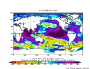
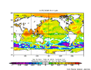
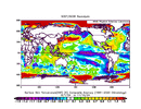
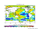
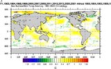
For example compare Global SSTa since September 1st to the Sep-Oct-Nov correlation patterns.

SSTa this year
IMG_3692.gif


SON SSTa correlation pattern for +TNH
IMG_3690.gif


SON pattern for -PNA

IMG_3691.gif

Key takeaways here:

- Current SSTa pattern is closer to the +TNH than the -PNA. The anomalous tropical West Pac and Indian Ocean warmth + weak, East-based La Niña stands out

-PNA is more closely linked to ENSO intensity (-PNA favored in stronger La Ninas), with no real signal in the West Pacific. -PNA is also more favored with a cooler Indian Ocean. The cooler Indian Ocean quells convection there, which takes westerly momentum out of the Pacific Jet downstream, shifting the centers of action to the west, favoring western troughing more. There’s also an inverted relationship here that’s tied to increased solar radiation during El Niño preferentially warming the water more.
 
A lot of times, the kind of cool ENSO winters that are warm in December and cooler in Jan-Feb in the conus, breaking the La Niña evolution mold, are predominantly +TNH/-EPO winters (Hudson Bay Vortex & Alaskan ridge).

A big reason why +TNH/-EPO winters this is that these types of winters with a big Hudson Bay Vortex in the troposphere tend to couple with the a cooler, stronger stratospheric polar vortex, which helps to reinforce & anchor the Hudson Bay vortex in place (via for ex, barotropic coupling processes and wave reflection). It certainly feels like this winter is headed in that general direction.

While we will certainly get our fair share of SE US ridging and -PNA, I think this winter leans more towards the +TNH/-EPO pattern overall, especially mid to late winter (tho even then we will still have a SE ridge overall).

For example compare Global SSTa since September 1st to the Sep-Oct-Nov correlation patterns.

SSTa this year
View attachment 154237


SON SSTa correlation pattern for +TNH
View attachment 154236


SON pattern for -PNA

View attachment 154238

Key takeaways here:

- Current SSTa pattern is closer to the +TNH than the -PNA. The anomalous tropical West Pac and Indian Ocean warmth + weak, East-based La Niña stands out

-PNA is more closely linked to ENSO intensity (-PNA favored in stronger La Ninas), with no real signal in the West Pacific. -PNA is also more favored with a cooler Indian Ocean. The cooler Indian Ocean quells convection there, which takes westerly momentum out of the Pacific Jet downstream, shifting the centers of action to the west, favoring western troughing more. There’s also an inverted relationship here that’s tied to increased solar radiation during El Niño preferentially warming the water more.
All I need to know is if this means we will have our chances.
 
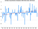
The other thing that's hard to ignore here wrt the TNH is the long-term upward trend & tendency for more +TNH winters since the mid-20th century.


Screenshot 2024-11-14 at 6.53.15 PM.png


When you compare the long-term SST warming trend (background climate change) to the +TNH correlation pattern, some of the reasons for this long-term upward trend in winter TNH (i.e. more frequent Hudson Bay vortex patterns) are much clearer.

The North Indian & Tropical Western Pacific are warming at a faster rate than the rest of the global tropics & this long-term warming pattern trend is significantly correlated with the +TNH pattern.

This means that the relative warming of the tropical Indo-Pacific (climate change/global warming related to a significant degree imo) is likely what is driving the increased frequency of +TNH in recent years to a large extent. In fact, +TNH winters have become ~2x more frequent since the mid-20th century.

If this is indeed the case, we may see more winters like this coming year (in general) as time wears on. That's really bad news for places like California however, who often become exceptionally dry during strong +TNH winters. I'm certainly afraid that the California "megadrought" might make a big comeback over the next year or two.


Sep-Oct-Nov +TNH SST correlation pattern

SON TNH SST Correlation pattern.gif


Sep-Oct-Nov long-term warming trend SST correlation pattern.
104.28.49.76.318.18.55.27.gif
 
As griteater mentioned on Bluesky, I agree that this winter will probably flip flop between -PNA & +TNH type Nina pattern flavors as subseasonal/MJO forcing orbits across the Indo-Pacific.

Indian Ocean MJO favors jet retraction & a western trough, while west pacific mjo activity adding some westerly momentum into the jet may dislodge the Aleutian ridge into Alaska, resulting in a -EPO/+TNH.

As we see the MJO enter the Indian Ocean into early to mid December, we probably will see the classic -PNA type pattern try to take hold & favor milder conditions for a majority of the month.

Late in the month into early January, that’s when things could get interesting as the MJO starts to enter the West Pacific yet again.

IMG_3724.png


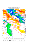
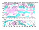
Phase 3 MJO DJF

IMG_3721.jpeg


Phase 7 MJO DJF
IMG_3723.jpeg
 
As griteater mentioned on Bluesky, I agree that this winter will probably flip flop between -PNA & +TNH type Nina pattern flavors as subseasonal/MJO forcing orbits across the Indo-Pacific.

Indian Ocean MJO favors jet retraction & a western trough, while west pacific mjo activity adding some westerly momentum into the jet may dislodge the Aleutian ridge into Alaska, resulting in a -EPO/+TNH.

As we see the MJO enter the Indian Ocean into early to mid December, we probably will see the classic -PNA type pattern try to take hold & favor milder conditions for a majority of the month.

Late in the month into early January, that’s when things could get interesting as the MJO starts to enter the West Pacific yet again.

View attachment 154275


Phase 3 MJO DJF

View attachment 154273


Phase 7 MJO DJF
View attachment 154274
Hopefully the mjo don't stall in the warmer phases and keep propagating and if it stalled, it would be in colder phases. I talked to Dr. Roundy and he believes mid end December should see more west Canada ridging and Alaska based on his regression model fwiw
 
GSO will record a low of 0 this year and see the ground covered with snow. Also have some above normal days in a see-saw back an forth winter. Thats my backyard NCSNOW winter outlook.
Bonus prediction is the turnips,coconut pies and pecan pies will taste just as good on Turkey day as they always have.
 
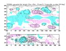
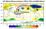
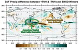
Here’s the SST, 500mb and precip anomaly differences between +TNH and -TNH winters during cool ENSO (cold neutral or La Niña) only.

You can see the wave train emanating from the tropical western pacific and maritime continent, where SSTs are warmer.

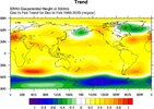
More importantly perhaps, the Maritime Continent & West Pacific is also where the SSTs are warming the fastest on the globe since the mid-20th century. The +TNH pattern shows up in the long-term pattern trends for winter. Imo, we are probably going to see more winters like the ones in the late 1980s (1988-89, 1989-90) mid 2010s (2012-13, 2013-14, & 2014-15) & this year as time goes on due to the long-term warming pattern trends in tropical SSTs

IMG_3710.jpeg

IMG_3714.jpeg

IMG_3715.jpeg


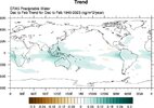
Long term 500mb and PWAT trends in ERA5 for Dec-Jan-Feb. Notice how it projects strongly onto the TNH pattern & NAO pattern to a degree


IMG_3708.jpeg
IMG_3711.jpeg
 

Attachments

  • IMG_3707.jpeg
    IMG_3707.jpeg
    129.9 KB · Views: 13
  • IMG_3709.jpeg
    IMG_3709.jpeg
    89.6 KB · Views: 13
Record strong polar vortex likely on the way to open up December. On brand for west qbo winter

I don’t think that’s the worst thing in the world though if we’re headed down the path towards a -EPO/+TNH winter. A strong stratospheric vortex could help anchor the Hudson Bay tropospheric vortex in place later in winter


IMG_3732.png
 
Back
Top