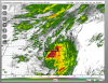
• Hello, please take a minute to check out our awesome content, contributed by the wonderful members of our community. We hope you'll add your own thoughts and opinions by making a free account!

Tropical TS Elsa

ya, I would imagine it doesn't happen often...I wonder if once it kind of goes through this phase if it helps kind of re-structure itself?
That’s actually exactly what is happening, the CCC pattern is tipping us off to a major restructuring process in Elsa with possible downshear center reformation

 
Im honestly not sure because now this is probably going to interact more with Jamaica and that too could throw yet another curve ball into things because the storm might get pinballed around the island
I will say the HWRF is west this run...almost brings landfall back to the big bend of FL...its TS lopsided mess, but like threads the needle btwn Jamaica and Cuba then crosses Cuba over West Central Cuba and heads like NNW into Eastern Gulf.
 
so does anyone have the maps, satellite, with the NHC tracks on them? know where to find them? like the ones that NHC main page used to have.

Just go here and select the storm. Select a Satellite Imagery at the top of the web page and then select an Image Resolution on the left side of the web page. The higher (finer) the resolution you choose, the larger the graphic. However, I think the satellite view is only updated about once every hour or so.


Example:

1625384647265.png

Hope this helps.
 
Last edited:
Well Elsa is starting to remind me of Isaias...huge convective mass but pressures not lowering.
Elsa let it (old LLC) go in lieu of a formation of a new LLC (via top down build down)...
Elsa must have hooked up with Thor last night caused she generated an extreme amount of lightning with that overnight convective burst.
Elsa is adjusting with such cold cloud tops (never bothered her anyway).

All puns aside ... i think Elsa threads the islands of Jamaica and Eastern Cuba today...we MIGHT see another situation where the islands may enhance channeled inflow to the reformed LLC later today/this afternoon
 
Just go here and select the storm. Select a Satellite Imagery at the top of the web page and then select an Image Resolution on the left side of the web page. The higher (finer) the resolution you choose, the larger the graphic. However, I think the satellite view is only updated about once every hour or so.


Example:

View attachment 86133

Hope this helps.
YES! Thank you
 
The 6z hwrf is a useless run. It had the center just south of eastern Cuba at this time getting ready to be shredded by the high terrain.
 
The 6z hwrf is a useless run. It had the center just south of eastern Cuba at this time getting ready to be shredded by the high terrain.
I really don’t think any of these models are going to give a useful picture until we know exactly where the center will cross Cuba. Right now it appears that it’s heading for a crossing near the most narrow part of the island. Even though the storm has slowed, a crossing there wouldn’t damage the storm’s structure too much and then it could be off to the races once in the Gulf.
 
Back
Top