Downeastnc
Member
Might be about to really take off with this new burst of convection
You can see her trying to form and clear out a eye like feature on the vis loop....some legit hot towers firing as well she is close to having her
Might be about to really take off with this new burst of convection
And also consistent with climatology
The ICON says no, and it will probably be right. It has never really changed course and climatology also favors it.This is why I think 2-5" is a good bet even back my way with closer to 4-8" back towards 77
Of the icon is right then adding it was first to show the turn into Texas for Beryl it will be more closely watched during the heart of the seasonThe ICON says no, and it will probably be right. It has never really changed course and climatology also favors it.
The ICON says no, and it will probably be right. It has never really changed course and climatology also favors it.
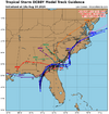
Even if the ICON is dead on about the track, as Brad P noted earlier today, it’s likely very much under modeling the extent westward of the rainfall shield. The interaction with the stalled front should make a much more expansive rain shield to the west of the trackThe ICON says no, and it will probably be right. It has never really changed course and climatology also favors it.
Personally if I had to make a call right now on a track, I would favor somewhere between the 12z Euro and the 18z ICON with a lean to the Euro simply because of how well it’s done on forecast tracks the last few years. Also I think the Icon is likely overdoing the strengthening off the SC coast which is part of the reason it goes furth north. Both models make a turn back to the NNW with the Euro doing it sooner with landfall just south Myrtle Beach and the ICON does it later leading to a landfall closer to Cape Lookout.What's with the ICON love all of a sudden? Euro/GFS/Ukie blend has preformed way better over the years. The NHC doesn't even mention it.
Sent from my iPhone using Tapatalk
What's with the ICON love all of a sudden? Euro/GFS/Ukie blend has preformed way better over the years. The NHC doesn't even mention it.
Sent from my iPhone using Tapatalk
Everyone is focused on their backyard. Your area is a lot different than mine or Shetleys area. You'll get big rain regardless. The Euro basically has nothing back this way either. A storm running the coast like this doesn't normally get the rainshield back this far. Hermine in 2016 didn't. Matthew in 2016 didn't. Seems as though there was one last year or the year before didn't. I don't pay much attention to that saying precip is always under modeled nw. It isn't with tropical systems. Climo says draw a line from Greenwood up through Union and Gastonia and anywhere west of that gets clouds and showers. Less than an inch for I85 from Atlanta to Gastonia. Brad P was talking about mainly nw NC into VA if the storm stalls and drifts nw while over NC it could interact with the front more up in that area.Even if the ICON is dead on about the track, as Brad P noted earlier today, it’s likely very much under modeling the extent westward of the rainfall shield. The interaction with the stalled front should make a much more expansive rain shield to the west of the track

Difference is there's a stalled front in this scenario that will enforce more precip back our way. If we get the Euro's track from 12z where it is situated closer to Lumberton, NC we will get more rain than the totals it spit out.Everyone is focused on their backyard. Your area is a lot different than mine or Shetleys area. You'll get big rain regardless. The Euro basically has nothing back this way either. A storm running the coast like this doesn't normally get the rainshield back this far. Hermine in 2016 didn't. Matthew in 2016 didn't. Seems as though there was one last year or the year before didn't. I don't pay much attention to that saying precip is always under modeled nw. It isn't with tropical systems. Climo says draw a line from Greenwood up through Union and Gastonia and anywhere west of that gets clouds and showers. Less than an inch for I85 from Atlanta to Gastonia. Brad P was talking about mainly nw NC into VA if the storm stalls and drifts nw while over NC it could interact with the front more up in that area.
It sure is. I have no idea where this run will lead, but if this is close to being right Savannah and Charleston are in trouble rainfall wise.18z is going to be weirder than 12ZGFS
We'll have to see when short range models come into range if they start picking up on more interaction with the front. The Euro isn't at the moment. As far as SE flow and upslope that would occur when the center is off the GA coast. My opinion we're too far away. Once the center gets to Lumberton , even though its closer the SE flow here is gone.Difference is there's a stalled front in this scenario that will enforce more precip back our way. If we get the Euro's track from 12z where it is situated closer to Lumberton, NC we will get more rain than the totals it spit out.
