-
Hello, please take a minute to check out our awesome content, contributed by the wonderful members of our community. We hope you'll add your own thoughts and opinions by making a free account!
You are using an out of date browser. It may not display this or other websites correctly.
You should upgrade or use an alternative browser.
You should upgrade or use an alternative browser.
Tropical Tropical Storm Beryl 2024
- Thread starter SD
- Start date
Belle Lechat
Member
- Joined
- Aug 29, 2021
- Messages
- 1,547
- Reaction score
- 1,224


Shaggy
Member
I was kinda scratching my head thinking the same thing.Is it me or does Beryl looks to be a NNW motion?
accu35
Member
I mean after looking at the radar earlier, it looks almost due north but probably notI was kinda scratching my head thinking the same thing.
That's what I was talking about.
Belle Lechat
Member
- Joined
- Aug 29, 2021
- Messages
- 1,547
- Reaction score
- 1,224
Recon data.
First, a line of format and a line of sample data, followed by what MMM and KKK stand for in the line.
hhmmss LLLLH NNNNNW PPPP GGGGG XXXX sTTT sddd wwwSSS MMM KKK ppp FF
142230 2612N 08752W 7010 03057 9282 +102 +102 141153 166 148 /// 00
MMM: Peak 10-second average wind speed occurring within the encoding interval, in kt. G-9/// indicates missing value.
KKK: Peak 10-second average surface wind speed occurring within the encoding interval from the Stepped Frequency Microwave Radiometer (SFMR), in kt. ///indicates missing value.
Now recent data.
215330 2318N 08905W 6964 03202 0109 +087 +066 101061 062 031 060 00
215400 2316N 08906W 6965 03200 0103 +091 +073 101059 061 012 021 00
215430 2314N 08908W 6955 03212 0099 +091 +076 106056 059 009 003 00
215500 2313N 08909W 6966 03197 0102 +088 +079 106056 057 003 002 00
215530 2311N 08911W 6957 03204 0097 +090 +085 107054 056 003 001 00
215600 2309N 08912W 6959 03201 0095 +090 +089 107053 054 000 000 00
215630 2307N 08914W 6955 03207 0087 +094 +093 112054 055 000 000 00
I presume they're at the eye, but
Belle Lechat
Member
- Joined
- Aug 29, 2021
- Messages
- 1,547
- Reaction score
- 1,224
Eye transfer from S to N where there is lightning?
Eye transfer from S to N where there is lightning?
There’s no eye anymore. Microwave imagery shows the inner core disrupted
Belle Lechat
Member
- Joined
- Aug 29, 2021
- Messages
- 1,547
- Reaction score
- 1,224
There’s no eye anymore. Microwave imagery shows the inner core disrupted
Anyone can answer, but how else to explain the difference of wind speeds aloft and at the surface (calm) but as a leaning eye?
15 minutes later
221100 2213N 08930W 6957 03173 0039 +110 +067 096057 058 047 038 00
221130 2211N 08930W 6964 03166 0050 +099 +088 089054 057 046 042 00
221200 2209N 08930W 6956 03171 0041 +101 +098 091050 057 000 000 01
221230 2207N 08930W 6963 03161 0033 +107 +088 092051 054 000 000 00
221300 2205N 08931W 6958 03165 0033 +104 +096 091052 054 005 004 00
221330 2203N 08931W 6956 03163 0023 +108 +102 092056 057 000 000 00
221400 2201N 08931W 6967 03151 0022 +109 +104 090056 057 000 000 00
221430 2159N 08931W 6957 03156 0023 +104 +111 082057 060 000 000 01
221500 2157N 08930W 6955 03155 0021 +100 +114 086055 057 000 000 01
221530 2155N 08930W 6960 03146 0016 +101 +118 087060 062 000 000 01
221600 2153N 08930W 6962 03140 0020 +097 +116 082059 062 000 000 01
221630 2151N 08930W 6950 03152 0015 +096 +116 084047 058 000 000 01
...
222230 2126N 08925W 6959 03111 9922 +145 +110 198003 006 039 021 00
222300 2124N 08924W 6962 03111 9930 +143 +106 263008 011 036 020 03
That’s the center.Anyone can answer, but how else to explain the difference of wind speeds aloft and at the surface (calm) but as a leaning eye?
15 minutes later
221100 2213N 08930W 6957 03173 0039 +110 +067 096057 058 047 038 00
221130 2211N 08930W 6964 03166 0050 +099 +088 089054 057 046 042 00
221200 2209N 08930W 6956 03171 0041 +101 +098 091050 057 000 000 01
221230 2207N 08930W 6963 03161 0033 +107 +088 092051 054 000 000 00
221300 2205N 08931W 6958 03165 0033 +104 +096 091052 054 005 004 00
221330 2203N 08931W 6956 03163 0023 +108 +102 092056 057 000 000 00
221400 2201N 08931W 6967 03151 0022 +109 +104 090056 057 000 000 00
221430 2159N 08931W 6957 03156 0023 +104 +111 082057 060 000 000 01
221500 2157N 08930W 6955 03155 0021 +100 +114 086055 057 000 000 01
221530 2155N 08930W 6960 03146 0016 +101 +118 087060 062 000 000 01
221600 2153N 08930W 6962 03140 0020 +097 +116 082059 062 000 000 01
221630 2151N 08930W 6950 03152 0015 +096 +116 084047 058 000 000 01
...
222230 2126N 08925W 6959 03111 9922 +145 +110 198003 006 039 021 00
222300 2124N 08924W 6962 03111 9930 +143 +106 263008 011 036 020 03
Recon shows the center offshore. 
Anyone can answer, but how else to explain the difference of wind speeds aloft and at the surface (calm) but as a leaning eye?
15 minutes later
221100 2213N 08930W 6957 03173 0039 +110 +067 096057 058 047 038 00
221130 2211N 08930W 6964 03166 0050 +099 +088 089054 057 046 042 00
221200 2209N 08930W 6956 03171 0041 +101 +098 091050 057 000 000 01
221230 2207N 08930W 6963 03161 0033 +107 +088 092051 054 000 000 00
221300 2205N 08931W 6958 03165 0033 +104 +096 091052 054 005 004 00
221330 2203N 08931W 6956 03163 0023 +108 +102 092056 057 000 000 00
221400 2201N 08931W 6967 03151 0022 +109 +104 090056 057 000 000 00
221430 2159N 08931W 6957 03156 0023 +104 +111 082057 060 000 000 01
221500 2157N 08930W 6955 03155 0021 +100 +114 086055 057 000 000 01
221530 2155N 08930W 6960 03146 0016 +101 +118 087060 062 000 000 01
221600 2153N 08930W 6962 03140 0020 +097 +116 082059 062 000 000 01
221630 2151N 08930W 6950 03152 0015 +096 +116 084047 058 000 000 01
...
222230 2126N 08925W 6959 03111 9922 +145 +110 198003 006 039 021 00
222300 2124N 08924W 6962 03111 9930 +143 +106 263008 011 036 020 03
Southwesterly shear tilting the system.
Belle Lechat
Member
- Joined
- Aug 29, 2021
- Messages
- 1,547
- Reaction score
- 1,224
So an eyewall isn't needed to achieve the calm at the center.That’s the center.
222330 2122N 08924W 6955 03125 9949 +130 +107 259007 011 000 000 03
Belle Lechat
Member
- Joined
- Aug 29, 2021
- Messages
- 1,547
- Reaction score
- 1,224
Southwesterly shear tilting the system.
") Yes, that's what I was trying to say by leaning.
Yes, that's what I was trying to say by leaning.Belle Lechat
Member
- Joined
- Aug 29, 2021
- Messages
- 1,547
- Reaction score
- 1,224
The lowest extrapolated surface pressure they read there.
222230 2126N 08925W 6959 03111 9922 +145 +110 198003 006 039 021 00
222230 2126N 08925W 6959 03111 9922 +145 +110 198003 006 039 021 00
Belle Lechat
Member
- Joined
- Aug 29, 2021
- Messages
- 1,547
- Reaction score
- 1,224
Belle Lechat
Member
- Joined
- Aug 29, 2021
- Messages
- 1,547
- Reaction score
- 1,224
A second plane is en route.

Belle Lechat
Member
- Joined
- Aug 29, 2021
- Messages
- 1,547
- Reaction score
- 1,224
Most recent low extrapolated surface pressure, 990.9 mb.
232730 2133N 08931W 6440 03766 9909 +122 +038 190017 020 /// /// 03
6:27 CDT
232730 2133N 08931W 6440 03766 9909 +122 +038 190017 020 /// /// 03
6:27 CDT
Belle Lechat
Member
- Joined
- Aug 29, 2021
- Messages
- 1,547
- Reaction score
- 1,224
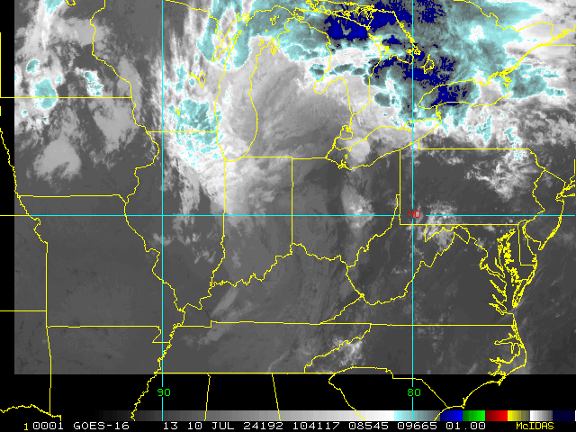
Posting on this page to primarily show how close Beryl's clouds are to Louisiana.
Belle Lechat
Member
- Joined
- Aug 29, 2021
- Messages
- 1,547
- Reaction score
- 1,224

Belle Lechat
Member
- Joined
- Aug 29, 2021
- Messages
- 1,547
- Reaction score
- 1,224
...CENTER OF BERYL ABOUT TO EMERGE OVER THE GULF OF MEXICO...
7:00 PM CDT Fri Jul 5
Location: 21.3°N 89.7°W
Moving: WNW at 15 mph
Min pressure: 994 mb
Max sustained: 65 mph

7:00 PM CDT Fri Jul 5
Location: 21.3°N 89.7°W
Moving: WNW at 15 mph
Min pressure: 994 mb
Max sustained: 65 mph
18z Euro 
Belle Lechat
Member
- Joined
- Aug 29, 2021
- Messages
- 1,547
- Reaction score
- 1,224
Show more
Hence, I doubt we’re done with the northward adjustments on the models here. There will probably some additional downshear "tugging" of #Beryl's low-level vortex prior to its inner core becoming re-established that the models will have a hard time (continuing to) forecast.
Brent
Member
Terrible storm for the Euro for sure. Brownsville to Galveston is about 400 miles...
11pm EST update. Hurricane watches extended eastward 
Brent
Member
Not looking so hot tonight for once
Belle Lechat
Member
- Joined
- Aug 29, 2021
- Messages
- 1,547
- Reaction score
- 1,224
Not looking so hot tonight for once
The last time recon had a extrapolated surface pressure reading under 1000 mb was at 10:32 PM CDT.
Belle Lechat
Member
- Joined
- Aug 29, 2021
- Messages
- 1,547
- Reaction score
- 1,224
The entire Texas coast is in the cone and Mexico is out.

Belle Lechat
Member
- Joined
- Aug 29, 2021
- Messages
- 1,547
- Reaction score
- 1,224
The 4:00 AM CDT Advisory had 1001 mb. Recon just reported 995.
103600 2228N 09135W 6961 03142 9953 +153 +094 194011 013 014 013 00
At 5:23 AM CDT the recent highest Peak 10-second average surface wind speed was 58 kts, 67 mph.
102300 2311N 09105W 6948 03181 0032 +105 +120 135051 059 058 054 01
If you think Beryl looks bad now, it recently looked awesomely bad; it's just starting to look significantly better. It has the clear look of gaining strength.
Last edited:
Belle Lechat
Member
- Joined
- Aug 29, 2021
- Messages
- 1,547
- Reaction score
- 1,224


Belle Lechat
Member
- Joined
- Aug 29, 2021
- Messages
- 1,547
- Reaction score
- 1,224
I don't know how many hours Beryl went without a spot of red on this map.
Henry2326
Member
Tropical Storm Beryl Discussion Number 31
NWS National Hurricane Center Miami FL AL022024
400 AM CDT Sat Jul 06 2024
Beryl's structure this morning is a shadow of its former self in the
Caribbean, with the low-level center partially exposed and displaced
south of the best mid-level rotation and deep convection. The final
couple of Air Force Hurricane Hunter fixes indicated the pressure
was rising, though the aircraft did also observe 850-mb flight level
winds of 65 kt, which still supports maintaining an initial
intensity of 50 kt. This value is between the Dvorak intensity
estimates provided by TAFB and SAB. Beryl's wind radii were adjusted
some from to a combination of aircraft, scatterometer, and synthetic
aperture radar wind data.
Beryl is currently estimated to be moving west-northwest at
300/10-kt. Soon, the tropical storm is expected to turn more
northwestward and gradually slow down as the steering currents
evolve due to both a weakness developing in the subtropical ridge to
the north, in addition to an upper-level low positioned west of
Beryl also imparting more poleward steering. After the significant
rightward shifts in the track guidance over the past day or so, the
latest cycle has come into better agreement very near the previous
NHC forecast track. In fact, the latest forecast track is very close
to the prior forecast, roughly between the latest GFS and ECMWF
forecasts. This track also splits the difference between the
reliable TVCN and HCCA consensus aids. However, it should be noted
that there still remains a fair amount of across-track spread in the
latest ECMWF ensemble guidance at the time Beryl is forecast to make
landfall in Texas on Monday.
The poor structure of the tropical storm this morning does not favor
much intensification in the short-term, and I suspect it will take
another day or so for convection to reorganize around the inner core
of Beryl. This process could also be slowed by a decent amount of
dry air in the southern Gulf of Mexico being imported into Beryl's
circulation by about 20 kt of southerly wind shear. However, this
wind shear decreases to under 10 kt per SHIPS guidance after 24
hours as Beryl moves into very warm 29-30 C sea-surface
temperatures. The upper-level low currently inducing the southerly
shear will also become positioned farther southwest of Beryl, in a
quadrant more favorable for TC intensification. Thus, strengthening
is expected to begin on Sunday with the rate of intensification
likely to increase in the final 24 hours before landfall, in
agreement with the most favorable conditions being prescribed by the
GFS and ECMWF models. The intensity forecast remains on the high
side of the guidance envelope, but is also similar to the prior
forecast and shows Beryl becoming a hurricane before reaching the
Texas coast on Monday.
It is important to note that the average NHC track error at 60 hours
is about 80 miles and the average intensity error is close to one
category. Users are reminded to consider these uncertainties when
using the forecast information.
Key Messages:
1. There is an increasing risk of damaging hurricane-force winds and
life-threatening storm surge in portions of northeastern Mexico and
the Texas Coast late Sunday into Monday, where Hurricane and Storm
Surge Watches are in effect. Additional watches and warnings may be
required later today. Interests in these areas should follow any
advice given by local officials.
2. Flash and urban flooding, some of which may be locally
considerable in nature, is likely across portions of the Texas Gulf
Coast and eastern Texas beginning late Sunday through midweek.
3. Rip currents will cause life-threatening beach conditions through
the weekend across much of the Gulf Coast. Beachgoers should heed
warning flags and the advice of lifeguards and local officials
before venturing into the water.
FORECAST POSITIONS AND MAX WINDS
INIT 06/0900Z 22.2N 91.3W 50 KT 60 MPH
12H 06/1800Z 23.3N 92.7W 50 KT 60 MPH
24H 07/0600Z 24.4N 94.3W 55 KT 65 MPH
36H 07/1800Z 25.6N 95.5W 60 KT 70 MPH
48H 08/0600Z 27.0N 96.4W 70 KT 80 MPH
60H 08/1800Z 28.5N 96.7W 80 KT 90 MPH...ON THE COAST
72H 09/0600Z 30.3N 96.5W 35 KT 40 MPH...INLAND
96H 10/0600Z 32.9N 94.0W 25 KT 30 MPH...POST-TROP/INLAND
120H 11/0600Z 35.5N 90.1W 20 KT 25 MPH...POST-TROP/INLAND
Belle Lechat
Member
- Joined
- Aug 29, 2021
- Messages
- 1,547
- Reaction score
- 1,224
113930 2228N 09142W 8424 01490 9983 +199 +148 237007 008 020 003 00
6:39 CDT 998.3 mb
6:39 CDT 998.3 mb
Belle Lechat
Member
- Joined
- Aug 29, 2021
- Messages
- 1,547
- Reaction score
- 1,224
7:00 AM CDT Sat Jul 6
Location: 22.7°N 91.9°W
Moving: WNW at 12 mph
Min pressure: 999 mb
Max sustained: 60 mph

Location: 22.7°N 91.9°W
Moving: WNW at 12 mph
Min pressure: 999 mb
Max sustained: 60 mph
Belle Lechat
Member
- Joined
- Aug 29, 2021
- Messages
- 1,547
- Reaction score
- 1,224
114230 2217N 09144W 6962 03158 9962 +164 +057 249027 027 /// /// 03
6:14 CDT
6:14 CDT
Last edited: