Shaggy
Member


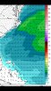
lol HRRR hates ML cape this afternoonView attachment 85033
Good thing the short range models have been absolute garbage so far this summer. Lol.
In a perfect world we catch some rain from the disturbance today and tomorrow but I'm not sold we can get that lucky. The disturbance today might be too late and we start getting a lot of CINH in place and the outflow does like it did Monday where the outflow generated convection becomes less and less as the evening progresses. I really like the disturbance tomorrow but I worry we end up with too might subsidence on the back of todays disturbance and possibly too much debris clouds. We will see
I wouldn’t be too worried although with our luck we will se how find a way in between cells .. but regardless the storms look much more widespread then past days and it even goes into the night tonight .. and multiple rounds showing up tomorrow ... i dont know i Think many continue the beneficial rain parade today and tomorrowIn a perfect world we catch some rain from the disturbance today and tomorrow but I'm not sold we can get that lucky. The disturbance today might be too late and we start getting a lot of CINH in place and the outflow does like it did Monday where the outflow generated convection becomes less and less as the evening progresses. I really like the disturbance tomorrow but I worry we end up with too much subsidence on the back of todays disturbance and possibly too much debris cloudiness. We will see
Still whiffing in the rain department this week. Going to end up missing the whole thing


This is exactly what I was talking about a couple weeks ago when saying you really can’t look at precip output when looking at these models this time of the year. Much of precip right now comes from convection firing up in the afternoon and as you said above, even the short range models are having a difficult time with total coverage and amounts. This is where we just got to look at the overall setup. Right now I feel good about the opportunity for most of us in the Carolinas to get some widespread soaking rain the next couple days. Hopefully the Triad folks can get in on the action… they’ve been fairly unlucky compared to other area the last few daysPrime example of just how bad modeling has been. Basically every model showed your area getting a really good soaking.
Hrrr has got some 70dbzs around this evening
Truly wonder if it whiffs or we can get the western part of the cluster to get going and merge with the stuff more towards the east, on the HRRR it weakens, earlier initiation helps tremendously im guessing with this setupHrrr has got some 70dbzs around this evening


It's gotta be mixing too muchTruly wonder if it whiffs or we can get the western part of the cluster to get going and merge with the stuff more towards the east, on the HRRR it weakens, earlier initiation helps tremendously im guessing with this setup View attachment 85037View attachment 85038
.png")
Agreed. It has my DP at 66 and it hasn’t been below 70 for me since Saturday. Right now it’s at 71 and I don’t see it mixing out much with a SW windIt's gotta be mixing too much
View attachment 85039
I'm at 81/75 if we mix out of this I give upAgreed. It has my DP at 66 and it hasn’t been below 70 for me since Saturday. Right now it’s at 71 and I don’t see it mixing out much with a SW wind


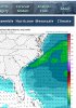
83/73 over 2000 CAPE how do we blow thislatest SPC mesoanalysis showing 3000+ SBcape for most areas east of the mountains, far more then the HRRR
No kidding that stuff in VA is starting to put itself together
Should be plenty of CTG lightning todayNo kidding that stuff in VA is starting to put itself together
-------- @SD were fighting a fine line here


.png")