Webberweather53
Meteorologist
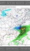
Verbatim, this wave over TX would probably be capable of producing wintry weather around New Years if this Euro run went out more than 10 days. Obviously, it's futile to speculate so far out but the point that's trying to be made here is that this is very far from being a blowtorch.
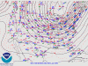
Certainly would wager that this week's cut-off ULL may be far from the last one we see this winter esp if the STJ continues to remain active & we have blocking over eastern Canada. Also notice, the main lobe of tropospheric polar vortex is still lurking around in our backyard just north of Greenland.
View attachment 28655
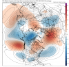
This afternoon's Euro run really isn't that much different from the 0z EPS mean valid for roughly the same time. Sure a few details are different but it's not like this run is way out in left field.


.png")
.png")