They are tricky to predict but they always rear their ugly head at some point .. could end up being the wildcard that saves us from too much warmth and even be what brings us the goodsYeah I’m 90% sure the one that spins for a day or two and kicks in the first 100 hours of the 12z GFS was once there for 2 weeks straight earlier last week
-
Hello, please take a minute to check out our awesome content, contributed by the wonderful members of our community. We hope you'll add your own thoughts and opinions by making a free account!
You are using an out of date browser. It may not display this or other websites correctly.
You should upgrade or use an alternative browser.
You should upgrade or use an alternative browser.
Pattern The Great December Dump
- Thread starter Rain Cold
- Start date
NBAcentel
Member
Yeah I’m 90% sure the one that spins for a day or two and kicks in the first 100 hours of the 12z GFS was once there for 2 weeks straight earlier last week
Yeah probably that run that gave Texas the Mega ice storm, or the SE a mega miller B, lol
NBAcentel
Member
+PNA really saved that run from being a dumpster fire, but no -EPO, no -NAO or -AO 
+PNA really saved that run from being a dumpster fire, but no -EPO, no -NAO or -AO View attachment 28929
I'll take anything to get us some relief in the form of a couple of colder than normal days after the upcoming late Dec torch. But will it verify?
Some factors outweigh others and sometimes u don’t need them all to be in the favorable position to get a winter storm .. pattern is volatile rn+PNA really saved that run from being a dumpster fire, but no -EPO, no -NAO or -AO View attachment 28929
tennessee storm
Member
Maybe it increase future runs ... models do under estimate cape frequentlyThis was close to something bad, just little amounts of cape View attachment 28928
cd2play
Member
Heck, why not?! Winter is becoming our new primary severe weather season.Maybe it increase future runs ... models do under estimate cape frequently
Jessy89
Member

At least we have something in fantasy range
Sent from my iPhone using Tapatalk
cd2play
Member

At least we have something in fantasy range
Sent from my iPhone using Tapatalk
 Next
NextATLwxfan
Member
Finally...we are headed for glory!

Sent from my iPhone using Tapatalk

Sent from my iPhone using Tapatalk
Sorry but this is just pathetic that Denver will go snowless in December for the first time in 113 years. At least most of the nation is with us when it’s usually just the s/e. 
accu35
Member
Interesting time period

BHS1975
Member
Interesting time period
4 please. Thank you.
Sent from my iPhone using Tapatalk
Ilovesnow28
Member
12 pleaseInteresting time period
Stratospheric warming over out part of the world definitely doesn't mean it's going to be warm at the surface.
In this case it does....
Sent from my iPhone using Tapatalk
Cad Wedge NC
Member
Yeah, we are really good at finding a warm pattern.In this case it does....
Sent from my iPhone using Tapatalk
Webberweather53
Meteorologist
No, it doesn’t because there is no really significant warming in the stratosphere in the NH that would force a warm pattern. It actually works the other way around, a cold stratosphere entices the tropopause heights to rise >> warmer troposphere & vis versa with a warm stratosphere. I’m not sure why this is an argument because it shouldn’t be.In this case it does....
Sent from my iPhone using Tapatalk
NBAcentel
Member
No, it doesn’t because there is no really significant warming in the stratosphere in the NH that would force a warm pattern. It actually works the other way around, a cold stratosphere entices the tropopause heights to rise >> warmer troposphere & vis versa with a warm stratosphere. I’m not sure why this is an argument because it shouldn’t be.
I know this I more related to “GW” but is this why stratospheric temps have cooled while tropospheric temps have rose on average ?
D
Deleted member 609
Guest
we dancing again boys?
Webberweather53
Meteorologist
Tropospheric temperatures have risen due to greenhouse gases selectively absorbing and re-emitting outgoing IR towards the surface. The consequent cooling in the stratosphere is a signature of tropospheric greenhouse gases blocking outgoing long wave IR (heat) from reaching the stratosphere (thereby cooling it) (this is also more formally known as the “blocking effect”), there’s also a significant contribution from anthropogenic CFCs and HCFCs that destroy ozone & hence cool the stratosphereI know this I more related to “GW” but is this why stratospheric temps have cooled while tropospheric temps have rose on average ?
No, it doesn’t because there is no really significant warming in the stratosphere in the NH that would force a warm pattern. It actually works the other way around, a cold stratosphere entices the tropopause heights to rise >> warmer troposphere & vis versa with a warm stratosphere. I’m not sure why this is an argument because it shouldn’t be.
I’m not arguing the facts. I find it mere coincidental every time we have warmer tropopause heights the cold air moves over to the cooler side.
Sent from my iPhone using Tapatalk
Webberweather53
Meteorologist
For one thing, there’s a massive difference in impacts from warm tropopause heights and a warm low-middle stratosphere and these temperature anomalies are often a reflection tropospheric wave activity rather than a forcing in the traditional senseI’m not arguing the facts. I find it mere coincidental every time we have warmer tropopause heights the cold air moves over to the cooler side.
Sent from my iPhone using Tapatalk
thanksgivingbrown
Member
I know it's the crazy morning run but gfs was close next week I'll be in Gatlinburg so book it! Its guna happen!
thanksgivingbrown
Member
NBAcentel
Member
I missed this feeling of soup in the air
ForsythSnow
Moderator
The euro ended so close to something

NoSnowATL
Member
The euro ended so close to something
We need that low farther south then I’ll be interested .
Sent from my iPhone using Tapatalk
thanksgivingbrown
Member
Tornado watch out and this place is as quiet as a church mouse
NBAcentel
Member
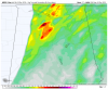
some damaging wind gusts/QLCS spin up tornadoes are possible, altho this is not impressive, and forcing is linear which mutes the tornado threat quite a bit, thermodynamics/low level instability and llvl lapse rates ain’t impressive, but SRH is definitely up there so like I said QLCS spinups is definitely possible
Honestly the euro verbatim would have probably been fun for a lot of NC as that low was pretty far south and cold filtering inThe euro ended so close to something
pcbjr
Member
It is cold someplace. In fact, it's plenty of cold in many places. Just not here in this neck of the woods. If fortunes were reversed, a lot of other folks would be bemoaning the warmth. It's just a matter of wind and pattern. Nothing more and nothing less.
Sure is quiet in here considering there is a Tornado Warning for Starkville, MS.
Dec 2019 ended up 6.6 AN temps for Chattanooga.. 9 years running now with AN Decembers. 2010 was the last time below normal. Truly weird actually.