VegasEagle
Member
Hmmm.... That is interesting for sure. What are the odds tonight of this happening?Storm5 link said:00z cmc
Sent from my SM-G900V using Tapatalk
Hmmm.... That is interesting for sure. What are the odds tonight of this happening?Storm5 link said:00z cmc
Sent from my SM-G900V using Tapatalk
SD link said:12z NAM has a change to freezing rain for much of Tn and north Al, even a change to snow possibly in Tn


So we have the CMC and Euro faster with the cold and a little longer w the precip vs GFS...Let's see what Euro 12z says...Storm5 link said:cmc is more bullish . gfs is the slowest with the cold push out of the big three
Sent from my SM-G900V using Tapatalk
accu35 link said:18 gfs looks better for this period, someone post image please


Brick Tamland link said:Euro looks like it could be .50 here of precip and mostly frozen to me.
Supershow link said:[quote author=accu35 link=topic=54.msg2223#msg2223 date=1481838806]
18 gfs looks better for this period, someone post image please
accu35 link said:[quote author=Supershow link=topic=54.msg2227#msg2227 date=1481841457]
[quote author=accu35 link=topic=54.msg2223#msg2223 date=1481838806]
18 gfs looks better for this period, someone post image please

15 for the win!tellicowx link said:
18z GEFS members...looks like an almost 50/50 split for this Sunday across middle TN, N. AL
Sent from my SM-S820L using Tapatalk


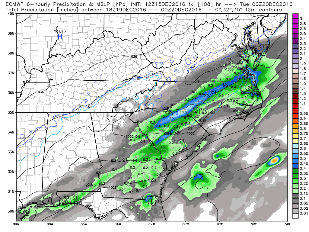
Webberweather53 link said:ECMWF is still very close to being a huge deal in central NC. I definitely don't feel comfortable at all seeing a wide swath of an inch to an inch and a half of precip with temperatures hovering around 31-34F. It's definitely trended a tad warmer the past day or so, but it's still way too close to call. Should be interesting to see how it handles this first CAD event on Fri Night into Sat
Supershow link said:[quote author=Webberweather53 link=topic=54.msg2281#msg2281 date=1481896639]
ECMWF is still very close to being a huge deal in central NC. I definitely don't feel comfortable at all seeing a wide swath of an inch to an inch and a half of precip with temperatures hovering around 31-34F. It's definitely trended a tad warmer the past day or so, but it's still way too close to call. Should be interesting to see how it handles this first CAD event on Fri Night into Sat
Brick Tamland link said:Even if just half of that is frozen around here it would be trouble.
Webberweather53 link said:[quote author=Brick Tamland link=topic=54.msg2300#msg2300 date=1481901711]
Even if just half of that is frozen around here it would be trouble.
NCSNOW link said:This is really going to get the attn it deserves if the euro stays course at 12z today. Love stalled fronts on our coast in the dead of winter with waves runining up them. Like that HP Monday heading to Tuesday, beleive it was 1038 on euro 500mb map I glanced at on plymouth or unisys. Have to go back and check.
Raleigh:
The surface cold front is expected to stall
near the coast early to mid next week as the front becomes parallel
with the mid/upper level flow. Multiples waves of low pressure are
expected to track along the front early next week, before a northern
stream s/w finally push the front further to the east and south by
Tuesday afternoon. Until then expect periods of mainly cold rain,
best chances east/southeast. If moisture spreads back into the
northwest Piedmont we could see a brief period of wintry weather
with cold high pressure extending into the area from the north and
northwest. However, with low confidence with regard to the timing
and strength of such waves will keep everything liquid for now.
Temps are expected to be below normal early next week, with highs on
Monday in the 30s to around 40, a


NCSNOW link said:Pretty confident in the 1044 HP being parked where it is come Mon night/Tueesday and a front stalled on the coast. Its a matter of the impulses riding up it and how much lift they have with them thats the unanswered question that has to be answered over the wekend. I'm throwing my chips on this one now if Euro holds serve at 12z today. Inside 120 hrs it still the king for a reason.
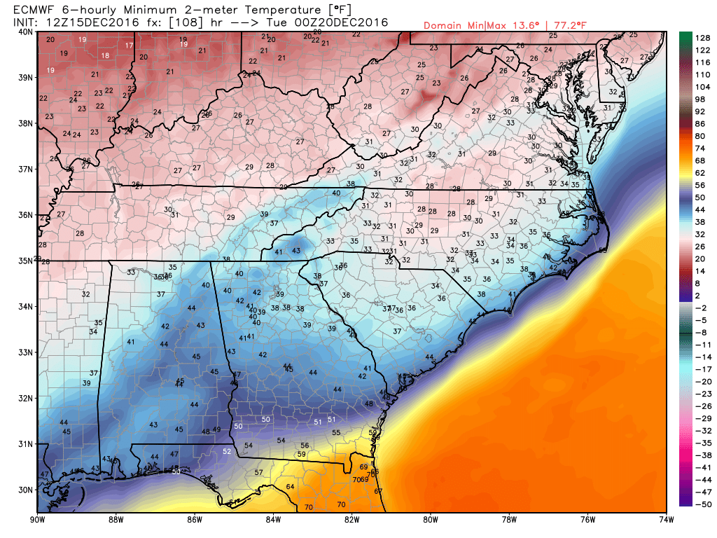
SD link said:Looks like we are too warm aloft to support anything but rain/freezing rain Monday/Tuesday. Thought we might have a chance to end as IP/SN but it doesn't look likely


