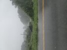
Some big time winds near Temple, Villa Rica heading towards downtown
-
Hello, please take a minute to check out our awesome content, contributed by the wonderful members of our community. We hope you'll add your own thoughts and opinions by making a free account!
You are using an out of date browser. It may not display this or other websites correctly.
You should upgrade or use an alternative browser.
You should upgrade or use an alternative browser.
Severe Severe Weather Threat 8/7/2023
- Thread starter Metwannabe
- Start date
Brick Tamland
Member
JUST IN:
Tornado Warning
National Weather Service Greenville-Spartanburg SC
508 PM EDT Mon Aug 7 2023
The National Weather Service in Greenville-Spartanburg has issued a
* Tornado Warning for...
Cabarrus County in the Piedmont of North Carolina...
Northern Mecklenburg County in the Piedmont of North Carolina...
* Until 600 PM EDT.
* At 508 PM EDT, a severe thunderstorm capable of producing a tornado
was located near Huntersville, moving east at 45 mph.
HAZARD...Tornado.
SOURCE...Radar indicated rotation.
IMPACT...Flying debris will be dangerous to those caught without
shelter. Mobile homes will be damaged or destroyed.
Damage to roofs, windows, and vehicles will occur. Tree
damage is likely.
* This dangerous storm will be near...
Huntersville, Northwest Charlotte and Davidson around 510 PM EDT.
Northeast Charlotte and University City around 520 PM EDT.
Downtown Concord, West Concord, Harrisburg, Charlotte Motor
Speedway and Reedy Creek Park around 530 PM EDT.
Midland and Mt Pleasant around 540 PM EDT.
Other locations impacted by this dangerous thunderstorm include
Croft.
PRECAUTIONARY/PREPAREDNESS ACTIONS...
TAKE COVER NOW! Move to a basement or an interior room on the lowest
floor of a sturdy building. Avoid windows. If you are outdoors, in a
mobile home, or in a vehicle, move to the closest substantial shelter
and protect yourself from flying debris.
Please report damaging winds, hail, or flooding to the National
Weather Service by calling toll free, 1, 800, 2 6 7, 8 1 0 1, or by
posting on our Facebook page, or Tweet it using hashtag nwsgsp. Your
message should describe the event and the specific location where it
occurred.
vsublazer
Member
The wind is a whipping and the clouds are moving fast.
CannedHeat
Member
Wild storm in Huntersville.
Atlanta is getting smoked right now
Brick Tamland
Member
Tornado Warning for...
Montgomery County in central North Carolina...
Stanly County in central North Carolina...
* Until 630 PM EDT.
* At 543 PM EDT, a severe thunderstorm capable of producing a tornado
was located over Mt Pleasant, or 11 miles east of Downtown Concord,
moving east at 50 mph.
HAZARD...Tornado.
SOURCE...Radar indicated rotation.
IMPACT...Flying debris will be dangerous to those caught without
shelter. Mobile homes will be damaged or destroyed.
Damage to roofs, windows, and vehicles will occur. Tree
damage is likely.
* This dangerous storm will be near...
Plyler around 550 PM EDT.
Albemarle and Badin Lake around 600 PM EDT.
Troy around 620 PM EDT.
Biscoe around 625 PM EDT.
Other locations impacted by this tornadic thunderstorm include
Uwharrie Haven, Steeds, Eldorado, Badin and Fish Tales Marina.

71mph wind gust measured at Peachtree Dekalb airport
Brick Tamland
Member
Seems like it's calming down in NC just in time before it moves into the Triangle.
Cary_Snow95
Member
Tornado warning in Siler City
JHS
Member
We had winds of around 50 mph here and a couple of limbs down. Thankful it was not any worse.
I trust their instrumentation more then any other airport in our region.71mph wind gust measured at Peachtree Dekalb airport
Brick Tamland
Member
Tornado Warning for...
East central Randolph County in central North Carolina...
Northwestern Lee County in central North Carolina...
Southwestern Chatham County in central North Carolina...
* Until 700 PM EDT.
* At 627 PM EDT, a severe thunderstorm capable of producing a tornado
was located 8 miles west of Siler City, moving east at 50 mph.
HAZARD...Tornado.
SOURCE...Radar indicated rotation.
IMPACT...Flying debris will be dangerous to those caught without
shelter. Mobile homes will be damaged or destroyed.
Damage to roofs, windows, and vehicles will occur. Tree
damage is likely.
* This dangerous storm will be near...
Siler City around 635 PM EDT.
Goldston around 645 PM EDT.
Pittsboro around 655 PM EDT.
Other locations impacted by this tornadic thunderstorm include
Cumnock, Coleridge, Hasty, Bynum and Ramseur.
I don’t know how much we’ll see N&W of 85 in this area. Seems like it’s focused on areas that saw a lot more sun today


