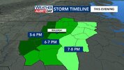
Where was the warning?Tornado warning popped already.
Sent from my iPhone using Tapatalk
-
Hello, please take a minute to check out our awesome content, contributed by the wonderful members of our community. We hope you'll add your own thoughts and opinions by making a free account!
You are using an out of date browser. It may not display this or other websites correctly.
You should upgrade or use an alternative browser.
You should upgrade or use an alternative browser.
Severe Severe Weather Threat 8/7/2023
- Thread starter RBR71
- Start date
Steven_1974
Member
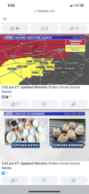
Looks like the only tornado warning I see right now is in Kentucky.Where was the warning?
Cary_Snow95
Member
Am I missing something. Under a heat advisory but it’s 131pm and it’s 79.5 degrees haha.
vsublazer
Member
For the GA folks.
BHS1975
Member
Am I missing something. Under a heat advisory but it’s 131pm and it’s 79.5 degrees haha.

Sent from my iPhone using Tapatalk
That stubborn cloud deck in central part of state setting up some decent temperature differentials, could add a little fuel to the fireAm I missing something. Under a heat advisory but it’s 131pm and it’s 79.5 degrees haha.
Cary_Snow95
Member
My location in Cary still 82.9 but am climbing a bit now that sun is leaking in
Sent from my iPhone using Tapatalk
Avalanche
Member
Banking up against the Apps right now. Wonder if it will survive them in their eastward progression
Nerman
Member
Schools are letting out here a few minutes early I guess in an abundance of caution. It's hot, humid and the wind is already blowing. Definitely feels ominous.
The HRRR is truly all over the place lol. It seems to be struggling mightily today
68mph wind gust reported at the Chattanooga airport
vsublazer
Member
Pop up showers are starting to fire up in Metro ATL ahead of the line. Under one now at my house.
Edit: still raining and now sunny. So far .15 in the bucket. Where the husband is in Acworth nothing but sunny conditions.
Edit: still raining and now sunny. So far .15 in the bucket. Where the husband is in Acworth nothing but sunny conditions.
Last edited:
NEAR TERM /TONIGHT/...
As of 200 PM Monday...
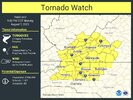
- Tornado Watch in effect through 9 PM this evening for the Triad
region. Additional convective watches may be needed farther east
later today.
The stage still appears to be set for a notable severe weather
episode across central NC later this afternoon as the squall line
currently moving across eastern TN spreads eastward and eventually
moves across our area between 21Z and 02Z this evening. All of this
activity associated with a short wave trough moving across the Ohio
Valley and a mid-level and upper-level jet streak lifting E and NE
around the base and eastern side of the trough.
The main challenge so far today has been the pesky low clouds over
the Piedmont that have been slow to erode. These clouds have held
sfc temps back so far, but now that they are finally eroding, we`re
seeing temps climbing through the 80s across the Piedmont. Areas
east of I-95 have had no problem climbing into the 90s with HI
values currently approaching 100 in many spots, yet still a couple
degrees shy of heat index criteria.
The challenge for the rest of this afternoon will be determining to
what extent the aforementioned low clouds may inhibit CAPE as the
storms cross the mountains and head toward our CWA. Despite the
slightly cooler temps than original expected, the overall forcing
for ascent associated with the potent short wave trough, coupled
with the increasing bulk shear which is expected to increase to 35-
40kt over our area by the time the storm arrive, should be enough to
overcome any local minimums in instability to result in scattered to
numerous damaging thunderstorms with the primary hazard being
damaging wind gusts, but isold tornadoes and hail can`t be ruled out
either. A tornado watch is in effect through 9 PM this evening for
the Triad region. Additional convective watches may be needed
farther east later today.
Storms are expected to exit our CWA to our east before midnight with
some patches of stratus and/or fog developing before sunrise, but
this will likely depend on where the heaviest rain falls later
today. Lows tonight from the upper 60s NW to mid 70s SE.
KRDU seems to still be pretty bullish despite the cloud cover that has inhibited temperatures. Now we'll see if the storms can hold together or redevelop as they cross the mountains.
I understand the breakdown, but shouldn't anyone over the age of 18 or so understand and know the differences? I see people all the time saying "Ooo I did not know that" and I wonder how they got that far in life.....Very good explanation for newbies! Seriously best I’ve ever seen! Some people are visual learners! View attachment 136087
Anyways, warm, humid, and SW wind seems to be blowing a bit. Ready for a disappointment here in JoCo.
Same, which might help to stabilize the atmosphere some.Pop up showers are starting to fire up in Metro ATL ahead of the line. Under one now at my house.
vsublazer
Member
Got down to 77. Now have gotten back up to 81 with a dew point of 81. Time will tell with this system.Same, which might help to stabilize the atmosphere some.
I haven't had much cloud cover here. It's been mostly sunny all day and humid.
Radar looking busy back west. When thunder roars, stay indoors.
Atlanta at 92/76. Juicy.
Athens sitting at 93/75
Up to 95/74 here. Dewpoint has crept back up after mixing out to 70 earlier.
Bannerdude
Member
BHS1975
Member
Much higher SBCAPE today.

Sent from my iPhone using Tapatalk

Sent from my iPhone using Tapatalk
Full Sun and blue skies. You wouldn’t even know anything was coming..it’s got that vibe to it doesn’t it
To the east is the heat advisory, no severe watch as of yet. I'm sure the Triangle will be added later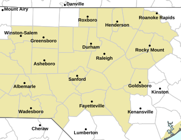
East and south of the Triangle, there is now a Severe Thunderstorm Watch. To the west, there is a Tornado Watch. The Triangle must have its storm shields up at maximum power. I don't recall seeing anything like this before.
That’s a Severe Thunderstorm Watch south and east of the Triangle. That’s the Heat Advisory. The purple in the bottom left over Cabarrus and Union counties is the Severe Thunderstorm Watch. I’m sure the area east of that will be under one fairly shortly
East and south of the Triangle, there is now a Severe Thunderstorm Watch. To the west, there is a Tornado Watch. The Triangle must have its storm shields up at maximum power. I don't recall seeing anything like this before.
Oops, it's time for me to get the eyes checked for color blindness! You are right about watches for the Triangle east probably being added later.To the east is the heat advisory, no severe watch as of yet. I'm sure the Triangle will be added later
Stormsfury
Member
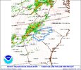
New watch is out.
SEVERE THUNDERSTORM WATCH OUTLINE UPDATE FOR WS 607
NWS STORM PREDICTION CENTER NORMAN OK
430 PM EDT MON AUG 7 2023
SEVERE THUNDERSTORM WATCH 607 IS IN EFFECT UNTIL 1200 AM EDT
FOR THE FOLLOWING LOCATIONS
NCC007-017-019-037-047-051-061-063-065-069-077-079-083-085-093-
101-105-107-117-123-125-127-129-135-141-147-153-155-163-165-167-
181-183-185-191-195-080400-
/O.NEW.KWNS.SV.A.0607.230807T2030Z-230808T0400Z/
NC
. NORTH CAROLINA COUNTIES INCLUDED ARE
ANSON BLADEN BRUNSWICK
CHATHAM COLUMBUS CUMBERLAND
DUPLIN DURHAM EDGECOMBE
FRANKLIN GRANVILLE GREENE
HALIFAX HARNETT HOKE
JOHNSTON LEE LENOIR
MARTIN MONTGOMERY MOORE
NASH NEW HANOVER ORANGE
PENDER PITT RICHMOND
ROBESON SAMPSON SCOTLAND
STANLY VANCE WAKE
WARREN WAYNE WILSON
This forecast might bustBust.
Edit to add I was speaking for my local area not regionally
It's 77 here now. Crazy
Tornado Warning for...
Southeastern Iredell County in the Piedmont of North Carolina...
Southwestern Rowan County in the Piedmont of North Carolina...
* Until 530 PM EDT.
* At 459 PM EDT, a severe thunderstorm capable of producing a tornado
was located 10 miles south of Statesville, or near Lake Norman
State Park, moving east at 50 mph.
HAZARD...Tornado.
SOURCE...Radar indicated rotation.
IMPACT...Flying debris will be dangerous to those caught without
shelter. Mobile homes will be damaged or destroyed.
Damage to roofs, windows, and vehicles will occur. Tree
damage is likely.
* This dangerous storm will be near...
Mooresville around 510 PM EDT.
China Grove and Landis around 520 PM EDT.
Other locations impacted by this dangerous thunderstorm include Mount
Ulla and Doolie.
vsublazer
Member
About to see if that pop up shower is going to help or hurt from early. Sky is getting dark and wind is picking up. Right on Cobb/Paulding border.
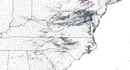
Whatever effect the mountains had of breaking that line up , it’s quickly being overcome. It’s filling back in pretty fast.
HugeSnowStick
Member
This honestly looks like a big ole bust for Atlanta, Radar not real impressive, IMO?

