Most likely. I'm keeping an eye on dews if we don't mix out the HRRR may be substantially underdoneThe Hrrr is unimpressed for us today. I'd bet you're right
-
Hello, please take a minute to check out our awesome content, contributed by the wonderful members of our community. We hope you'll add your own thoughts and opinions by making a free account!
You are using an out of date browser. It may not display this or other websites correctly.
You should upgrade or use an alternative browser.
You should upgrade or use an alternative browser.
SWVAwxfan
Member
I'm under a severe thunderstorm warning. Temps pushing 80 here, which is incredibly warm.
Shaggy
Member
Most likely. I'm keeping an eye on dews if we don't mix out the HRRR may be substantially underdone
I'm still at 86 over 70. The 3k was much wetter for us this afternoon versus the hrrr. Seems those models have been at odds more than a few times this severe season already. Usually the Hrrr is closer to reality in the end.
85/70 here. Good test for summer today with the typically over mixed hrrr vs the too humid 3kI'm still at 86 over 70. The 3k was much wetter for us this afternoon versus the hrrr. Seems those models have been at odds more than a few times this severe season already. Usually the Hrrr is closer to reality in the end.
SWVAwxfan
Member
Getting hammered bad here. Torrential rain, strong winds and nasty lightning. Dropped from 79 to 70 already
SWVAwxfan
Member
It's only 11 after 2 in the afternoon.Wow, we really do suck in NC for storms this year. Storms already falling apart... This is becoming increasingly frustrating. Can't get snow, decent much-needed rain or a decent storm.
Z
Zander98al
Guest
Ready for this possible derecho. going to have my head on a swivel for these qcls naders

Z
Zander98al
Guest
Looks like a spin up in mississippi surprised no tornado warning
Z
Zander98al
Guest
Oof...
It's only 11 after 2 in the afternoon.
Correct and a lot of modeling had a pretty stout line crossing the mountains right around now. We don’t have that on current radar. Classic NC screw job in the making.
Sent from my iPhone using Tapatalk
SBCAPE

Tornado warning in Eastern Alabama.
NBAcentel
Member
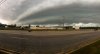
Shelf alert, also some reports of some small hail in Lincolnton 
SWVAwxfan
Member
Yeah. But didn't you hear this is a classic NC screwjob?Shelf alert, also some reports of some small hail in Lincolnton View attachment 83182
Torrential rain here. Roadways are extremely dangerous right now.
I mean 2” hour rates here easily right now
Just appeared tight circulation on this storm
Attachments
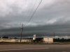
This line of rain is impressive 
What radar are you looking at? It looks to me like a pretty decent line is coming through the foothills now and coming into the Piedmont and down into the upstate. Let’s see what it does. It’s got plenty of unstable air out ahead of it.Correct and a lot of modeling had a pretty stout line crossing the mountains right around now. We don’t have that on current radar. Classic NC screw job in the making.
Sent from my iPhone using Tapatalk
Z
Zander98al
Guest
Storm to the right of it's getting a tight rotation too
B
Brick Tamland
Guest
85/70 here. Good test for summer today with the typically over mixed hrrr vs the too humid 3k
Really ridiculous if we can't get any storms out of today's weather.
Also storm cells developing out in front of main systemWhat radar are you looking at? It looks to me like a pretty decent line is coming through the foothills now and coming into the Piedmont and down into the upstate. Let’s see what it does. It’s got plenty of unstable air out ahead of it.
What radar are you looking at? It looks to me like a pretty decent line is coming through the foothills now and coming into the Piedmont and down into the upstate. Let’s see what it does. It’s got plenty of unstable air out ahead of it.
It does look better than it did a while ago but still not as impressive as I would of thought. Especially, given the CAPE. But yes, you’re correct. Let’s see what this thing does.
Sent from my iPhone using Tapatalk
Z
Zander98al
Guest
That south alabama and mississippi area. Is very concerning for a derecho. Not looking good for that area. Derecho composite is pretty high as well
RollTide18
Member
That south alabama and mississippi area. Is very concerning for a derecho. Not looking good for that area. Derecho composite is pretty high as well
Oddly enough we dealt with a derecho on May 3, 2009.
Gutters annihilated. This is the hardest I’ve seen it rain since February 6, 2020
0.98” for the day and counting. Probably had 4-5in/hr rates when that shelf rolled thru
Z
Zander98al
Guest
Looks like the derecho has already formed. Some very high winds in north missisppi from this
Massive cluster of multicell thunderstorms are now developing in a big way to our west ... wow definitely not seen from the HRRR
Even a severe warning now 
norcarolinian
Member
Nasty storm moving through northern Guilford right now
Tornadocane
Member
After the rain dissipates, the hardest hit areas will get a break until Sunday. Then it looks like rain is on the menu for the rest of the foreseeable future. Flooding will likely be the story of the day and month.
smast16
Member
Lightening / Thunder and heavy rain back at the house. Not there right now, but I can see it and hear it on the Ring.
Probably about to get a TW near Brent.
Z
Zander98al
Guest
Tornado warning?Probably about to get a TW near Brent.
Z
Zander98al
Guest
Uh oh outflow boundary in georgia. Gotta watch and see the interactions with storms on that.
JHS
Member
Up to 1.11 for the 2 days here.