I’m 80miles ahead of the line and that cell built right on top of me loaded with lightning. Wild
-
Hello, please take a minute to check out our awesome content, contributed by the wonderful members of our community. We hope you'll add your own thoughts and opinions by making a free account!
You are using an out of date browser. It may not display this or other websites correctly.
You should upgrade or use an alternative browser.
You should upgrade or use an alternative browser.
Severe Severe Threat Jan 11-13 2023
- Thread starter SD
- Start date
This is not a good time for GSP radar to be down…
Nasty cell NE of Sparta GA

mydoortotheworld
Member
I saw that warning and was pretty confused when it was issued, didn't see anything that was obvious on velocity/CC but figured observed supersedes radarSo not to be that guy… but was the Atlanta Tornado warning based off a false report? Cause I didn’t see much on radar or CC but it said observed!
Probably good they issued it though just to be safe! I was driving though so might’ve missed it their was radar confirmation
bigstick10
Member
Timmer should have kept coming West.
Ron Burgundy
Member
New tornado warning for Stockbridge SE of ATL
njbarrineau
Member
This is not a good time for GSP radar to be down…
Not at all. Here we go Super Doppler 4?

Sent from my iPhone using Tapatalk
It surprised me when I saw it but maybe they’re just being over-cautious after what has transpired in Alabama todayI saw that warning and was pretty confused when it was issued, didn't see anything that was obvious on velocity/CC but figured observed supersedes radar
Psalm 148:8
Member
- Joined
- Dec 25, 2016
- Messages
- 345
- Reaction score
- 792
Cell that came out of East Alabama, died as it was heDing for us and kids around 315pm..reformed south of LaGrange and powered up across middle Troup into western meriwether county GA. Still here at school with kids.
NoSnowJoe
Member
The tornado that formed around Lagrange went about 4-5 miles south of me, about to head down there to see if I see any damage.
- Joined
- Jan 5, 2017
- Messages
- 3,794
- Reaction score
- 6,035
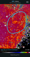
There is no sign of any spin near Stockbridge. Wait, you can see a small a spin. Just west of Stockbridge. From kjgx you can see it.New tornado warning for Stockbridge SE of ATL
Last edited:
Nerman
Member
Griffin HS debris field, over 100mph winds
Bad one near Griffin, GA
NBAcentel
Member
Twins it looks like
FFC is slow on this. It’s outside the polygon 
Yeah, big winds and lightning ran me off the front porch. A good test of the whole house lightning protectors I put in last summer.
- Joined
- Jan 2, 2017
- Messages
- 1,566
- Reaction score
- 4,279
Nothing like a January hailstorm...dam!

Oh crap. My nerves are gone at this point. I'll be curled up in the bathtub soon.
NBAcentel
Member
Some pretty nice hail in the upstate with this linear stuff 
Darklordsuperstorm
Member
What a day. A storm that is behind the line has now produced a tornado in North Alabama. Insanity.
Darklordsuperstorm
Member
So. With the way today has gone. Does that mean the snow flurries tomorrow are going to turn out to be a full on winter storm? ?
D-Ray
Member
marble size hail with .77 in the rain gauge... .lucky the hail only lasted a minute
dsaur
Member
Hey, could some of ya'll provide me with some links to decent non pay radar sites for tracking tornadoes, please? I've lost all my links from a hd crash, and I was just staring down the barrel of a long lived twister, and when it was on me the only way I could tell were it was was by the color of the sky and the thunder, and that's not good enough, lol. I tracked it out of Ala when it was warned for LaGrange, that's my heads up city, for the usual sw/ne tracks. When the weather radio gave me a pin point position relative to Greenville I could tell it would most likely track south of me and it did, but it got tense when the rain fell in buckets and it was just about pitch dark. I looked but if if was out there it would have been rain wrapped. I just want an updated position, without watch overlays, and too bold county lines, and won't zoom, and too general, blah, blah, blah. An overlay that hides the radar, or clogs the whole screen with warning boxes, and storm tracks all heading nw to se is worthless. Many thanks.
iGRXY
Member
Serious rain and wind in this line
NBAcentel
Member
Lol wtf 
rburrel2
Member
Seems like this could have/should have been a moderate day.
Ron Burgundy
Member
Getting dark
Darklordsuperstorm
Member
It certainly would have verified as such.Seems like this could have/should have been a moderate day.
bigstick10
Member
It is sunset,,,LOLGetting dark
Darklordsuperstorm
Member
Seeing some images of the Selma tornado that show a horizontal vortice with it. Usually an indicator of a particularly strong tornado.
Well this looks less than ideal 
Definitely some rotation
FML