DadOfJax
Member
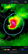
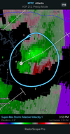
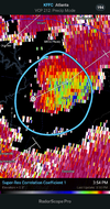
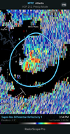
So thinking that the outflow is essentially creating a strong push of inflow from the SE due to the displacement of air around it? I'm assuming this would be considered one of those rare micro climate TOR's. Please correct me if I'm interpreting wrong.Have to wonder if at least for a short period of the outflow pushing to its south is helping maintain since it looks to be accelerating the SSE flow just in front of the ofb which is feeding indy the inflow