Z
Zander98al
Guest
I'm going to be pretty aggravated if everything starts popping off at my bedtime around 8 or 9. Because I'm not going to be able to get any sleep

Lightning picking up with these and the storm down close to Amory MS tooLot of rotations View attachment 114246
 Weak rotation over Shoals, severe warned. This must have been the cell the HRRR UH track picked up

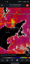
Tornado warned now! Strong rotation
 Looks to stay north of Athens, which would be great to avoid more populated city. Brad Travis said tornado debri possible on radar, not well defined though so he didn’t confirm. Coxey in 5 minutes
Definitely a TDS now. Looking and lined everything up. That's a damaging tornado, now it lifted it looks like. Probably up and downApparently there has been power flashes observed at one point according to Fred (Gossage).
 New one possible here,
Lol I wake up at 3:30 I'f I feel like I can go to sleep and be safe I'm going to ?You going to hype this up and go sleep?

Looks like this storm may have produced a brief tornado near Hazel Green.Madison county storm just went tornado warned again. Circulation tightened back up a little bit.View attachment 114257
That area near Courtland needs a warning!


 VIL is weaker, no circulation defined, just a good storm.