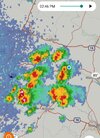
Storms moving through central NC look very mean .. almost a grouping of super cells. Don’t seem to be weakening at all
-
Hello, please take a minute to check out our awesome content, contributed by the wonderful members of our community. We hope you'll add your own thoughts and opinions by making a free account!
You are using an out of date browser. It may not display this or other websites correctly.
You should upgrade or use an alternative browser.
You should upgrade or use an alternative browser.
Severe Severe Thread May 4-6
- Thread starter Detective WX
- Start date
Shaggy
Member
Yeah once they started bubbling I've got towers starting all over. Wouldn't be surprised to see a big multicellular cluster pop over the coastal plains soon.83/73. Feels unstable.
BHS1975
Member
Rotation

Sent from my iPhone using Tapatalk

Sent from my iPhone using Tapatalk
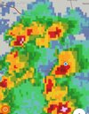
Thinking a merger happens with these bottom cells .. northern cell is taking off .. should be tornado warned soon enough baring any changes 
As soon as we got a little bit of sun things started popping. Looks like that's all we needed to light the fuse.
Still just scattered cumulus here. Cluster to my SW will like miss me just to the NW, unless we see development on the SE side.Yeah once they started bubbling I've got towers starting all over. Wouldn't be surprised to see a big multicellular cluster pop over the coastal plains soon.
Any chance the storms we're seeing pop up now could keep the second round we're supposed to get later from being as bad?
Checking out the radar from further away you can see these cells are continuing to develop high up in the atmosphere which will translate to the surface soon.. these could mean business
Shaggy
Member
Didn't take but a second man. Hearing thunder at work now.Still just scattered cumulus here. Cluster to my SW will like miss me just to the NW, unless we see development on the SE side.
Attachments
bigstick10
Member
What an UTTER BUST of a forecast IN ATL area.
That storm south of Warner Robins has some serious wind 
Shaggy
Member
Good storm right now some solid wind
Bannerdude
Member
Some rotation showing up in the velocity scan on the cell moving NE through Pittsboro
Shaggy
Member
Shaggy
Member
MichaelJ
Member
Tornado Warning in Winston, Lewisville, East Bend, Vienna and surrounding areas. If you are driving seek shelter immediately. If you have a basement go there quickly, if you don't have a basement seek an interior room and stay there, if caught in the open find the nearest substantial building and take shelter immediately
Bannerdude
Member
We had a few minutes of pea-sized hail with a few nearly dime sized in Moncure
GarnerNC
Member
Pretty impressive how close this thunder sounds considering the heart of it is over Morrisville at this point.
thekidcurtis
Member
Pretty impressive how close this thunder sounds considering the heart of it is over Morrisville at this point.
It’s been 1 constant rumble for 3min straight here at the airport.
Sent from my iPhone using Tapatalk
jay.p
Member

GarnerNC
Member
Isn't this the same area that had some brief rotation like a month ago or so?
RDUHeatIsland
Member
Dime-sized hail in Cary
Steven_1974
Member
Man, it was rough here for a bit at the edge of RTP. No idea how fast the wind was blowing but had to been over a 60 MPH gust. Some hail came down too.
Shaggy
Member
Storm.number two but we aren't maturing like the storms out west. Decent storms but nowhere near severe
Steven_1974
Member
Yeah pretty close to where trees and a building got tore up a bit. I think it was a Pfizer building.Isn't this the same area that had some brief rotation like a month ago or so?
Drscottsmith
Member
Sun has been out for a couple of hours now in upstate near Spartanburg. Not at home to check the numbers...
blueheronNC
Member
Would be surprised if this storm now moving out of the Triangle doesn't have the best chance to drop a spin. It seems to be the most mature while having the cleanest inflow. Surprised it hasn't tightened up yet.
That is definitely the one to watch and almost on the same path HRRR was showing UH track earlierWould be surprised if this storm now moving out of the Triangle doesn't have the best chance to drop a spin. It seems to be the most mature while having the cleanest inflow. Surprised it hasn't tightened up yet.
Ruh roh

Shaggy
Member
Drizzle Snizzle
Member
Reed Timmer chasing a tornado in upstate SC !
Downeastnc
Member
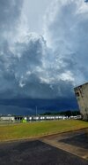
Decent storm

Slater Marietta hunker down. Incoming
blueheronNC
Member
Slater Marietta hunker down. Incoming
Reed Timmer seems to be overselling this one a bit. Radar doesn't look tight.
Incoming hail core into the Augusta area 
blueheronNC
Member
Chasing in the southeast is ridiculous. Watching Reed Timmer's feed. Best in the business and these roads are impossible to keep up with anything.
HSVweather
Member
Good call by SPC with the big Enhanced risk area.
Shaggy
Member
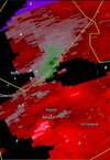
Eastern NCcell now tornado warned
njbarrineau
Member

Skies looked wicked towards that Northern Greenville County cell from TR
Sent from my iPhone using Tapatalk