BufordWX
Member
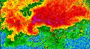
Heading right for Seminole. Big trouble if it is still down.


May get a tornado warning soon.Storm southeast of OKC is attempting to organize again. Heading over the path of the first storm as well.

May get a tornado warning soon.View attachment 118078


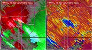
Not good if this is true View attachment 118087


Noticed the 12z HRRR run had decent supercellular development in the new enchaned area. Maybe yall get some action tooView attachment 118115
..NC INTO VA
MODELS INDICATE A SURGE OF LOW-LEVEL MOISTURE WILL OCCUR ACROSS NC
AND INTO VA DURING THE DAY, COINCIDENT WITH HEATING. MUCAPE IN
EXCESS OF 2000 J/KG IS FORECAST BY SEVERAL MODELS, WITH HODOGRAPHS
CLEARLY FAVORING SUPERCELLS. EFFECTIVE SRH OF 200-300 M2/S2 AND
68-70 F DEWPOINTS WILL ALSO FAVOR A TORNADO RISK. AS CONFIDENCE
INCREASES FOR THIS SCENARIO REGARDING STORM COVERAGE, A CATEGORICAL
UPGRADE COULD BE NEEDED IN LATER OUTLOOKS.