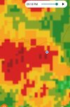
• Hello, please take a minute to check out our awesome content, contributed by the wonderful members of our community. We hope you'll add your own thoughts and opinions by making a free account!

Severe Severe Thread May 4-6

Yeah, I think it all depends on who sees the sun. Guess that's why the SPCwent with the large level 3 area to cover their butts.
Don’t think many see sun today but that doesn’t mean you won’t see severe weather, much more go into the atmosphere to get severe weather. If we had sun as well into the equation this would be a much more dangerous day for many more people
 
Greenwood County Schools in Upstate SC are dismissing early


Sent from my iPhone using Tapatalk
I was curious if we’d see early dismissals. Seems like we saw this the last time we saw a large level three threat with similar timing.
 
Greg Fishel doesn't seemed too impressed with the severe chance.

VERY COMPLEX SITUATION-HAVE TO BE CAREFUL HOW I WORD THIS

The Storm Prediction Center, the incredible group of men and women who monitor the entire country looking for potential severe weather threats, has our area in what they call an "Enhanced" risk today. This equates to a Level 3 on a scale of 1 to 5. So what I am about to say is NOT intended to undermine their forecast. I'm just trying to point out that there are numerous competing factors that make this anything but a slam dunk severe weather outbreak.

First, the low level wind shear forecasts for early to mid afternoon are simply not impressive at all. That leads me to believe that the tornado threat this afternoon is not all that high. The only positive factor is a warm front that will be lifting northward across the region during the afternoon. There is always at least somewhat favorable low level wind shear along and just north of the warm front, so that is one thing to watch.

Then later this afternoon, drier air aloft begins to move in, and as the atmopshere becomes well mixed, that drier air will work its way down to the surface, thus lowering our dewpoints. That would imply a break in any thunderstorm activity until this evening, say around 8pm or so.

Between 8pm and 10pm, a cold front will traverse the area, and while the low level wind shear will be more favorable, the instability will have decreased. After 10pm, the threat of any severe weather will pretty much be gone.

And by the way, the transition to much cooler temperatures has been pushed back, so Saturday's temperatures will still reach the 70s, and the noticeable drop in temps won't occur until Saturday night.

Again, it is always better to be safe than sorry. If you prepare and nothing happens, don't be mad, be thankful!
 
Warm front through here with a solid temp and DP jump.
 

Attachments

  • Screenshot_20220506-123151_Samsung Internet.jpg
    Screenshot_20220506-123151_Samsung Internet.jpg
    265.8 KB · Views: 8
animate.png


Cloud cover seems to be thinning?
 
And Wake County schools sent an email saying they will just hold the students in the schools if there are severe storms during dismissal instead of dismissing early. ?‍♂️
 
Back
Top