Snooze fest for the Atlanta to Macon corridor
-
Hello, please take a minute to check out our awesome content, contributed by the wonderful members of our community. We hope you'll add your own thoughts and opinions by making a free account!
You are using an out of date browser. It may not display this or other websites correctly.
You should upgrade or use an alternative browser.
You should upgrade or use an alternative browser.
Severe Severe Thread May 4-6
- Thread starter Detective WX
- Start date
Saw some limbs and thin branches down coming home from the storm that rolled through here. Nothing major.
NoSnowATL
Member
Dry slotted. Felt like winter.Snooze fest for the Atlanta to Macon corridor
Sun is out here again. Wonder if we'll get another round later. TWC app says more storms here around 8:30.
Last edited:
All clear here. Everything blew up to my south and East ?? decent rain totals here today as well. Win
Wish I could get a decent hail core to move over MBY. Daddy needs a new roof
Trying to get organized

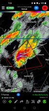
This thing has verified today .. strong tornado signature currently with the mebane storm .. confirmed tornado with that one .. saw quarter sized hail with the supercell in wake county in apex today .. biggest I’ve ever seen and a cool Shelfie as well .. great day so far 


Pretty much a dud here, best one missed to my NW, .1 rain. Next
Sounds like a tornado might have hit near Mebane.
- Joined
- Jan 23, 2021
- Messages
- 4,590
- Reaction score
- 15,179
- Location
- Lebanon Township, Durham County NC
Looks likely a tornado touched down in Mebane
Heard the same, just spoke to a guy at a bar in Hillsborough whose some lives in Mebane saying there's reports of structural damageSounds like a tornado might have hit near Mebane.
Yeah, not a widespread event by any means yet. Reminds me of the event when the tornado hit in RTP at the end of March, and we were less than a level 3 threat then.Pretty much a dud here, best one missed to my NW, .1 rain. Next
That was all the warm front stuff .. now here comes all the severe thunderstorms for others .. widespread down south and east of us .. should continueYeah, not a widespread event by any means yet.

Looks like a lot more action and more coverage in SC than we had in NC.That was all the warm front stuff .. now here comes all the severe thunderstorms for others .. widespread down south and east of us .. should continueView attachment 118204
WRAL showing round 2 coming through here around 9:00.
What happened to all the mixing? 79/71 still.
Shaggy
Member
Storms constantly refiring from Goldsboro to rocky mountWhat happened to all the mixing? 79/71 still.
Yeah got one popping right on top of me, think I spoke too soon earlierStorms constantly refiring from Goldsboro to rocky mount
SWVAwxfan
Member
All hell is breaking loose in Christiansburg from a severe thunderstorm
aldamon
Member
BHS1975
Member
What happened to all the mixing? 79/71 still.
Got some to the southeast in the low 60s just like the HRRR was showing a bit ago.
Sent from my iPhone using Tapatalk
SWVAwxfan
Member
They are saying confirmed tornado near Wentworth NC
SWVAwxfan
Member

Earlier official reports .. and we still continue

This is a verified enhanced severe weather day.
HSVweather
Member
SWVAwxfan
Member
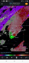
Even the NRV of Virginia is seeing enhanced level weather.View attachment 118206
Earlier official reports .. and we still continue View attachment 118208
This is a verified enhanced severe weather day.
HSVweather
Member

Confirmed large and damaging tornado
Downeastnc
Member
Confirmed large and damaging tornado
Big CoC drop for a few frames
iGRXY
Member
Other than a 5 minute shower, it was a complete dud
SC has had more coverage than NC, though. Really scattered and isolated here.Other than a 5 minute shower, it was a complete dud
Shaggy
Member
My county has had 3 severe storms todaySC has had more coverage than NC, though. Really scattered and isolated here.
Getting lightning and thunder now.
Well, one flash of lightning and rumble of thunder, that's it.
D
Deleted member 609
Guest
Curse of the watch got you againWell, one flash of lightning and rumble of thunder, that's it.
Shaggy
Member
Strong storm number 4 approaching me