12z NAM is still nasty for Louisiana.

That 12z nam really sowed the system down for sunday. Increasing the threat area and severity. Helicty is super high. For alabama


View attachment 18753
North GA sounding per 12Z NAM 11AM
Last time i had a tornado threat at night in my area was 7 years ago killed a girl down the street. Deaths rise when it becomes night events unfortunately. Because everybody shrugs it off and sleeps.I'm very nervous about the nocturnal threat for Saturday night.
You must be in the Trussville area. That was a terrible storm at night. Several of my co-workers were directly hit and had moderate to severe damage to their homes. Because it was night, they said the confusion and darkness made it worse. The you girl being killed was just awful. A lot of people had no idea there was a tornado warning. That is why weather radios or phone alarms are a must.Last time i had a tornado threat at night in my area was 7 years ago killed a girl down the street. Deaths rise when it becomes night events unfortunately. Because everybody shrugs it off and sleeps.
Clay chalkville/ center point area. It was awful. My great grandmother was hit, grandmother was hit, and my cousins. Id woken up to the winds roaring but didn't think about it. It was awful. And exactly everybody needs a weather radio.You must be in the Trussville area. That was a terrible storm at night. Several of my co-workers were directly hit and had moderate to severe damage to their homes. Because it was night, they said the confusion and darkness made it worse. The you girl being killed was just awful. A lot of people had no idea there was a tornado warning. That is why weather radios or phone alarms are a must.
How much has it slowed down they still saying early morning here ....Dang this system slowed down. Looks pretty bad over alabama instability of 2000+ with that amount of shear ?
Local offices don’t change risk. Just fyiLooks like nws of bham is waiting for a few more high res model runs to come through before they increase central alabama to enhanced risk. According to there discussion page.
Dang this system slowed down. Looks pretty bad over alabama instability of 2000+ with that amount of shear ?
Idk tbh may change but around 9 o'clock. And then 3 oclock? Looks like the nam wants to have two waves for alabama one with more instability and one with more shear.How much has it slowed down they still saying early morning here ....
I meant for there risk maps not spc my bad.Local offices don’t change risk. Just fyi
They do for their local areas. Currently Birmingham office has their coverage area under a slight risk for Sunday and as said mentioned waiting for additional models to consider upgrading.Local offices don’t change risk. Just fyi
Idk tbh may change but around 9 o'clock. And then 3 oclock? Looks like the nam wants to have two waves for alabama one with more instability and one with more shear.
They do for their local areas. Currently Birmingham office has their coverage area under a slight risk for Sunday and as said mentioned waiting for additional models to consider upgrading.
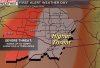
I am kind of ignorant but it seems to me that this is saying something different than the NWS Huntsville's AFD.First alert from 48
News stations don't follow threat areas or severe risks that nws offices put out. They can sometimes be different.I am kind of ignorant but it seems to me that this is saying something different than the NWS Huntsville's AFD.
I am kind of ignorant but it seems to me that this is saying something different than the NWS Huntsville's AFD.