• Hello, please take a minute to check out our awesome content, contributed by the wonderful members of our community. We hope you'll add your own thoughts and opinions by making a free account!

Pattern September 2024

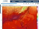
Not gonna lie, the Euro and AI Euro are making me excited. Can we get three nice Septembers in a roll?

It's been hot here the last couple years. Looking better this year so far

I'm watching that as we head to winter because above normal temps dominated obviously
 
Starting tomorrow, the heat is in retreat! The air temperatures for the next couple of weeks are going to be very comfortable for early September. The ninety degree days will not be missed. Towards the end of the period on the GFS there were a couple of days where the RDU area was getting close to ninety but that is still tolerable for this time of year.
 
Happy met. autumn!!
The Pumpkin Dance Dancing GIF by Halloween
 
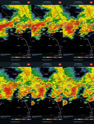
The National Weather Service in Raleigh has issued a

* Severe Thunderstorm Warning for...
Northwestern Nash County in central North Carolina... Northeastern Wake County in central North Carolina... Franklin County in central North Carolina...

* Until 415 PM EDT.

* At 333 PM EDT, a severe thunderstorm was located near Wake Forest, or 11 miles southwest of Louisburg, moving east at 20 mph.

HAZARD... 60 mph wind gusts.

SOURCE... Radar indicated.

IMPACT... Expect damage to roofs, siding, and trees.

* Locations impacted include...
Louisburg, Wake Forest, Bunn, Rolesville, Spring Hope, Youngsville, Castalia, Centerville, Pilot, and Purnell.
 
The National Weather Service in Raleigh has issued a

* Severe Thunderstorm Warning for...
Southern Wake County in central North Carolina...
Northwestern Johnston County in central North Carolina...

* Until 430 PM EDT.

* At 343 PM EDT, a severe thunderstorm was located over
Fuquay-Varina, or 11 miles south of Cary, moving northeast at 30
mph.

HAZARD...60 mph wind gusts.

SOURCE...Radar indicated.

IMPACT...Expect damage to roofs, siding, and trees.

* Locations impacted include...
Raleigh, Cary, Garner, Fuquay-Varina, Clayton, Zebulon, Holly
Springs, Knightdale, Wendell, and Lake Wheeler.
 
I've been seeing **yellow Butterflies**, Here on the coast, Which means , Spot/Fishing season is almost here along with cooler Temps..

@Shaggy, Usually they don't appear until Mid~Sept or October ..

They are flying now, (Early Fall)??

In fact SPOTS were reported to be caught off the piers here, (Not alot) though they are starting too move & bite..
We saw countless of them today coming back up Green swamp Road. They are like a neon yellow. Never seen that color before.
 
Not sure what the point of watches are anymore. No watch today but plenty of severe storm warnings. And then we have times where there are watches and it ends up less active than days like today. Maybe we would be fine with just issuing warnings.
 
I've been seeing **yellow Butterflies**, Here on the coast, Which means , Spot/Fishing season is almost here along with cooler Temps..

@Shaggy, Usually they don't appear until Mid~Sept or October ..

They are flying now, (Early Fall)??

In fact SPOTS were reported to be caught off the piers here, (Not alot) though they are starting too move & bite..
We caught a few spot off the pier in southport back in mid July. Saw some flounder right on the beach today at CB boardwalk. They were right up against drop at shore. Water was not the typical bath water. Almost felt chilly
 
We caught a few spot off the pier in southport back in mid July. Saw some flounder right on the beach today at CB boardwalk. They were right up against drop at shore. Water was not the typical bath water. Almost felt chilly
Let the cooler temperatures settle in for a couple of weeks that are forecast and things should really pick up along the coast. October is usually when the spot start running around the piers. It's a shame that if you catch one of those flounder you would have to throw it back with the new recreational fishing limits.
 
We caught a few spot off the pier in southport back in mid July. Saw some flounder right on the beach today at CB boardwalk. They were right up against drop at shore. Water was not the typical bath water. Almost felt chilly

Yeah I noticed the water wasn't as warm as it usually is but the maps are still showing above normal SSTs.


Sent from my iPhone using Tapatalk
 
The humidity was off the charts this morning and the rain gauge had 2.15 inches of rain from yesterday and the storms that came through overnight. Cutting the yard was like exercising in a humidor. Once the cold front rolls through and we start feeling the effects, the weather should be delightful for this time of year through the rest of the week.
 
The humidity was off the charts this morning and the rain gauge had 2.15 inches of rain from yesterday and the storms that came through overnight. Cutting the yard was like exercising in a humidor. Once the cold front rolls through and we start feeling the effects, the weather should be delightful for this time of year through the rest of the week.
That's why I didn't work in the yard today. Going to wait until it dries out some and the temps and humidity are lower later this week.
 
I see the Euro has caved to the Icon with the end of the week system.

What is with this relentless ridge? The folks in the southern gulf states must be in record territory for summer heat by now.

1725313941393.png

Mobile, AL
1725314171281.png

Their average high for August was 5.3 degrees above average, that is pretty remarkable for a summer month.
 
Last edited:
Gonna put the cart on front of the hoarse here.
But I cant recall Summer shuting down this early ever. Hopefully its an omen to a good winter.
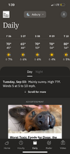
Since mid August, minus last weeks mini heat wave, summer is gone. We will have to fight to cross 70 today. Dew points will bump up late week and help it rain late Fri into Sat. Then next week we will have DPs in the mid 40s all week, behind Saturdays rain. After that its already mid September. Jury is out,but my local usually is past the heat and Humidity by mid Sept.
 
We had hotter days last summer but this summer has been a steady oven even overnight.
That ridge parked over the gulf states gives us the worst summers. Places like CAE haven’t had it as near as bad this season.
 
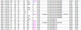
More of the same BS from KATL's sensor just like RDU's. This was last Saturday. Here are the recorded high temperatures:

KATL: 96
KPDK: 91
KFCC: 91
KFTY: 92

The high at KATL was probably 91 or 92, but whatever happens during the time to make it go from 91 to 97 in 15 minutes, then right back down to 91 minutes later causes these egregious readings, and they just go with it. I cannot understand it.

1725472146697.png
 
More of the same BS from KATL's sensor just like RDU's. This was last Saturday. Here are the recorded high temperatures:

KATL: 96
KPDK: 91
KFCC: 91
KFTY: 92

The high at KATL was probably 91 or 92, but whatever happens during the time to make it go from 91 to 97 in 15 minutes, then right back down to 91 minutes later causes these egregious readings, and they just go with it. I cannot understand it.

View attachment 150688

This link says the high of 96 on 9/1/24 at KATL was at 1:56PM. This is odd. Do you have the every few minute data for, say, 1PM to 2:10PM?

THE ATLANTA CLIMATE SUMMARY FOR SEPTEMBER 1 2024

VALID TODAY AS OF 0400 PM LOCAL TIME.

CLIMATE NORMAL PERIOD: 1991 TO 2020
CLIMATE RECORD PERIOD: 1878 TO 2024

WEATHER ITEM OBSERVED TIME RECORD YEAR NORMAL DEPARTURE LAST
VALUE (LST) VALUE VALUE FROM YEAR
NORMAL
...............................................................

TEMPERATURE (F)
TODAY
MAXIMUM 96 1:56 PM

—————-
Here I’ve had no measurable rainfall since way back on 8/20! That’s after an extremely wet prior ~30 days.
I’ve had no measurable rainfall in over 30 days. I think that will change on Friday though.
 
Back
Top