• Hello, please take a minute to check out our awesome content, contributed by the wonderful members of our community. We hope you'll add your own thoughts and opinions by making a free account!

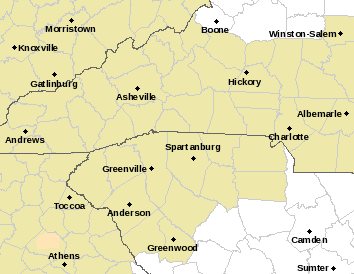
Wintry Saturday 12/17 light ice threat

Status
Not open for further replies.
If this morning was any precursor or indicator...there were numerous cars off the road in Ashe, Watauga, and Wilkes Counties due to freezing drizzle and fog. And now this arctic blast will be even colder on top of adding communities that are less skilled (if there is skill of driving on ice) into the mix.

Therefore, Brick, I have no doubt this event will likely be greater than next week due to the surface conditions being more supportive at least at this time.

Next week event, if there is one, seems a bit different esp. for RAL seeing how they could see 60s and 70s that will have an affect on surface conditions.

I hope all that makes sense.

- Casey
 
Certainly can't rule out a few flurries/sleet pellets on the very front edge of this system esp north of HWY 64...

namconus_ref_frzn_seus_44.png
 
NWS MEG mentions all snow for my neck of the woods, if the cold air can catch the precip in time. As of now, Saturday night shows "snow likely" here in Paris TN, with a high Sunday of 27. Obviously not a classic setup for much snow, but not an ice threat here either.
 
Sorry guys if this sounds redundant, but does anyone have a qpf map from euro showing precip in 6-12hr increments for hrs96-114. Thanks For arkansas area
 
NWTENN link said:
NWS MEG mentions all snow for my neck of the woods, if the cold air can catch the precip in time. As of now, Saturday night shows "snow likely" here in Paris TN, with a high Sunday of 27. Obviously not a classic setup for much snow, but not an ice threat here either.
The funny thing is the models show more freezing rain and sleet for west and middle tn than they do snow.
 
SREF plumes are slowly increasing ZR chances for a good part of central/west NC. GFS looks similar to 6z
 
SD link said:
SREF plumes are slowly increasing ZR chances for a good part of central/west NC. GFS looks similar to 6z
If we can get enough moisture to make it to the ground , the western Carolinas could be pretty rough!
 
Only thing is it will be so dry I wonder how long it will take for precip to actually reach the ground.
 
Alright so I did a little markup on the experts analysis from the WPC.

The guys there are not local but they still generally know their CAD business. I will be watching this climo area closely in case extra moisture can find its way to the surface there sooner and in abundance. The mountains here (even Stone Mountain and the Brushy Mountains in the foothills) help keep the cold rain intrusions at bay a little longer. I could go a little more in detail for the foothills but that would really be very microclimate backyard junk so just keeping in general.

15442386_146231292527246_1371389097479042750_n.jpg
 
Supershow link said:
Hour 78
dc913bf3413867ec4b457aa492c49343.jpg


Sent from my iPhone using Tapatalk
Not much to show from 12Z after this point for this time period...cold push not quite as much to the south (couple degrees warmer)
 
Mrgolf link said:
Sorry guys if this sounds redundant, but does anyone have a qpf map from euro showing precip in 6-12hr increments for hrs96-114. Thanks For arkansas area
09663cd2bc1e84db2c5606aea8d82c78.jpg
fd5434665967646139db33c7955cbee7.jpg
a0e1f785c6ada34d4339345108aba2cc.jpg


Sent from my SM-G900V using Tapatalk
 
Almost all guidance thus far (minus the NAM) looks warmer in their 12z runs, although I'm not entirely sure how much I buy that. Eventually, given the lack of large, sprawling surface high over New England, & tremendous WAA, the in-situ wedge will erode & temps (especially in the coastal plain & piedmont) should spike into the 60s, but they may be forecasting this to occur a little too quickly (as usual)...
 
12z euro has very light moisture in western NC early Saturday am

Sent from my SM-G900V using Tapatalk
 
12z Euro a tick colder maybe for W NC and NE GA early Sat
LP 3 millibars lower - a little slower - avg 2 or 3 degrees warmer up stream behind front
 
Saturday morning will be very interesting, especially for my area (I'm right on the fringe of the freezing line) from these maps. I'm guessing if the precip can lock the cold air in, there will be an incredible temperature gradient on Saturday afternoon between say Atlanta and Gainesville as the strong WAA surges NEward through Atlanta and puts up a fight with the wedge. In this kind of situation, the battle zone for the wedge is often around the northern perimeter or a little north of there. There will likely be 60s on the south side and 30s on the north side.
 
Status
Not open for further replies.
Back
Top