Belle Lechat
Member
- Joined
- Aug 29, 2021
- Messages
- 715
- Reaction score
- 526
Almost there!Highlighting this line
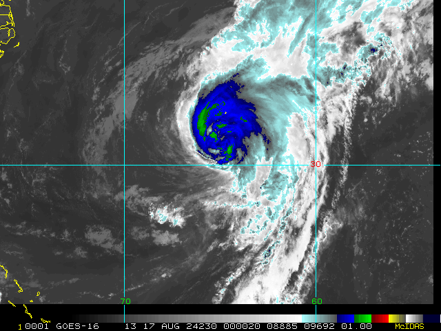
1200UTC 15.08.2024 84 22.7N 71.1W 1006 43
43 kts=49.48 mph
Let's see how long it really takes to go up 3 knots.
the lack of a well-defined center means it will remain a potential tropical cyclone for this advisory.
| 1 | 08/11 5:00 PM | 13.6N | 48.0W | 30MPH | 1010mb | Wnw at 21 MPH | Ptnl | Five | 08/11 4:57 PM | Hagen/cangialosi |
| 1A | 08/11 8:00 PM | 13.9N | 49.1W | 30MPH | 1009mb | Wnw at 23 MPH | Ptnl | Five | 08/11 7:45 PM | Pasch |
| 2 | 08/11 11:00 PM | 14.1N | 50.1W | 30MPH | 1009mb | Wnw at 23 MPH | Ptnl | Five | 08/11 10:45 PM | Pasch |
| 2A | 08/12 2:00 AM | 14.3N | 51.4W | 30MPH | 1009mb | Wnw at 23 MPH | Ptnl | Five | 08/12 1:36 AM | Beven |
| 3 | 08/12 5:00 AM | 14.4N | 52.5W | 30MPH | 1009mb | W at 25 MPH | Ptnl | Five | 08/12 4:54 AM | Beven |
| 3A | 08/12 8:00 AM | 14.6N | 54.3W | 30MPH | 1009mb | W at 26 MPH | Ptnl | Five | 08/12 8:00 AM | Reinhart |
| 4 | 08/12 11:00 AM | 15.1N | 55.6W | 35MPH | 1010mb | W at 26 MPH | Ptnl | Five | 08/12 11:03 AM | Reinhart |


Fishy storm. So far we have been lucky this year with only 2 systems impacting the US.
Yeah, we still have September to get through, which is the peak season. Hopefully it will be like last year with the systems going out to sea.The US having already had 2 hurricanes hit by early August is tied for 2nd highest on record back to 1851. Only 1886 had more. Not a good sign of things to come.
Bermuda is at risk for a hit from Ernesto.

I've never seen a creepy-looking storm.
That’s 50%Fishy storm. So far we have been lucky this year with only 2 systems impacting the US.
Fishy storm. So far we have been lucky this year with only 2 systems impacting the US.