Please change the title to tropical storm Ernesto.
Tropical Storm Ernesto Discussion Number 5
NWS National Hurricane Center Miami FL AL052024
500 PM AST Mon Aug 12 2024
Satellite images and data from the Air Force Hurricane Hunters
indicate that a center of circulation has now formed, and deep
convection is gradually organizing in bands around that feature. A
combination of flight-level wind and SFMR data from the aircraft
support increasing the winds to 35 kt. Since the system meets the
definition of a tropical cyclone and has winds of tropical storm
force, it is now designated Tropical Storm Ernesto.
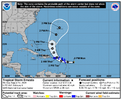
Based on the latest satellite images and aircraft data, the center
has formed about 30 n mi north of the previous track. This makes
the initial motion uncertain, but our best estimate is 285/24 kt.
This fast forward speed is due to a strong low- to mid-level ridge
situated just north of the system over the subtropical Atlantic. A
fast west-northwestward motion is expected to continue, taking the
storm across the northern Leeward Islands overnight and near or over
the Virgin Islands and Puerto Rico Tuesday afternoon or Tuesday
night. After that time, a significant slowdown and a turn to the
north over the Atlantic is expected as a deep-layer trough pushes
off the U.S. east coast, causing the ridge to shift eastward. The
NHC track forecast is a little to the right of the previous one in
the short term and lies on the left edge of the guidance through
Ernesto's track across the Caribbean. This forecast is closer to
the middle of the guidance envelope while it is over the western and
central Atlantic.
Since Ernesto now has a center and a slightly improved circulation,
strengthening seems likely. However, the rate of intensification
will likely be slow during the next day or two due to the system's
broad structure and ragged convective pattern. More significant
strengthening is forecast after Ernesto exits the Caribbean, when
nearly all of the environmental conditions appear conducive. The
NHC intensity forecast is a little higher than the previous one in
the short term, trending toward the latest consensus aids.
Key Messages:
1. Ernesto is expected to bring tropical storm conditions to
portions of the Leeward Islands late tonight and Tuesday and to the
Virgin Islands and Puerto Rico by late Tuesday. Tropical Storm
Warnings are in effect for this entire area.
2. Heavy rainfall may result in locally considerable flash flooding
and mudslides in areas of the Leeward and Virgin Islands through
Wednesday, and over Puerto Rico late Tuesday into Thursday.
3. It is too soon to know what impacts Ernesto could bring to
Bermuda late this week, and interests there should monitor the
progress of this system.
FORECAST POSITIONS AND MAX WINDS
INIT 12/2100Z 16.0N 57.5W 35 KT 40 MPH
12H 13/0600Z 16.2N 60.3W 40 KT 45 MPH
24H 13/1800Z 16.9N 63.4W 45 KT 50 MPH
36H 14/0600Z 18.5N 65.6W 50 KT 60 MPH
48H 14/1800Z 20.9N 67.1W 60 KT 70 MPH
60H 15/0600Z 22.9N 67.8W 70 KT 80 MPH
72H 15/1800Z 25.0N 68.0W 80 KT 90 MPH
96H 16/1800Z 29.4N 66.0W 95 KT 110 MPH
120H 17/1800Z 32.5N 64.3W 95 KT 110 MPH


