-
Hello, please take a minute to check out our awesome content, contributed by the wonderful members of our community. We hope you'll add your own thoughts and opinions by making a free account!
You are using an out of date browser. It may not display this or other websites correctly.
You should upgrade or use an alternative browser.
You should upgrade or use an alternative browser.
Tropical Hurricane Ernesto
- Thread starter SD
- Start date
Belle Lechat
Member
- Joined
- Aug 29, 2021
- Messages
- 1,529
- Reaction score
- 1,215
Belle Lechat
Member
- Joined
- Aug 29, 2021
- Messages
- 1,529
- Reaction score
- 1,215
Belle Lechat
Member
- Joined
- Aug 29, 2021
- Messages
- 1,529
- Reaction score
- 1,215
Downeastnc
Member
0Z Euro: unlike 12Z which went 150 miles E of Bermuda, this run swerves W and misses Bermuda W by 175 miles followed by a LF on E Nova Scotia and SW Newfoundland!
Until Ernesto sheds that southern blob it will track south of forecast IMO.....the radar presentation is odd, the "center" on radar doesn't look like it is in the middle of the rotation of the overall system.
Belle Lechat
Member
- Joined
- Aug 29, 2021
- Messages
- 1,529
- Reaction score
- 1,215
Henry2326
Member
06z ICON has it at 945 on top of Bermuda.
00z Euro at 978 as it passes to the west.
06z GFS at 965 as it is on top of it.
00z HWRF at 960 as it passes to the west.
00z Euro at 978 as it passes to the west.
06z GFS at 965 as it is on top of it.
00z HWRF at 960 as it passes to the west.
Henry2326
Member
12Z UKMET: 50 miles SW of Bermuda (similar to 0Z) then moves ENE in N. Atlantic without threat to land (0Z had crossed Newfoundland):
TROPICAL STORM ERNESTO ANALYSED POSITION : 20.1N 67.3W
ATCF IDENTIFIER : AL052024
LEAD CENTRAL MAXIMUM WIND
VERIFYING TIME TIME POSITION PRESSURE (MB) SPEED (KNOTS)
-------------- ---- -------- ------------- -------------
1200UTC 14.08.2024 0 20.1N 67.3W 998 51
0000UTC 15.08.2024 12 22.5N 68.5W 995 51
1200UTC 15.08.2024 24 24.8N 68.9W 992 51
0000UTC 16.08.2024 36 26.9N 67.7W 989 50
1200UTC 16.08.2024 48 29.0N 66.1W 987 53
0000UTC 17.08.2024 60 31.2N 64.5W 981 62
1200UTC 17.08.2024 72 32.6N 63.7W 980 51
0000UTC 18.08.2024 84 33.0N 63.5W 979 56
1200UTC 18.08.2024 96 34.4N 63.0W 980 58
0000UTC 19.08.2024 108 36.4N 62.3W 975 64
1200UTC 19.08.2024 120 38.9N 60.3W 971 64
0000UTC 20.08.2024 132 41.7N 56.1W 967 72
1200UTC 20.08.2024 144 44.3N 49.0W 973 63
0000UTC 21.08.2024 156 46.9N 39.3W 978 54
1200UTC 21.08.2024 168 50.9N 28.6W 973 50
Snow_chaser
Member
So Ernesto is now a Hurricane?
Yes.So Ernesto is now a Hurricane?
12Z Euro: slightly W of 6Z but well E of the 0Z that had shifted so far W from yesterday’s 12Z: this run blasts Bermuda with a cat 2 and 9-13” of rainfall (heaviest W end) with center passing ~50 miles W of W end. Then crosses SE Newfoundland followed by ET transition and a move into W Norway.
The 18Z ICON is brutal for Bermuda with 940 mb and 16-17” of rain due to it slowing near there. Hopefully both of these are way overdone.
The 18Z GFS is also a direct hit but with a not nearly as strong 966 mb. It has ~12” of rainfall. Hopefully rainfall like this, which I believe would be record breaking, won’t occur.
Edit: On closer look, the eye on these two model runs doesn’t actually cross Bermuda as it is very close but is a little to the east. Regardless, the impacts shown are huge.
Last edited:
Henry2326
Member
Henry2326
Member
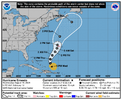
5 pm discussion:
"The new NHC track forecast has been nudged eastward after
48 hours to be close to the multi-model consensus aids, although at
this time it is too soon to know exactly how close Ernesto's center
will move to Bermuda this weekend."
INIT 14/2100Z 21.7N 68.3W 65 KT 75 MPH
12H 15/0600Z 23.5N 69.0W 75 KT 85 MPH
24H 15/1800Z 25.7N 69.0W 85 KT 100 MPH
36H 16/0600Z 27.7N 68.0W 95 KT 110 MPH
48H 16/1800Z 29.5N 66.6W 100 KT 115 MPH
60H 17/0600Z 31.3N 65.7W 95 KT 110 MPH
72H 17/1800Z 32.9N 65.4W 90 KT 105 MPH
96H 18/1800Z 37.0N 64.2W 85 KT 100 MPH
120H 19/1800Z 43.4N 58.2W 80 KT 90 MPH
Hurricane Ernesto Advisory Number 14
NWS National Hurricane Center Miami FL AL052024
1100 PM AST Wed Aug 14 2024
...ERNESTO EXPECTED TO STRENGTHEN OVER THE NEXT COUPLE OF DAYS WHILE
APPROACHING BERMUDA...
SUMMARY OF 1100 PM AST...0300 UTC...INFORMATION
-----------------------------------------------
LOCATION...23.0N 68.9W
ABOUT 175 MI...280 KM NE OF GRAND TURK ISLAND
ABOUT 690 MI...1110 KM SSW OF BERMUDA
MAXIMUM SUSTAINED WINDS...80 MPH...130 KM/H
PRESENT MOVEMENT...NNW OR 330 DEGREES AT 16 MPH...26 KM/H
MINIMUM CENTRAL PRESSURE...982 MB...29.00 INCHES
Hurricane Ernesto Discussion Number 14
NWS National Hurricane Center Miami FL AL052024
1100 PM AST Wed Aug 14 2024
The satellite structure of Ernesto has somewhat improved tonight. A
series of earlier SSMI/S 91 GHz passive microwave images showed the
formation of a mid-level eye, and there have been recent hints of an
eye trying to emerge in proxy-visible satellite images. Data from
the Air Force Hurricane Hunters showed the central pressure has
fallen to 982 mb, and the aircraft measured peak 700-mb flight-level
winds of 76 kt in the northeast quadrant. Based on these data, the
initial intensity is set at 70 kt. The wind field remains quite
broad and asymmetric, with the strongest aircraft winds well to the
northeast of the center. The next aircraft reconnaissance mission
into Ernesto is scheduled for tomorrow morning.
Ernesto is now moving north-northwestward at 330/14 kt. The
hurricane will continue on a north-northwestward to northward motion
during the next day or so while moving through a break in the
subtropical ridge over the western Atlantic. The global models agree
the upper trough that weakened the ridge will not capture Ernesto.
As a result, Ernesto will move slower to the north-northeast and
north while the hurricane approaches and moves near Bermuda Friday
night and Saturday. Later this weekend, a second trough will move
across the eastern U.S., and Ernesto should accelerate northeastward
early next week within the deep-layer southwesterly flow ahead of
this feature. The NHC track forecast is essentially an update of the
previous one, as the track guidance remains in good overall
agreement. It is still too soon to know exactly how close Ernesto's
center will move to Bermuda this weekend, but warnings will likely
be required for the island on Thursday.
While there is still evidence of some drier air nearby Ernesto, the
very warm ocean waters and weak to moderate shear should promote
some strengthening during the next couple of days. This is supported
by the bulk of the intensity guidance, and the regional hurricane
models still favor Ernesto reaching major hurricane intensity on
Friday. The latest NHC prediction remains on the high end of the
guidance envelope, closest to the HFIP corrected consensus. Some
gradual weakening is forecast thereafter as Ernesto moves into a
drier, more sheared environment. There are some indications that
positive interaction with the second upper trough could cause
Ernesto's intensity to level off or even slightly increase during
the 60-96 h time period while still over warm waters. By 120 h, the
model fields suggest Ernesto will be on the verge of losing tropical
characteristics while accelerating over cooler waters.
FORECAST POSITIONS AND MAX WINDS
INIT 15/0300Z 23.0N 68.9W 70 KT 80 MPH
12H 15/1200Z 24.7N 69.1W 80 KT 90 MPH
24H 16/0000Z 26.8N 68.6W 90 KT 105 MPH
36H 16/1200Z 28.6N 67.4W 100 KT 115 MPH
48H 17/0000Z 30.5N 66.1W 95 KT 110 MPH
60H 17/1200Z 32.2N 65.5W 90 KT 105 MPH
72H 18/0000Z 34.0N 65.2W 90 KT 105 MPH
96H 19/0000Z 38.5N 63.0W 90 KT 105 MPH
120H 20/0000Z 45.0N 55.0W 75 KT 85 MPH
$$
Forecaster Reinhart
NWS National Hurricane Center Miami FL AL052024
1100 PM AST Wed Aug 14 2024
...ERNESTO EXPECTED TO STRENGTHEN OVER THE NEXT COUPLE OF DAYS WHILE
APPROACHING BERMUDA...
SUMMARY OF 1100 PM AST...0300 UTC...INFORMATION
-----------------------------------------------
LOCATION...23.0N 68.9W
ABOUT 175 MI...280 KM NE OF GRAND TURK ISLAND
ABOUT 690 MI...1110 KM SSW OF BERMUDA
MAXIMUM SUSTAINED WINDS...80 MPH...130 KM/H
PRESENT MOVEMENT...NNW OR 330 DEGREES AT 16 MPH...26 KM/H
MINIMUM CENTRAL PRESSURE...982 MB...29.00 INCHES
Hurricane Ernesto Discussion Number 14
NWS National Hurricane Center Miami FL AL052024
1100 PM AST Wed Aug 14 2024
The satellite structure of Ernesto has somewhat improved tonight. A
series of earlier SSMI/S 91 GHz passive microwave images showed the
formation of a mid-level eye, and there have been recent hints of an
eye trying to emerge in proxy-visible satellite images. Data from
the Air Force Hurricane Hunters showed the central pressure has
fallen to 982 mb, and the aircraft measured peak 700-mb flight-level
winds of 76 kt in the northeast quadrant. Based on these data, the
initial intensity is set at 70 kt. The wind field remains quite
broad and asymmetric, with the strongest aircraft winds well to the
northeast of the center. The next aircraft reconnaissance mission
into Ernesto is scheduled for tomorrow morning.
Ernesto is now moving north-northwestward at 330/14 kt. The
hurricane will continue on a north-northwestward to northward motion
during the next day or so while moving through a break in the
subtropical ridge over the western Atlantic. The global models agree
the upper trough that weakened the ridge will not capture Ernesto.
As a result, Ernesto will move slower to the north-northeast and
north while the hurricane approaches and moves near Bermuda Friday
night and Saturday. Later this weekend, a second trough will move
across the eastern U.S., and Ernesto should accelerate northeastward
early next week within the deep-layer southwesterly flow ahead of
this feature. The NHC track forecast is essentially an update of the
previous one, as the track guidance remains in good overall
agreement. It is still too soon to know exactly how close Ernesto's
center will move to Bermuda this weekend, but warnings will likely
be required for the island on Thursday.
While there is still evidence of some drier air nearby Ernesto, the
very warm ocean waters and weak to moderate shear should promote
some strengthening during the next couple of days. This is supported
by the bulk of the intensity guidance, and the regional hurricane
models still favor Ernesto reaching major hurricane intensity on
Friday. The latest NHC prediction remains on the high end of the
guidance envelope, closest to the HFIP corrected consensus. Some
gradual weakening is forecast thereafter as Ernesto moves into a
drier, more sheared environment. There are some indications that
positive interaction with the second upper trough could cause
Ernesto's intensity to level off or even slightly increase during
the 60-96 h time period while still over warm waters. By 120 h, the
model fields suggest Ernesto will be on the verge of losing tropical
characteristics while accelerating over cooler waters.
FORECAST POSITIONS AND MAX WINDS
INIT 15/0300Z 23.0N 68.9W 70 KT 80 MPH
12H 15/1200Z 24.7N 69.1W 80 KT 90 MPH
24H 16/0000Z 26.8N 68.6W 90 KT 105 MPH
36H 16/1200Z 28.6N 67.4W 100 KT 115 MPH
48H 17/0000Z 30.5N 66.1W 95 KT 110 MPH
60H 17/1200Z 32.2N 65.5W 90 KT 105 MPH
72H 18/0000Z 34.0N 65.2W 90 KT 105 MPH
96H 19/0000Z 38.5N 63.0W 90 KT 105 MPH
120H 20/0000Z 45.0N 55.0W 75 KT 85 MPH
$$
Forecaster Reinhart
Again the ICON (0Z) has a huge hit on Bermuda with the eye barely missing it to the W. SLP of center again drops to the low 940s and rainfall is 16”, which I think would be a big record-breaker. Hopefully it won’t be this extreme there. It then turns NE and skins far SE Newfoundland.
Brent
Member
Again the ICON (0Z) has a huge hit on Bermuda with the eye barely missing it to the W. SLP of center again drops to the low 940s and rainfall is 16”, which I think would be a big record-breaker. Hopefully it won’t be this extreme there. It then turns NE and skins far SE Newfoundland.
I guess if there's any good news here Bermuda is probably the best built place in the entire basin but yeah Hopefully the models are overdone
1) 0Z Euro: 100 miles W of Bermuda to SE Newfoundland
2) 0Z UKMET: 25 miles W of Bermuda then misses Canada
HURRICANE ERNESTO ANALYSED POSITION : 22.3N 68.7W
ATCF IDENTIFIER : AL052024
LEAD CENTRAL MAXIMUM WIND
VERIFYING TIME TIME POSITION PRESSURE (MB) SPEED (KNOTS)
-------------- ---- -------- ------------- -------------
0000UTC 15.08.2024 0 22.3N 68.7W 993 48
1200UTC 15.08.2024 12 24.5N 69.4W 989 52
0000UTC 16.08.2024 24 26.4N 68.7W 984 50
1200UTC 16.08.2024 36 28.6N 67.5W 984 54
0000UTC 17.08.2024 48 30.6N 65.9W 980 55
1200UTC 17.08.2024 60 32.1N 65.2W 975 57
0000UTC 18.08.2024 72 33.0N 65.1W 977 58
1200UTC 18.08.2024 84 34.4N 65.0W 980 56
0000UTC 19.08.2024 96 36.9N 64.0W 972 64
1200UTC 19.08.2024 108 40.3N 61.7W 967 67
0000UTC 20.08.2024 120 43.8N 57.2W 971 66
1200UTC 20.08.2024 132 46.7N 49.5W 987 47
0000UTC 21.08.2024 144 49.8N 39.6W 989 43
1200UTC 21.08.2024 156 53.6N 28.1W 977 42
0000UTC 22.08.2024 168 POST-TROPICAL
Belle Lechat
Member
- Joined
- Aug 29, 2021
- Messages
- 1,529
- Reaction score
- 1,215
1) 0Z Euro: 100 miles W of Bermuda to SE Newfoundland
2) 0Z UKMET: 25 miles W of Bermuda then misses Canada
HURRICANE ERNESTO ANALYSED POSITION : 22.3N 68.7W
ATCF IDENTIFIER : AL052024
LEAD CENTRAL MAXIMUM WIND
VERIFYING TIME TIME POSITION PRESSURE (MB) SPEED (KNOTS)
-------------- ---- -------- ------------- -------------
0000UTC 15.08.2024 0 22.3N 68.7W 993 48
1200UTC 15.08.2024 12 24.5N 69.4W 989 52
0000UTC 16.08.2024 24 26.4N 68.7W 984 50
1200UTC 16.08.2024 36 28.6N 67.5W 984 54
0000UTC 17.08.2024 48 30.6N 65.9W 980 55
1200UTC 17.08.2024 60 32.1N 65.2W 975 57
0000UTC 18.08.2024 72 33.0N 65.1W 977 58
1200UTC 18.08.2024 84 34.4N 65.0W 980 56
0000UTC 19.08.2024 96 36.9N 64.0W 972 64
1200UTC 19.08.2024 108 40.3N 61.7W 967 67
0000UTC 20.08.2024 120 43.8N 57.2W 971 66
1200UTC 20.08.2024 132 46.7N 49.5W 987 47
0000UTC 21.08.2024 144 49.8N 39.6W 989 43
1200UTC 21.08.2024 156 53.6N 28.1W 977 42
0000UTC 22.08.2024 168 POST-TROPICAL
85 mph=74 kts. Ernesto is already stronger than anything forecasted in the entire lifetime of this modeling.
Belle Lechat
Member
- Joined
- Aug 29, 2021
- Messages
- 1,529
- Reaction score
- 1,215
Next plane
FLIGHT TWO - TEAL 74
AFXXX 1305A ERNESTO
Departure Time 15/0900Z 5:00 EDT
Time on Station 15/1100Z TO 15/1430Z 7:00-10:30 EDT
FLIGHT TWO - TEAL 74
AFXXX 1305A ERNESTO
Departure Time 15/0900Z 5:00 EDT
Time on Station 15/1100Z TO 15/1430Z 7:00-10:30 EDT
Belle Lechat
Member
- Joined
- Aug 29, 2021
- Messages
- 1,529
- Reaction score
- 1,215
Belle Lechat
Member
- Joined
- Aug 29, 2021
- Messages
- 1,529
- Reaction score
- 1,215
Belle Lechat
Member
- Joined
- Aug 29, 2021
- Messages
- 1,529
- Reaction score
- 1,215
Belle Lechat
Member
- Joined
- Aug 29, 2021
- Messages
- 1,529
- Reaction score
- 1,215
Belle Lechat
Member
- Joined
- Aug 29, 2021
- Messages
- 1,529
- Reaction score
- 1,215
Hurricane Ernesto Discussion Number 15
500 AM AST Thu Aug 15 2024
INIT 15/0900Z 23.9N 69.1W 75 KT 85 MPH
12H 15/1800Z 25.4N 69.1W 85 KT 100 MPH
24H 16/0600Z 27.4N 68.1W 95 KT 110 MPH
36H 16/1800Z 29.3N 66.7W 100 KT 115 MPH
48H 17/0600Z 31.1N 65.7W 95 KT 110 MPH
60H 17/1800Z 32.6N 65.4W 90 KT 105 MPH
72H 18/0600Z 34.3N 65.1W 90 KT 105 MPH
96H 19/0600Z 39.7N 62.3W 90 KT 105 MPH
120H 20/0600Z 47.0N 52.0W 65 KT 75 MPH...POST-TROPICAL
Belle Lechat
Member
- Joined
- Aug 29, 2021
- Messages
- 1,529
- Reaction score
- 1,215
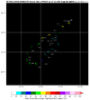
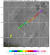
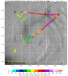
Recon, scheduled to depart in 38 min, is already over the Dominican Republic.
_
Today I learned AST (Puerto Rico) and EDT (Miami) are currently the same time.
6:23 AM
Thursday, August 15, 2024
Atlantic Standard Time (AST)
6:23 AM
Thursday, August 15, 2024
Eastern Time (ET)
_
Bermuda
7:23 AM
Thursday, August 15, 2024 (ADT)
Atlantic Daylight Time
_
Today I learned AST (Puerto Rico) and EDT (Miami) are currently the same time.
6:23 AM
Thursday, August 15, 2024
Atlantic Standard Time (AST)
6:23 AM
Thursday, August 15, 2024
Eastern Time (ET)
_
Bermuda
7:23 AM
Thursday, August 15, 2024 (ADT)
Atlantic Daylight Time
Last edited:
Belle Lechat
Member
- Joined
- Aug 29, 2021
- Messages
- 1,529
- Reaction score
- 1,215
| 14A | 08/15 2:00 AM | 23.3N | 69.1W | 85MPH | 979mb | Nnw at 16 MPH | H1 | Ernesto | 08/15 1:51 AM |
| 15 | 08/15 5:00 AM | 23.9N | 69.1W | 85MPH | 979mb | N at 13 MPH | H1 | Ernesto | 08/15 5:00 AM |
Ernesto may have reached his furthest west. Has slowed to 13 mph.
Belle Lechat
Member
- Joined
- Aug 29, 2021
- Messages
- 1,529
- Reaction score
- 1,215
Puerto Rico doesn’t observe DSTRecon, scheduled to depart in 38 min, is already over the Dominican Republic.
_
Today I learned AST (Puerto Rico) and EDT (Miami) are currently the same time.
6:23 AM
Thursday, August 15, 2024
Atlantic Standard Time (AST)
6:23 AM
Thursday, August 15, 2024
Eastern Time (ET)
_
Bermuda
7:23 AM
Thursday, August 15, 2024 (ADT)
Atlantic Daylight Time
Looks like he might be trying to clear out an eye.
Belle Lechat
Member
- Joined
- Aug 29, 2021
- Messages
- 1,529
- Reaction score
- 1,215
Belle Lechat
Member
- Joined
- Aug 29, 2021
- Messages
- 1,529
- Reaction score
- 1,215
Belle Lechat
Member
- Joined
- Aug 29, 2021
- Messages
- 1,529
- Reaction score
- 1,215
111900 2423N 06921W 6966 02956 9736 +172 +091 303011 016 018 000 00
111930 2425N 06920W 6964 02948 9736 +164 +094 258008 010 014 001 00
973.6 mb
111930 2425N 06920W 6964 02948 9736 +164 +094 258008 010 014 001 00
973.6 mb
Belle Lechat
Member
- Joined
- Aug 29, 2021
- Messages
- 1,529
- Reaction score
- 1,215
Belle Lechat
Member
- Joined
- Aug 29, 2021
- Messages
- 1,529
- Reaction score
- 1,215
| 11A | 08/14 8:00 AM | 19.8N | 67.2W | 70MPH | 991mb | Nw at 16 MPH | TS | Ernesto | 08/14 8:00 AM |
| 12 | 08/14 11:00 AM | 20.5N | 67.6W | 75MPH | 991mb | Nw at 16 MPH | H1 | Ernesto | 08/14 11:03 AM |
| 12A | 08/14 2:00 PM | 21.1N | 68.0W | 75MPH | 989mb | Nw at 16 MPH | H1 | Ernesto | 08/14 1:51 PM |
| 13 | 08/14 5:00 PM | 21.7N | 68.3W | 75MPH | 989mb | Nw at 16 MPH | H1 | Ernesto | 08/14 4:51 PM |
| 13A | 08/14 8:00 PM | 22.4N | 68.7W | 80MPH | 981mb | Nw at 16 MPH | H1 | Ernesto | 08/14 8:00 PM |
| 14 | 08/14 11:00 PM | 23.0N | 68.9W | 80MPH | 982mb | Nnw at 16 MPH | H1 | Ernesto | 08/14 10:45 PM |
| 14A | 08/15 2:00 AM | 23.3N | 69.1W | 85MPH | 979mb | Nnw at 16 MPH | H1 | Ernesto | 08/15 1:51 AM |
| 15 | 08/15 5:00 AM | 23.9N | 69.1W | 85MPH | 979mb | N at 13 MPH | H1 | Ernesto | 08/15 5:00 AM |
| 15A | 08/15 8:00 AM | 24.5N | 69.3W | 85MPH | 975mb | N at 13 MPH | H1 | Ernesto | 08/15 7:57 AM |
Last edited:
Belle Lechat
Member
- Joined
- Aug 29, 2021
- Messages
- 1,529
- Reaction score
- 1,215
2nd plane is up.
Belle Lechat
Member
- Joined
- Aug 29, 2021
- Messages
- 1,529
- Reaction score
- 1,215
Belle Lechat
Member
- Joined
- Aug 29, 2021
- Messages
- 1,529
- Reaction score
- 1,215
Belle Lechat
Member
- Joined
- Aug 29, 2021
- Messages
- 1,529
- Reaction score
- 1,215
A third plane just took off.

