Tarheelwx
Member
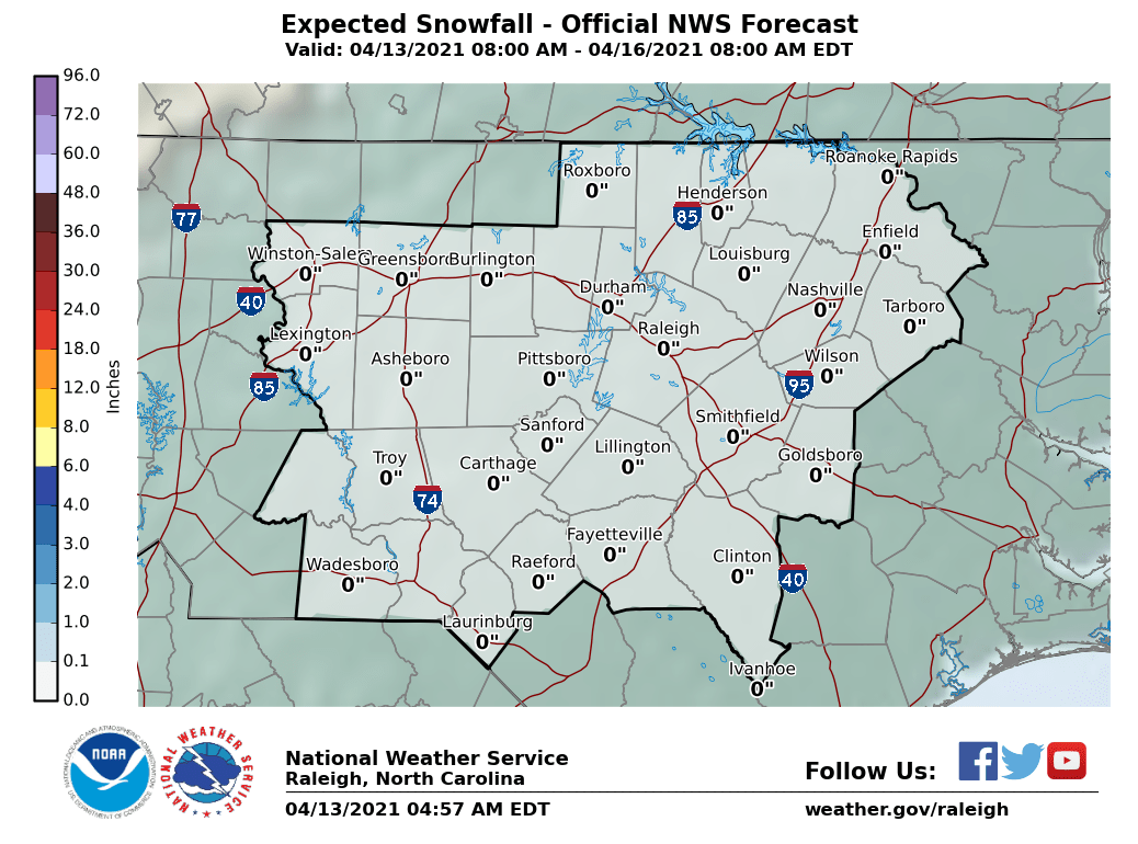
NWS has less than 1/2" for the triad. Seems this could be a bit low. I think Webber's map is more realistic. Would love to get down to 31 or so tonight.
TW
TW
I have a lot more than a couple.Brick, you got a couple inches yet?
I sure am enjoying the warm sunshine and sunny skies now!! Mega CAD in full effect!!Not sure how asking for event obs is banter but ok. Maybe take the wishcasting and model nit picking to banter also if you want to be a prick about it..Good luck with your snow
Yeah I guess showing where, when, and why some of the models are off by several degrees near initialization is just mere nit picking, maybe you can explain that to the NWS in Raleigh so they can remove the winter weather advisories they just added east of the Triad because we’re running cooler than forecast.Not sure how asking for event obs is banter but ok. Maybe take the wishcasting and model nit picking to banter also if you want to be a prick about it..Good luck with your snow
Been at the golf course since 8am. Literally have not checked radar all day. In fact I just checked it and I’m glad I did. If I only went by what I’ve read in this thread I would think RAL was about to get a foot snow. Thanks for all your helpYou know very well you weren’t just merely asking for observations when u asked brick if he had 2 inches of snow already when little-no snow had been reported SE of I 85 and most of us in the Triangle have persistently been reporting cold rain. Take your condescending negative attitude to americanwx.
I was kidding with the last post, but I’ll try again. There is sleet mixed in with the rain in Cary.Since the daycare needs reminding, keep the Brick posts out and let's also try and get along. Yes, I'm like some members here frustrated that NC is seeing snow again and we arent, but let's be adults here. Thanks.
It doesn’t matter if you get 17 traces at the daycare, your total is still a trace!I was kidding with the last post, but I’ll try again. There is sleet mixed in with the rain in Cary.

Sad!It doesn’t matter if you get 17 traces at the daycare, your total is still a trace!
Does the fact that we’re seeing that now portend anything or tell you anything about later on? I was under the impression (maybe mistakenly so) that any frozen precip would occur later tonight.Sleet rain mix here near Cary and NC States campus. We hit our Trace of snow and sleet
I'm not sure we can pull this one off this far south. We are going to need some heavy precip to erode the warm layer. I wish I was still in knightdale for this one. Bricks backyard looks good imoDoes the fact that we’re seeing that now portend anything or tell you anything about later on? I was under the impression (maybe mistakenly so) that any frozen precip would occur later tonight.

It tells me that the column has to be very cold aloft for us to have any wintry precipitation atm and reaffirms the fact that as the rates increase with the banding later tonight the chances for snow/sleet increase substantially. Anyone in the pink area on my map i posted earlier imo has a “legitimate” shot of seeing at least one or a few quick bursts of heavy wet snow and/or sleet that could accumulate up to an inch or so mainly on grassy and elevated surfaces however small that chance may be. Areas as far south as Lillington, Sanford, Smithfield, Wilson, and Greenville could get involved. I was banking on favorable adjustments to happen because I kept watching the 3km NAM and HRRR verify near or warmer than forecast due in large part to the fact they didn’t handle the first bout of precipitation correctly at all. Isentropic upglide, like we often see time and time again in overrunning events in the heart of winter and what we’re seeing now is usually poorly forecast by the models (likely because they don’t have sufficient vertical resolution) and the precipitation on the downwind side (typically to the north) is underdone. Also seeing what happened a few weeks ago to the HRRR and other CAMs when they mishandled the southeastern extent of the snowfall that fell all the way to the coast instead of staying near and NW Raleigh gave me enough confidence to mention the potential even in Harnett, Lee, & Johnston counties.Does the fact that we’re seeing that now portend anything or tell you anything about later on? I was under the impression (maybe mistakenly so) that any frozen precip would occur later tonight.