Got the GFSFV3 onboard! ?


 ️
️


 ️
️
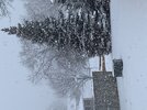
I almost chased this oneJust started!
Man that’s a serious radar return to only be getting virga
Just started!

10 AM (cst) update


Can you please take a picture of something other than your chair ?10 AM (cst) updateView attachment 133303
YesCan you please take a picture of something other than your chair ?


Damn wish I was there!!Final death band bringing the goods!View attachment 133317View attachment 133318View attachment 133319
 www.weatherzone.com.au
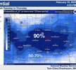
Minneapolis St Paul?Looks like the Twin Cities are really going to get hammered next week.
Yes.Minneapolis St Paul?
I’m at 35” on the dot for the winter! I’m good with just rain the rest of the winter!Looks like the Twin Cities are really going to get hammered next week.
Unfortunately for you, you may be on the outside looking in next week.I’m at 35” on the dot for the winter! I’m good with just rain the rest of the winter!

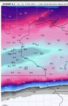
Damn you were right!! Paisley Park time!!!Unfortunately for you, you may be on the outside looking in next week.
It’ll shift South as we get closer, has all winter. There won’t be as much SE ridge as modeledUnfortunately for you, you may be on the outside looking in next week.
With a touch of mall of America!Damn you were right!! Paisley Park time!!!
Can’t help but feel like this is a shot for my area!! LolIt’ll shift South as we get closer, has all winter. There won’t be as much SE ridge as modeled
Okay, didn’t know if you were talking about Nashville and MurfreesboroYes.


This is insane.