Brent
Member
Just found a wind tunnel on a frozen lake near Rocky Mountain National Park 
 that was insane it started to snow as I approached too

The Denver area has the most variable weather in the country and its not even close. I roll my eyes when anyone in Alabama says it.No words. Denver is in the 60s and I was an hour and a half away
Colorado is definitely not like many other states
You’re right. If you look at their average temperatures, it’s really not as low as you would expect with the amount of snow they average. I think the lowest average highs are in the lower 40s. It’s literally because they’re so many days that will be near 60 one day and then near 20 the next. Also it’s interesting how shallow those Arctic airmasses can get there. One time about 15 years ago I was on a business trip there and the temperature in town was in the single digits in the early afternoon, while at the ski resorts just to the west of town had temperatures in the upper 20sThe Denver area has the most variable weather in the country and its not even close. I roll my eyes when anyone in Alabama says it.
You’re right. If you look at their average temperatures, it’s really not as low as you would expect with the amount of snow they average. I think the lowest average highs are in the lower 40s. It’s literally because they’re so many days that will be near 60 one day and then near 20 the next. Also it’s interesting how shallow those Arctic airmasses can get there. One time about 15 years ago I was on a business trip there and the temperature in town was in the single digits in the early afternoon, while at the ski resorts just to the west of town had temperatures in the upper 20s
Yeah man. When I ski’d Breckinridge in the late 2000’s a couple times I remember driving from Denver and it being sunny skies but when I hit that first tunnel in the mountains and got to the other side of the pass it was blowing snow and freezing cold. That place is wild.No words. Denver is in the 60s and I was an hour and a half away
Colorado is definitely not like many other states
Yeah man. When I ski’d Breckinridge in the late 2000’s a couple times I remember driving from Denver and it being sunny skies but when I hit that first tunnel in the mountains and got to the other side of the pass it was blowing snow and freezing cold. That place is wild.
I mean there was so much snow at Loveland you could barely walk on it. I didn't even see that yesterday in the national park 2-3k feet lower
More cold and more snow in Niñas here! This was still the worsts winter out of 4 for me! Even with the 10 day stretch of amazing snow, my first 3 winters here were great , with 50-60”+ all 3 winters! Think I’m holding at about 30” now and set all time winter record highs in a lot of Iowa today! (D-F)Looking ahead what are the implications of a strong La Niña for next winter? I like to think the Midwest fairs better but with these global ocean temps who knows.
Sent from my iPhone using Tapatalk
More cold and more snow in Niñas here! This was still the worsts winter out of 4 for me! Even with the 10 day stretch of amazing snow, my first 3 winters here were great , with 50-60”+ all 3 winters! Think I’m holding at about 30” now and set all time winter record highs in a lot of Iowa today! (D-F)
Tornado sirens here in Naperville in February - wild. Last year was a strong nina and relatively snowless in Chicago. I hope that was a fluke.
Sent from my iPhone using Tapatalk
there have been several back to back winters so thats not unheard ofI've looked here and I can't find any examples of going 3 years with as little snow as we've had the last two here so I mean... I would assume things cant get any worsethere have been several back to back winters so thats not unheard of
I mean apparently today Tulsa set the longest stretch of 70+ degree highs on record in the winter so the bar is pretty low at this point
I swear I moved north and brought the climate with me.
Sent from my iPhone using Tapatalk
Just from reading some of the Lakes Ohio Valley thread at the other place, Chicago is usually the battleground for frozen and rain on most storms.Tornado sirens here in Naperville in February - wild. Last year was a strong nina and relatively snowless in Chicago. I hope that was a fluke.
Sent from my iPhone using Tapatalk
@Brent anyone .
How far away from the Pantex plant is this fire? Is it heading away or towards?
View attachment 146990


 first time on record apparently


.png")
 )
)


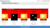
Saw that, THAT'S impressive. Here's Death Valley this week. Highest all time verified temp is 130, the 1913 134 is being questioned. This is rarified air.Las Vegas didn’t just hit 118. They hit 120!
LAS VEGAS FAIR 118 17 3 NW7G20 29.75F 6HR MIN TEMP: 107; 6HR MAX TEMP: 120
That beats their old all-time high by 3! Records go back to 1937.

Saw that, THAT'S impressive. Here's Death Valley this week. Highest all time verified temp is 130, the 1913 134 is being questioned. This is rarified air.
Saw that, THAT'S impressive. Here's Death Valley this week. Highest all time verified temp is 130, the 1913 134 is being questioned. This is rarified air.
I'll be there in a few weeks, I'll let you know lol96 for a low? Damn. Death for sure if you get stuck there.
Sent from my iPhone using Tapatalk
When are you retiring ?I'll be there in a few weeks, I'll let you know lol
 there have been several back to back winters so thats not unheard of