The line of storms seemed pretty good today, too. I didn't get anything yesterday, and had a severe warned storm today with lots of thunder, lightning and rain. I saw pics from a friend in Greensboro of trees down there. This line also produced some tornado warnings, and is still going at the coast.Yep fizzled as it got here, not surprised those storms last night stole the show
-
Hello, please take a minute to check out our awesome content, contributed by the wonderful members of our community. We hope you'll add your own thoughts and opinions by making a free account!
You are using an out of date browser. It may not display this or other websites correctly.
You should upgrade or use an alternative browser.
You should upgrade or use an alternative browser.
Pattern Oh my its July
- Thread starter SD
- Start date
4:37 PM Tornado Warning continues for South Central Onslow County; weather spotters reported a rotating walk cloud.
At 431 PM EDT, trained weather spotters reported a rotating wall
cloud over Sea View Pier, or near North Topsail Beach, moving
northeast at 15 mph.
HAZARD...Tornado.
SOURCE...Weather spotters confirmed wall cloud.
IMPACT...Flying debris will be dangerous to those caught without
shelter. Mobile homes will be damaged or destroyed. Damage
to roofs, windows, and vehicles will occur. Tree damage is
likely.
Locations impacted include...
North Topsail Beach, Folkstone, Onslow Beach, Sneads Ferry, Sea View Pier and Holly Ridge.
Yep, but here where I live we had big time rains last night, those storms fizzled here. I didn't say it fizzled in other areas, just hereThe line of storms seemed pretty good today, too. I didn't get anything yesterday, and had a severe warned storm today with lots of thunder, lightning and rain. I saw pics from a friend in Greensboro of trees down there. This line also produced some tornado warnings, and is still going at the coast.
znel52
Member
As usual everything weakened out right before it got to me. It gets frustrating watching lines fall apart almost every time they approach. They usually stay strong to the NE and SE and split right around this area. 

Sent from my SM-S918U using Tapatalk


Sent from my SM-S918U using Tapatalk
Shaggy
Member
Sun is out now. At least the storm cooled things down.
.3 today 2.64 for the month so far
Had 2 days of massive gully washers. Time for the 4 weeks of Dog Days to start. Ready for it, so we can get it in the rear view mirror.
Bannerdude
Member
The line yesterday helped but I've been unlucky over the past several days...only 1.04 for the month so far
Iceagewhereartthou
Member
Yoda says, "If into the GFS you go, only pain will you find."
12 actually looks pretty good. Rainfall amounts are probably underdone, if the 500 mb pattern comes true. No real heatwaves either.Yoda says, "If into the GFS you go, only pain will you find."
12 actually looks pretty good. Rainfall amounts are probably underdone, if the 500 mb pattern comes true. No real heatwaves either.
This right here. While summer has sprung, as long as a big heat dome doesn’t set up at least we can hope for the slow normal step down in temps instead of 90’s into October.
I hope the pattern stays this way. The heat is much easier to get through if you have confidence it will end when it should.
61 this morning which is pretty rare this time of year. Picked up another inch night before last and dodged the flooding stuff.
Drizzle Snizzle
Member
Wow. Atlanta only got down to 71 I think.61 this morning which is pretty rare this time of year. Picked up another inch night before last and dodged the flooding stuff.
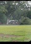
Spent the weekend up near Boone working on the house. I left yesterday afternoon, but should have stay one more night:

Here's a little fantasy (..or horror). 6z GFS day 12 ~noon:

Of course, not way this happens. This would be all time highs for many of us.
Of course, not way this happens. This would be all time highs for many of us.
About to max out the color scale.Here's a little fantasy (..or horror). 6z GFS day 12 ~noon:
View attachment 135717
Of course, not way this happens. This would be all time highs for many of us.
severestorm
Member
Nino doing work already!
BHS1975
Member
Nino doing work already!
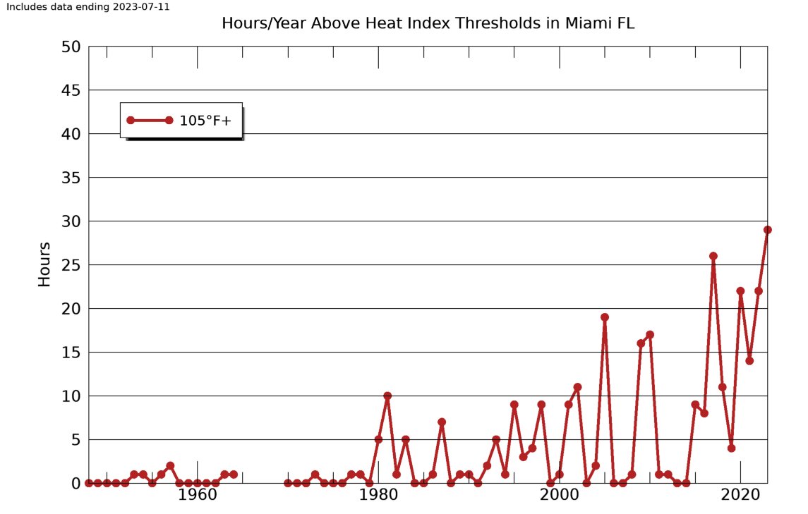
Why the little effect before 1980? Threshold too high?
Sent from my iPhone using Tapatalk
BHS1975
Member
These lows are brutal.

Sent from my iPhone using Tapatalk

Sent from my iPhone using Tapatalk
These lows are brutal.
Sent from my iPhone using Tapatalk
Typical Summer morning in Dallas these days...

.png")


Brent
Member
Hope all the summer people are happy. Oh well it was inevitable eventually Tulsa had 27 days over 100 last year
Your forecast just a few days ago must have been wrong that you posted. ?Hope all the summer people are happy. Oh well it was inevitable eventually Tulsa had 27 days over 100 last yearView attachment 135725
BHS1975
Member
Hope all the summer people are happy. Oh well it was inevitable eventually Tulsa had 27 days over 100 last yearView attachment 135725
HRRR showing dews around 80 for Tulsa tomorrow.
Sent from my iPhone using Tapatalk
Hope all the summer people are happy. Oh well it was inevitable eventually Tulsa had 27 days over 100 last yearView attachment 135725
An Excessive Heat Warning is forthcoming for Dallas as well.
An Excessive Heat Warning is forthcoming for Dallas as well.
And there it is...
URGENT - WEATHER MESSAGE
National Weather Service Fort Worth TX
151 AM CDT Wed Jul 12 2023
TXZ091>095-100>107-115>123-129>135-141>148-156>162-174-175-121815-
/O.UPG.KFWD.HT.Y.0005.000000T0000Z-230713T0200Z/
/O.NEW.KFWD.EH.W.0004.230712T0651Z-230714T0200Z/
Montague-Cooke-Grayson-Fannin-Lamar-Young-Jack-Wise-Denton-Collin-
Hunt-Delta-Hopkins-Stephens-Palo Pinto-Parker-Tarrant-Dallas-
Rockwall-Kaufman-Van Zandt-Rains-Eastland-Erath-Hood-Somervell-
Johnson-Ellis-Henderson-Comanche-Mills-Hamilton-Bosque-Hill-
Navarro-Freestone-Anderson-Lampasas-Coryell-Bell-McLennan-Falls-
Limestone-Leon-Milam-Robertson-
Including the cities of Bowie, Nocona, Gainesville, Sherman,
Denison, Bonham, Paris, Graham, Olney, Jacksboro, Decatur,
Bridgeport, Carrollton, Denton, Lewisville, Flower Mound, Plano,
McKinney, Allen, Frisco, Greenville, Commerce, Cooper,
Sulphur Springs, Breckenridge, Mineral Wells, Weatherford, Briar,
Fort Worth, Arlington, Dallas, Rockwall, Heath, Terrell, Kaufman,
Forney, Canton, Grand Saline, Wills Point, Van, Edgewood, Emory,
East Tawakoni, Point, Cisco, Eastland, Ranger, Gorman,
Stephenville, Dublin, Granbury, Oak Trail Shores, Glen Rose,
Cleburne, Burleson, Waxahachie, Ennis, Midlothian, Athens,
Gun Barrel City, Comanche, De Leon, Goldthwaite, Hamilton, Hico,
Clifton, Meridian, Valley Mills, Hillsboro, Corsicana, Teague,
Fairfield, Wortham, Palestine, Lampasas, Copperas Cove,
Gatesville, Killeen, Temple, Fort Cavazos, Waco, Marlin, Mexia,
Groesbeck, Buffalo, Centerville, Jewett, Normangee, Oakwood,
Cameron, Rockdale, Hearne, Franklin, and Calvert
151 AM CDT Wed Jul 12 2023
...EXCESSIVE HEAT WARNING IN EFFECT UNTIL 9 PM CDT THURSDAY...
* WHAT...Dangerously hot conditions with heat index values up to
114.
* WHERE...All of North and Central Texas.
* WHEN...Until 9 PM CDT Thursday.
* IMPACTS...Extreme heat and humidity will significantly increase
the potential for heat related illnesses, particularly for those
working or participating in outdoor activities.
PRECAUTIONARY/PREPAREDNESS ACTIONS...
Drink plenty of fluids, stay in an air-conditioned room, stay out
of the sun, and check up on relatives and neighbors. Young
children and pets should never be left unattended in vehicles
under any circumstances.
Take extra precautions if you work or spend time outside. When
possible, reschedule strenuous activities to early morning or
evening. Know the signs and symptoms of heat exhaustion and heat
stroke. Wear lightweight and loose fitting clothing when
possible. To reduce risk during outdoor work, the Occupational
Safety and Health Administration recommends scheduling frequent
rest breaks in shaded or air conditioned environments. Anyone
overcome by heat should be moved to a cool and shaded location.
Heat stroke is an emergency! Call 9 1 1.
&&
$$
Barnes
Got some hot tub water in the Florida Keys.
 www.ndbc.noaa.gov
NDBC - 5-day plot - Water Temperature at JKYF1
National Data Buoy Center - 5-day plot - Water Temperature at station JKYF1 (25.053N 80.904W) - Johnson Key, FL.
50 days til Meteorological Fall
Brent
Member
That humidity is something else
Brent
Member
Your forecast just a few days ago must have been wrong that you posted. ?
True although there is still allegedly a front this weekend. Today and tomorrow is the peak for sure until then
BHS1975
Member
That humidity is something elseView attachment 135727
I mean you've basically got steam coming off the gulf.
Sent from my iPhone using Tapatalk
BHS1975
Member
NDBC - Observations - Radial Search
Provides nearby marine weather observations for a specified location, range and time frame.
Sent from my iPhone using Tapatalk
BHS1975
Member
Oooof

Sent from my iPhone using Tapatalk

Sent from my iPhone using Tapatalk
lol at the radar/satellite this morning.
What a weird Summer...
What a weird Summer...
It's crazy how the eps goes wildly hot in the extended over the past 2 summers
Iceagewhereartthou
Member
https://external-content.duckduckgo.com/iu/?u=http%3A%2F%2F3.--.blogspot.com%2F-J89j9fBGAQ4%2FVilFeXewQuI%2FAAAAAAAAdVY%2FRhq_S8wUrig%2Fs1600%2Fautumn-hd-wallpapers-hd-wallpapers.jpg&f=1&nofb=1&ipt=439777fdb92eeba73a065efadca85652a27d5dadd796569c5ae69a98053bf997&ipo=images50 days til Meteorological Fall

Iceagewhereartthou
Member


Drizzle Snizzle
Member
108 there feels better than 90 here.